Category:Elloughton-cum-Brough
Jump to navigation
Jump to search
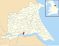
English: Elloughton-cum-Brough, a civil parish in the East Riding of Yorkshire, England. It comprises the town of Brough and the village of Elloughton.
civil parish in the East Riding of Yorkshire, England | |||||
| Upload media | |||||
| Instance of | |||||
|---|---|---|---|---|---|
| Named after | |||||
| Location | East Riding of Yorkshire, Yorkshire and the Humber, England | ||||
| Population |
| ||||
| official website | |||||
 | |||||
Subcategories
This category has the following 2 subcategories, out of 2 total.
B
E
Media in category "Elloughton-cum-Brough"
The following 178 files are in this category, out of 178 total.
-
 "The Ferry Inn", Brough - geograph.org.uk - 3155822.jpg 4,402 × 2,935; 3.25 MB
-

-
 A long straight wall - geograph.org.uk - 3872170.jpg 4,320 × 3,240; 1.65 MB
-
 A monochrome scene - geograph.org.uk - 3872128.jpg 3,176 × 4,272; 1.67 MB
-
 A63 at Dale Road overbridge, Elloughton - geograph.org.uk - 5925025.jpg 1,024 × 779; 130 KB
-
 A63 westbound Elloughton - geograph.org.uk - 4776506.jpg 4,464 × 3,256; 5.19 MB
-
 Across the Humber at Brough - geograph.org.uk - 2219152.jpg 640 × 447; 211 KB
-
 Assorted Vent Stacks - geograph.org.uk - 6337324.jpg 3,580 × 2,193; 1.23 MB
-
 Barclays Bank, Brough - geograph.org.uk - 4380913.jpg 4,000 × 2,248; 1.55 MB
-
 Beech Road, Elloughton - geograph.org.uk - 5663532.jpg 2,848 × 2,136; 1.46 MB
-
 Blenheim Avenue, Brough - geograph.org.uk - 6693383.jpg 1,024 × 657; 1.12 MB
-
 Bridge over railway Saltgrounds Road Brough - geograph.org.uk - 4776434.jpg 4,608 × 3,456; 5.25 MB
-
 Bridleway above Elloughton - geograph.org.uk - 4223437.jpg 768 × 1,024; 325 KB
-
 Bridleway across Brough Aerodrome - geograph.org.uk - 4136702.jpg 1,024 × 768; 97 KB
-
 Bridleway across the Runway - geograph.org.uk - 6337328.jpg 3,933 × 3,036; 4.18 MB
-
 Bridleway across the Runway - geograph.org.uk - 6337330.jpg 2,620 × 3,448; 2.67 MB
-
 Bridleway across the taxiway - geograph.org.uk - 4136713.jpg 1,024 × 768; 142 KB
-
 Bridleway at Peggy Farrow Lane - geograph.org.uk - 5699875.jpg 1,600 × 1,064; 707 KB
-
 Bridleway to Common Lane - geograph.org.uk - 4136721.jpg 1,024 × 768; 155 KB
-
 Brough Coffee Kiosk on Brough Train Station - geograph.org.uk - 4466247.jpg 2,448 × 1,624; 912 KB
-
 Brough Golf Course viewed from Ellougton Road - geograph.org.uk - 4880294.jpg 4,608 × 3,456; 3.68 MB
-
 Brough Haven approaching high tide - geograph.org.uk - 4379304.jpg 4,000 × 2,248; 1.79 MB
-
 Brough Haven at low tide - geograph.org.uk - 4379299.jpg 3,966 × 2,188; 5.04 MB
-
 Brough Haven entrance - geograph.org.uk - 2224034.jpg 512 × 640; 215 KB
-
 Brough Police Station Welton Road - geograph.org.uk - 4785744.jpg 4,604 × 3,450; 4.55 MB
-
 Brough railway station - geograph.org.uk - 4382816.jpg 800 × 533; 143 KB
-
 Brough Roads - geograph.org.uk - 4136688.jpg 1,024 × 768; 98 KB
-
 Brough Roads - geograph.org.uk - 4379283.jpg 3,936 × 2,128; 4.9 MB
-
 Brough Roads, low tide - geograph.org.uk - 4136685.jpg 1,024 × 768; 134 KB
-
 Brough Station - geograph.org.uk - 4550011.jpg 640 × 426; 57 KB
-
 Brough, Railway, looking west - geograph.org.uk - 1881157.jpg 3,456 × 2,304; 6.97 MB
-
 Brough, The 'Station Supper Bar' - geograph.org.uk - 1881147.jpg 3,456 × 2,304; 5.3 MB
-
 Brunch Club on Skillings Lane, Brough - geograph.org.uk - 6685706.jpg 1,600 × 1,065; 557 KB
-
 Building site at Elloughton - geograph.org.uk - 4380898.jpg 4,000 × 2,248; 5.18 MB
-
 Cappers West Float, on a falling tide - geograph.org.uk - 3624711.jpg 1,024 × 615; 71 KB
-
 Cappers West Float, River Humber - geograph.org.uk - 3597017.jpg 1,024 × 768; 175 KB
-
 Car park, Brough Post Office - geograph.org.uk - 5663661.jpg 2,848 × 2,136; 1.43 MB
-
 Castle House - geograph.org.uk - 4217113.jpg 1,024 × 768; 247 KB
-
 Cave Road, Brough - geograph.org.uk - 3829295.jpg 2,851 × 1,772; 736 KB
-
 Chantreys Drive off Elloughton Road, Brough - geograph.org.uk - 6685712.jpg 1,600 × 1,065; 520 KB
-
 Chantreys Drive, Elloughton - geograph.org.uk - 5972775.jpg 1,024 × 742; 245 KB
-
 Church Lane, Elloughton - geograph.org.uk - 4342174.jpg 640 × 464; 195 KB
-
 Church Street, Elloughton - geograph.org.uk - 6686223.jpg 1,600 × 1,065; 459 KB
-
 Close up, Elizabeth II postbox on Alder Close, Brough - geograph.org.uk - 5663683.jpg 1,232 × 1,922; 549 KB
-

-

-

-

-
 Crossroads at foot of Elloughton Dale - geograph.org.uk - 5952237.jpg 1,024 × 768; 178 KB
-
 Dale Road, Elloughton - geograph.org.uk - 2208541.jpg 800 × 600; 240 KB
-
 Debris on the shoreline - geograph.org.uk - 3872153.jpg 3,240 × 4,320; 2.83 MB
-
 Derelict land on the edge of Brough - geograph.org.uk - 4550020.jpg 640 × 426; 54 KB
-

-
 Drainage work on Elloughton Ings - geograph.org.uk - 4379335.jpg 4,000 × 2,248; 4.6 MB
-
 Eastbound layby on the A63 - geograph.org.uk - 3521785.jpg 1,024 × 768; 94 KB
-
 Elizabeth II postbox on Alder Close, Brough - geograph.org.uk - 5663681.jpg 2,848 × 2,136; 1.48 MB
-
 Elizabeth II postbox on Elloughton Road, Brough - geograph.org.uk - 5663741.jpg 2,136 × 2,848; 1.22 MB
-
 Elizabeth II postbox on Humber Crescent, Brough - geograph.org.uk - 5664560.jpg 2,848 × 2,136; 1.23 MB
-
 Elizabeth II postbox on Main Street, Elloughton - geograph.org.uk - 5663528.jpg 2,136 × 2,848; 1.22 MB
-
 Elizabeth II postbox on Station Road, Brough - geograph.org.uk - 5664571.jpg 2,848 × 2,136; 1.41 MB
-
 Elizabeth II postbox on Stockbridge Road, Brough - geograph.org.uk - 5663757.jpg 2,848 × 2,136; 1.27 MB
-
 Elizabeth II postbox, Brough Post Office - geograph.org.uk - 5663658.jpg 1,595 × 2,848; 934 KB
-
 Elloughton Dale (road), Elloughton - geograph.org.uk - 5700017.jpg 1,600 × 1,064; 918 KB
-
 Elloughton Road, Brough - geograph.org.uk - 5663745.jpg 2,848 × 2,136; 1.42 MB
-
 Elloughton Road, Brough - geograph.org.uk - 5663746.jpg 2,848 × 2,136; 1.24 MB
-
 Elloughton Road, Brough - geograph.org.uk - 6685708.jpg 1,600 × 1,065; 481 KB
-
 Elloughton United Reformed Cemetery - geograph.org.uk - 4223423.jpg 1,024 × 768; 295 KB
-
 Elloughton United Reformed Church - geograph.org.uk - 6686219.jpg 1,600 × 1,065; 479 KB
-
 Elloughton, the old Half Moon pub - geograph.org.uk - 4505325.jpg 640 × 427; 61 KB
-
 Elloughton-cum-Brough UK parish locator map.svg 1,425 × 1,107; 1.68 MB
-

-
 Entrance to Brough Haven at low water - geograph.org.uk - 4776413.jpg 4,608 × 3,456; 4.31 MB
-
 Field drain - geograph.org.uk - 4549998.jpg 640 × 426; 42 KB
-
 Float 33, Brough Roads, River Humber - geograph.org.uk - 3589556.jpg 1,024 × 768; 73 KB
-
 Float 33A, Brough Roads, River Humber - geograph.org.uk - 3589548.jpg 1,024 × 768; 70 KB
-
 Flood Barrier at Brough Haven - geograph.org.uk - 4926066.jpg 1,200 × 799; 320 KB
-
 Former Elloughton Post Office - geograph.org.uk - 5664032.jpg 640 × 480; 67 KB
-
 Former Odd Fellows Hall - geograph.org.uk - 5633997.jpg 1,064 × 1,600; 588 KB
-

-
 George V postbox on Skillings Lane, Brough - geograph.org.uk - 5664395.jpg 1,435 × 2,605; 810 KB
-

-
 Grange Park, Brough - geograph.org.uk - 5972692.jpg 1,024 × 768; 201 KB
-
 Half Moon Public House Elloughton - geograph.org.uk - 4776489.jpg 4,608 × 3,456; 5.44 MB
-
 Heading back towards the Humber - geograph.org.uk - 2106232.jpg 800 × 600; 305 KB
-
 House on Alder Close, Brough - geograph.org.uk - 5663687.jpg 640 × 480; 61 KB
-
 Houses on Main Street, Elloughton - geograph.org.uk - 6685714.jpg 1,600 × 1,065; 369 KB
-
 Houses on Main Street, Elloughton - geograph.org.uk - 6685715.jpg 1,600 × 1,065; 527 KB
-
 Houses on Station Road, Brough - geograph.org.uk - 5664574.jpg 2,463 × 1,788; 970 KB
-
 Houses, Brough - geograph.org.uk - 3829268.jpg 1,920 × 1,076; 268 KB
-
 Houses, Sidings Court - geograph.org.uk - 4550008.jpg 640 × 426; 61 KB
-
 Humber Crescent, Brough - geograph.org.uk - 2174885.jpg 800 × 600; 285 KB
-
 Humber Crescent, Brough - geograph.org.uk - 3829278.jpg 1,920 × 1,131; 310 KB
-
 Humber Crescent, Brough - geograph.org.uk - 5664565.jpg 640 × 480; 71 KB
-
 Humber Float 33, on a falling tide - geograph.org.uk - 3624698.jpg 1,024 × 768; 107 KB
-
 Humber footpath near Brough - geograph.org.uk - 2590911.jpg 640 × 408; 203 KB
-
 Industrial Unit, Ings Lane - geograph.org.uk - 4550004.jpg 640 × 426; 50 KB
-
 Industry, Ings Lane - geograph.org.uk - 4550006.jpg 640 × 426; 49 KB
-
 Jogging along, Dale Road, Elloughton - geograph.org.uk - 4505324.jpg 640 × 427; 80 KB
-
 Kingston White Public Telephone Box in the Snow - geograph.org.uk - 4367489.jpg 1,600 × 1,200; 758 KB
-
 Lapwings over Brough airfield - geograph.org.uk - 4136696.jpg 1,024 × 768; 71 KB
-
 Main Street Elloughton - geograph.org.uk - 4776470.jpg 4,504 × 3,314; 4.98 MB
-
 Main Street, Elloughton - geograph.org.uk - 2121832.jpg 800 × 600; 209 KB
-
 Main Street, Elloughton - geograph.org.uk - 4505332.jpg 640 × 427; 61 KB
-
 Middle Whitton Float, on a falling tide - geograph.org.uk - 3624676.jpg 1,024 × 614; 74 KB
-
 Middle Whitton Float, River Humber - geograph.org.uk - 3597026.jpg 1,024 × 768; 117 KB
-
 Mill Lane from Main Street - geograph.org.uk - 4776464.jpg 4,594 × 3,438; 6.95 MB
-
 Mill Lane West - geograph.org.uk - 4217089.jpg 1,024 × 768; 232 KB
-
 Moorings at Brough Haven - geograph.org.uk - 4382813.jpg 800 × 533; 121 KB
-
 Morning sun on Dam Green Lane Elloughton - geograph.org.uk - 4776512.jpg 4,498 × 3,304; 6.19 MB
-
 Muddy start - geograph.org.uk - 4223427.jpg 1,024 × 768; 317 KB
-
 New building off King Edwards Terrace, Brough - geograph.org.uk - 4926059.jpg 1,200 × 799; 297 KB
-
 New Housing Estate north of Brough Airfield - geograph.org.uk - 6026801.jpg 3,833 × 2,173; 1.91 MB
-

-
 Over the reed beds yachts in Brough Haven - geograph.org.uk - 4776426.jpg 4,608 × 3,456; 3.71 MB
-
 Peggy Farrow Lane - geograph.org.uk - 4223432.jpg 1,024 × 768; 336 KB
-
 Peggy Farrow Lane towards Elloughton Dale (road) - geograph.org.uk - 5699885.jpg 1,600 × 1,064; 869 KB
-
 Police Station at Brough, East Yorkshire - geograph.org.uk - 2017276.jpg 800 × 600; 233 KB
-
 Pre-cyclists motorbike on the Tour de Yorkshire - geograph.org.uk - 6140307.jpg 2,688 × 3,456; 1.75 MB
-
 Pre-cyclists police cars on the Tour de Yorkshire - geograph.org.uk - 6140305.jpg 4,608 × 3,456; 2.88 MB
-
 Quiet corner of Brough Golf Club on Mill Hill - geograph.org.uk - 4380907.jpg 4,000 × 2,248; 4.54 MB
-
 Railway line toward Brough Station - geograph.org.uk - 4785756.jpg 4,596 × 3,440; 5.12 MB
-
 Reed Bed Overlooking Brough Roads - geograph.org.uk - 4880896.jpg 4,492 × 3,303; 3.41 MB
-
 Repainting the handrails at Brough Train Station - geograph.org.uk - 4926053.jpg 1,200 × 799; 355 KB
-
 River Defence Works at Brough Airfield - geograph.org.uk - 2106207.jpg 800 × 600; 174 KB
-
 Road sign on Dale Road, Elloughton - geograph.org.uk - 6686286.jpg 1,600 × 1,065; 789 KB
-
 Roman Sculpture in Brough - geograph.org.uk - 4880292.jpg 4,222 × 3,133; 3.12 MB
-
 Rough grassland - geograph.org.uk - 4549997.jpg 640 × 426; 38 KB
-
 Rough ground by Brough Aerodrome - geograph.org.uk - 4550673.jpg 640 × 255; 29 KB
-
 Saltgrounds Road, Brough - geograph.org.uk - 2106222.jpg 800 × 600; 270 KB
-
 Sand Lane - geograph.org.uk - 4217107.jpg 1,024 × 768; 284 KB
-
 Sand Lane crossing the golf course - geograph.org.uk - 4217111.jpg 1,024 × 768; 188 KB
-
 Shops at Brough crossroads - geograph.org.uk - 2017279.jpg 800 × 600; 216 KB
-
 Shops at Elloughton - geograph.org.uk - 4380902.jpg 4,000 × 2,248; 4.71 MB
-
 Shops on Main Street - geograph.org.uk - 4382823.jpg 800 × 577; 133 KB
-
 Shops on Skillings Lane, Brough - geograph.org.uk - 6685703.jpg 1,600 × 1,065; 706 KB
-
 Sign post at bottom of High Hill, Elloughton - geograph.org.uk - 4380187.jpg 1,280 × 960; 1.55 MB
-
 Signpost at Elloughton Clough - geograph.org.uk - 4136699.jpg 1,024 × 768; 134 KB
-
 Skillings Lane - geograph.org.uk - 4550007.jpg 640 × 426; 64 KB
-
 Skillings Lane, Brough - geograph.org.uk - 5664401.jpg 2,848 × 2,136; 1.44 MB
-
 Skillings Lane, Brough - geograph.org.uk - 5664403.jpg 2,848 × 2,136; 1.35 MB
-
 St Mary's Church, Elloughton - geograph.org.uk - 6485510.jpg 1,024 × 847; 1.45 MB
-
 Staggered Crossroads at Elloughton - geograph.org.uk - 4880300.jpg 4,116 × 3,067; 3.28 MB
-
 Station Road towards Brough Station - geograph.org.uk - 6680160.jpg 1,600 × 1,065; 451 KB
-
 Station Road towards Brough Station - geograph.org.uk - 6680186.jpg 1,600 × 1,065; 428 KB
-
 Station Road, Brough - geograph.org.uk - 5664572.jpg 2,848 × 2,136; 1.44 MB
-
 Stockbridge Road Elloughton - geograph.org.uk - 4481793.jpg 1,024 × 699; 152 KB
-
 Stockbridge Road, Brough - geograph.org.uk - 5663761.jpg 2,848 × 2,136; 1.23 MB
-
 Stockbridge Road, Brough - geograph.org.uk - 5663765.jpg 2,848 × 2,136; 1.44 MB
-
 Stream through the middle of Brough Golf Course - geograph.org.uk - 4776451.jpg 4,608 × 3,456; 4.33 MB
-
 Sunlit Cemetery - geograph.org.uk - 1943142.jpg 2,816 × 2,112; 2.93 MB
-
 Survey vessel on the Humber - geograph.org.uk - 6032472.jpg 1,024 × 700; 708 KB
-
 The Buccaneer public house, Station Road, Brough - geograph.org.uk - 6680187.jpg 1,600 × 1,065; 507 KB
-
 The edge of Brough Aerodrome - geograph.org.uk - 4549996.jpg 640 × 426; 39 KB
-
 The entrance to Brough haven in the pouring rain - geograph.org.uk - 3098770.jpg 1,024 × 768; 112 KB
-
 The Ferry Inn - geograph.org.uk - 4382818.jpg 800 × 533; 99 KB
-
 The Ferry Inn, Brough - geograph.org.uk - 6680165.jpg 1,600 × 1,137; 305 KB
-
 The Ferry Inn, Brough - geograph.org.uk - 6680167.jpg 1,184 × 1,600; 354 KB
-
 The Half Moon, Elloughton - geograph.org.uk - 4382826.jpg 800 × 533; 88 KB
-
 The Humber at Brough - geograph.org.uk - 2590901.jpg 640 × 446; 197 KB
-
 The path to Brough over Elloughton Ings - geograph.org.uk - 4785776.jpg 4,608 × 3,456; 6.32 MB
-
 The Red Hawk, Brough - geograph.org.uk - 2273199.jpg 640 × 480; 69 KB
-
 The Tour de Yorkshire in Elloughton Road, Brough - geograph.org.uk - 6140304.jpg 4,074 × 3,250; 2.43 MB
-
 The Train now approaching Brough - geograph.org.uk - 5982096.jpg 4,148 × 3,111; 4.5 MB
-
 The Trans Pennine Trail at Ellerton Clough - geograph.org.uk - 4880997.jpg 4,608 × 3,456; 3.89 MB
-
 Tour de Yorkshire Cyclists - geograph.org.uk - 6140306.jpg 3,214 × 2,643; 1.5 MB
-
 Train to Hull passing Brough - geograph.org.uk - 4785763.jpg 4,598 × 3,442; 5.88 MB
-
 Train to Manchester - geograph.org.uk - 5849140.jpg 4,537 × 3,360; 2.13 MB
-
 Trans Pennine Trail alongside the Flood Wall at Brough - geograph.org.uk - 4786303.jpg 4,604 × 3,450; 4.46 MB
-
 Trans Pennine Trail at Brough - geograph.org.uk - 4383834.jpg 800 × 533; 107 KB
-
 Trans Pennine Trail at Brough - geograph.org.uk - 4383837.jpg 800 × 533; 92 KB
-
 Trans Pennine Trail at Elloughton Clough - geograph.org.uk - 4383828.jpg 800 × 533; 118 KB
-
 Triangular Sign in the Reeds - geograph.org.uk - 6337337.jpg 2,126 × 2,870; 2.75 MB
-
 View Across the Humber - geograph.org.uk - 4881007.jpg 4,573 × 3,322; 3.7 MB
-
 View across The Humber from Brough Haven - geograph.org.uk - 3155817.jpg 4,402 × 2,935; 2.8 MB
-
 View towards Brough Aerodrome - geograph.org.uk - 4550669.jpg 640 × 318; 25 KB
-
 Water pump on Main Street, Elloughton - geograph.org.uk - 6686274.jpg 1,065 × 1,600; 716 KB
-
 Welton Road Brough - geograph.org.uk - 4481787.jpg 1,024 × 733; 145 KB
-
 Welton Road, Brough - geograph.org.uk - 3829248.jpg 1,920 × 1,091; 377 KB


,_Elloughton_-_geograph.org.uk_-_5700017.jpg)


_-_geograph.org.uk_-_5699885.jpg)


