Category:Ellestraat 47, Elburg
Jump to navigation
Jump to search
| Object location | | View all coordinates using: OpenStreetMap |
|---|
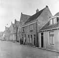
house in Elburg, Netherlands  | |||||
| Upload media | |||||
| Instance of | |||||
|---|---|---|---|---|---|
| Location | Elburg, Gelderland, Netherlands | ||||
| Street address |
| ||||
| Located on street |
| ||||
| Heritage designation |
| ||||
 | |||||
|
This is a category about rijksmonument number 14728
|
| Address |
|
Media in category "Ellestraat 47, Elburg"
The following 2 files are in this category, out of 2 total.
-
 Elburg - Ellestraat 47 RM14728.JPG 4,320 × 3,240; 1.64 MB
-
 Overzicht - Elburg - 20068935 - RCE.jpg 1,200 × 1,177; 308 KB
