Category:Ellestraat 27, Elburg
Jump to navigation
Jump to search
| Object location | | View all coordinates using: OpenStreetMap |
|---|
 | |||||
| Upload media | |||||
| Instance of |
| ||||
|---|---|---|---|---|---|
| Location | Elburg, Gelderland, Netherlands | ||||
| Street address |
| ||||
| Located on street |
| ||||
| Heritage designation |
| ||||
 | |||||
|
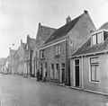
This is a category about rijksmonument number 14721
|
| Address |
|
Media in category "Ellestraat 27, Elburg"
The following 5 files are in this category, out of 5 total.
-
 Elburg- Ellestraat 27.JPG 2,160 × 3,840; 2.65 MB
-
 Exterieur LINKER ZIJGEVEL - Elburg - 20294515 - RCE.jpg 949 × 1,200; 277 KB
-
 Gevel hoek Vispoortstr. - Elburg - 20068933 - RCE.jpg 951 × 1,200; 259 KB
-
 Overzicht - Elburg - 20068934 - RCE.jpg 1,200 × 1,190; 306 KB
-
 Overzicht - Elburg - 20068935 - RCE.jpg 1,200 × 1,177; 308 KB


