Category:Electorate maps of New Zealand in 2014
Jump to navigation
Jump to search
Media in category "Electorate maps of New Zealand in 2014"
The following 71 files are in this category, out of 71 total.
-
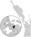
 Auckland Central electorate, 2014.svg 666 × 800; 783 KB
-
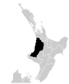
 Bay of Plenty electorate, 2014.svg 666 × 800; 549 KB
-
 Botany electorate, 2014.svg 666 × 800; 783 KB
-
 Christchurch Central electorate, 2014.svg 665 × 800; 579 KB
-
 Christchurch East electorate, 2014.svg 665 × 800; 579 KB
-
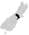
 Clutha-Southland electorate, 2014.svg 665 × 800; 552 KB
-
 Coromandel electorate, 2014.svg 666 × 800; 549 KB
-
 Dunedin North electorate, 2014.svg 665 × 800; 552 KB
-
 Dunedin South electorate, 2014.svg 665 × 800; 552 KB
-
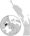
 East Coast Bays electorate, 2014.svg 666 × 800; 783 KB
-
 East Coast electorate, 2014.svg 666 × 800; 549 KB
-
 Epsom electorate, 2014.svg 666 × 800; 783 KB
-
 Hamilton East electorate, 2014.svg 666 × 800; 549 KB
-
 Hamilton West electorate, 2014.svg 666 × 800; 549 KB
-
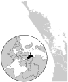
 Hauraki-Waikato electorate, 2014.svg 744 × 1,052; 310 KB
-
 Helensville electorate, 2014.svg 666 × 800; 549 KB
-
 Hunua electorate, 2014.svg 666 × 800; 549 KB
-
 Hutt South electorate, 2014.svg 666 × 800; 605 KB
-
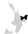
 Ikaroa-Rawhiti electorate, 2014.svg 744 × 1,052; 310 KB
-
 Ilam electorate, 2014.svg 665 × 800; 579 KB
-
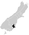
 Invercargill electorate, 2014.svg 665 × 800; 552 KB
-
 Kaikoura electorate, 2014.svg 665 × 800; 552 KB
-
 Kelston electorate, 2014.svg 666 × 800; 783 KB
-
 Mana electorate, 2014.svg 666 × 800; 605 KB
-
 Mangere electorate, 2014.svg 666 × 800; 783 KB
-
 Manukau East electorate, 2014.svg 666 × 800; 783 KB
-
 Manurewa electorate, 2014.svg 666 × 800; 783 KB
-
 Maungakiekie electorate, 2014.svg 666 × 800; 783 KB
-
 Mount Albert electorate, 2014.svg 666 × 800; 783 KB
-
 Mount Roskill electorate, 2014.svg 666 × 800; 783 KB
-
 Napier electorate, 2014.svg 666 × 800; 549 KB
-
 Nelson electorate, 2014.svg 665 × 800; 552 KB
-
 New Lynn electorate, 2014.svg 666 × 800; 783 KB
-
 New Plymouth electorate, 2014.svg 666 × 800; 549 KB
-
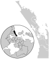 North Shore electorate, 2014.svg 666 × 800; 783 KB
-
 Northcote electorate, 2014.svg 666 × 800; 783 KB
-
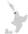
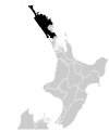 Northland electorate, 2014.svg 666 × 800; 549 KB
-
 Ohariu electorate, 2014.svg 666 × 800; 605 KB
-
 Otaki electorate, 2014.svg 666 × 800; 549 KB
-
 Pakuranga electorate, 2014.svg 666 × 800; 783 KB
-
 Palmerston North electorate, 2014.svg 666 × 800; 549 KB
-
 Papakura electorate, 2014.svg 666 × 800; 783 KB
-
 Port Hills electorate, 2014.svg 665 × 800; 579 KB
-
 Rangitata electorate, 2014.svg 665 × 800; 552 KB
-
 Rangitikei electorate, 2014.svg 666 × 800; 549 KB
-
 Rimutaka electorate, 2014.svg 666 × 800; 605 KB
-
 Rodney electorate, 2014.svg 666 × 800; 549 KB
-
 Rongotai electorate, 2014.svg 666 × 800; 619 KB
-
 Rotorua electorate, 2014.svg 666 × 800; 549 KB
-
 Selwyn electorate, 2014.svg 665 × 800; 552 KB
-
 Tamaki electorate, 2014.svg 666 × 800; 783 KB
-
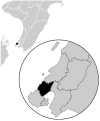
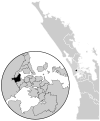
 Tamaki Makaurau electorate, 2014.svg 584 × 836; 406 KB
-
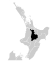
 Taranaki-King Country electorate, 2014.svg 666 × 800; 549 KB
-
 Taupo electorate, 2014.svg 666 × 800; 549 KB
-
 Tauranga electorate, 2014.svg 666 × 800; 549 KB
-
 Te Atatu electorate, 2014.svg 666 × 800; 783 KB
-
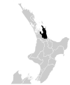
 Te Tai Hauauru electorate, 2014.svg 744 × 1,052; 310 KB
-
 Te Tai Tokerau electorate, 2014.svg 584 × 836; 310 KB
-
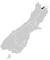
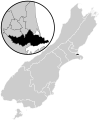
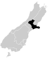
 Te Tai Tonga electorate, 2014.svg 744 × 1,052; 310 KB
-
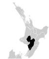
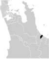
 Tukituki electorate, 2014.svg 666 × 800; 549 KB
-
 Upper Harbour electorate, 2014.svg 666 × 800; 783 KB
-
 Waiariki electorate, 2014.svg 744 × 1,052; 310 KB
-
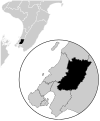
 Waikato electorate, 2014.svg 666 × 800; 549 KB
-
 Waimakariri electorate, 2014.svg 665 × 800; 552 KB
-
 Wairarapa electorate, 2014.svg 666 × 800; 549 KB
-
 Waitaki electorate, 2014.svg 665 × 800; 552 KB
-
 Wellington Central electorate, 2014.svg 666 × 800; 605 KB
-
 West Coast-Tasman electorate, 2014.svg 665 × 800; 552 KB
-
 Whanganui electorate, 2014.svg 666 × 800; 549 KB
-
 Whangarei electorate, 2014.svg 666 × 800; 549 KB
-
 Wigram electorate, 2014.svg 665 × 800; 579 KB


