Category:Election maps of Malappuram district
Jump to navigation
Jump to search
Media in category "Election maps of Malappuram district"
The following 18 files are in this category, out of 18 total.
-

-
 Location of Eranad Legislative Assembly constituency in Kerala.svg 1,510 × 1,782; 1.97 MB
-
 Location of Kondotty Legislative Assembly constituency in Kerala.svg 1,510 × 1,782; 1.97 MB
-
 Location of Kottakkal Legislative Assembly constituency in Kerala.svg 1,510 × 1,782; 1.97 MB
-
 Location of Malappuram Legislative Assembly constituency in Kerala.svg 1,510 × 1,782; 1.97 MB
-
 Location of Manjeri Legislative Assembly constituency in Kerala.svg 1,510 × 1,782; 1.97 MB
-
 Location of Mankada Legislative Assembly constituency in Kerala.svg 1,510 × 1,782; 1.97 MB
-
 Location of Nilambur Legislative Assembly constituency in Kerala.svg 1,510 × 1,782; 1.97 MB
-
 Location of Perinthalmanna Legislative Assembly constituency in Kerala.svg 1,510 × 1,782; 1.97 MB
-
 Location of Ponnani Legislative Assembly constituency in Kerala.svg 1,510 × 1,782; 1.97 MB
-
 Location of Tanur Legislative Assembly constituency in Kerala.svg 1,510 × 1,782; 1.97 MB
-
 Location of Thavanur Legislative Assembly constituency in Kerala.svg 1,510 × 1,782; 1.97 MB
-
 Location of Tirur Legislative Assembly constituency in Kerala.svg 1,510 × 1,782; 1.97 MB
-
 Location of Tirurangadi Legislative Assembly constituency in Kerala.svg 1,510 × 1,782; 1.97 MB
-
 Location of Vallikkunnu Legislative Assembly constituency in Kerala.svg 1,510 × 1,782; 1.97 MB
-
 Location of Vengara Legislative Assembly constituency in Kerala.svg 1,510 × 1,782; 1.97 MB
-
 Location of Wandoor Legislative Assembly constituency in Kerala.svg 1,510 × 1,782; 1.97 MB
-
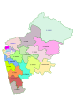 Malappuram district kerala election 2016 map.svg 744 × 1,052; 172 KB
.svg)


