Category:Election maps of Buckinghamshire
Jump to navigation
Jump to search
This category contains election maps for the ceremonial county of Buckinghamshire.
Media in category "Election maps of Buckinghamshire"
The following 52 files are in this category, out of 52 total.
-
 Aylesbury Vale UK local election 2003 map.svg 1,187 × 1,266; 890 KB
-
 Aylesbury Vale UK local election 2007 map.svg 1,187 × 1,266; 889 KB
-
 Aylesbury Vale UK local election 2011 map.svg 1,187 × 1,266; 890 KB
-
 Aylesbury Vale UK local election 2015 map.svg 1,187 × 1,266; 926 KB
-
 Aylesbury Vale UK ward map 2010 (blank).svg 1,187 × 1,266; 889 KB
-
 Aylesbury Vale UK ward map 2015 (blank).svg 1,187 × 1,266; 923 KB
-
 Buckinghamshire County Council election 2013 Map.png 433 × 506; 20 KB
-
 Buckinghamshire County Council election, 2005.svg 1,070 × 1,266; 1.33 MB
-
 Buckinghamshire election 2021 gradient map.svg 1,250 × 1,266; 667 KB
-
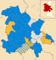
 Buckinghamshire UK local election 2013 map.svg 1,070 × 1,266; 1.15 MB
-
 Buckinghamshire UK local election 2017 map.svg 1,070 × 1,266; 857 KB
-
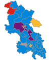
 Buckinghamshire UK local election 2021 map.svg 1,070 × 1,266; 1.15 MB
-
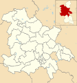
 Buckinghamshire wards 2009.svg 1,070 × 1,266; 1.33 MB
-
 BuckinghamshireParliamentaryConstituency1885Results.svg 758 × 1,403; 38 KB
-
 BuckinghamshireParliamentaryConstituency1886Results.svg 759 × 1,403; 38 KB
-
 BuckinghamshireParliamentaryConstituency1892Results.svg 759 × 1,403; 38 KB
-
 BuckinghamshireParliamentaryConstituency1906Results.svg 759 × 1,403; 38 KB
-
 BuckinghamshireParliamentaryConstituency1918Results.svg 759 × 1,405; 37 KB
-
 BuckinghamshireParliamentaryConstituency1923Results.svg 759 × 1,405; 37 KB
-
 BuckinghamshireParliamentaryConstituency1945Results.svg 756 × 1,404; 39 KB
-
 BuckinghamshireParliamentaryConstituency1950Results.svg 755 × 1,398; 35 KB
-
 BuckinghamshireParliamentaryConstituency1951Results.svg 755 × 1,398; 35 KB
-
 BuckinghamshireParliamentaryConstituency1964Results.svg 755 × 1,398; 35 KB
-
 BuckinghamshireParliamentaryConstituency1970Results.svg 754 × 1,398; 26 KB
-
 BuckinghamshireParliamentaryConstituency1974Results.svg 761 × 1,394; 39 KB
-
 BuckinghamshireParliamentaryConstituency2005Results2.png 200 × 320; 33 KB
-
 BuckinghamshireParliamentaryConstituency2010Results.svg 201 × 343; 58 KB
-
 BuckinghamshireParliamentaryConstituency2010Results2.png 217 × 359; 37 KB
-
 BuckinghamshireParliamentaryConstituency2021Results.png 800 × 1,365; 103 KB
-
 BuckinghamshireParliamentaryConstituency2024Results.svg 244 × 414; 84 KB
-
 Chiltern UK ward map 2010 (blank).svg 1,108 × 1,266; 389 KB
-
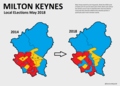 Milton Keynes (42140585915).png 1,796 × 1,282; 128 KB
-
 Milton Keynes Council Election Results Map 2018.svg 1,055 × 1,266; 192 KB
-
 Milton Keynes Council election, 2002.svg 1,055 × 1,266; 371 KB
-
 Milton Keynes Council election, 2003.svg 1,055 × 1,266; 371 KB
-
 Milton Keynes Council election, 2004.svg 1,055 × 1,266; 371 KB
-
 Milton Keynes Council election, 2007.svg 1,055 × 1,266; 371 KB
-
 Milton Keynes Council election, 2008.svg 1,055 × 1,266; 371 KB
-
 Milton Keynes Council election, 2010.svg 1,055 × 1,266; 371 KB
-
 Milton Keynes Council election, 2011.svg 1,055 × 1,266; 371 KB
-
 Milton Keynes Council election, 2012.svg 1,055 × 1,266; 371 KB
-
 Milton Keynes Council election, 2014.svg 1,055 × 1,266; 350 KB
-
 Milton Keynes Council election, 2015.svg 1,055 × 1,266; 350 KB
-
 Milton Keynes Council election, 2016.svg 1,055 × 1,266; 350 KB
-
 Milton Keynes UK local election 2019 map.svg 1,055 × 1,266; 350 KB
-
 Milton Keynes UK local election 2021 map.svg 1,055 × 1,266; 350 KB
-
 Milton Keynes UK ward map 2022.svg 1,055 × 1,266; 349 KB
-
 Milton Keynes UK ward map 2023.svg 1,055 × 1,266; 350 KB
-
 Milton-keynes 2006 election map.png 385 × 480; 59 KB
-
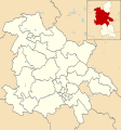
 South Bucks UK ward map 2010 (blank).svg 950 × 1,266; 342 KB
-
 South Bucks UK ward map 2015 (blank).svg 950 × 1,266; 376 KB
-
 Wycombe UK ward map 2010 (blank).svg 1,026 × 1,266; 438 KB


.png)


.svg)
.svg)
.svg)
.svg)
.svg)
.svg)