Category:Elbe bei Ferchland
Jump to navigation
Jump to search
|
Elbe bei Ferchland has an entry on OpenStreetMap (show). |

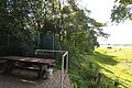
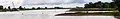
The steep banks of the Elbe  View from the banks of the Elbe | |||||
| Upload media | |||||
| Instance of | |||||
|---|---|---|---|---|---|
| Located in protected area |
| ||||
| Location | |||||
| Located in or next to body of water | |||||
| Length |
| ||||
| Elevation above sea level |
| ||||
 | |||||
Subcategories
This category has the following 3 subcategories, out of 3 total.
Media in category "Elbe bei Ferchland"
The following 19 files are in this category, out of 19 total.
-
 Buhnen an der Elbe in Ferchland (Elbe-Parey) IMG 8900.jpg 4,560 × 3,000; 4.71 MB
-
 Buhnen an der Elbe in Ferchland (Elbe-Parey) IMG 8902.jpg 4,500 × 3,000; 4.04 MB
-
 Elbauen Derben, Dezember 01.jpg 1,701 × 567; 67 KB
-
 Elbauen Derben, Dezember 02.jpg 1,323 × 567; 64 KB
-
 Elbauen Derben, Dezember 03.jpg 3,969 × 567; 236 KB
-
 Elbblick vom Standort der alten Kirche in Ferchland (Elbe-Parey) IMG 8887.jpg 4,500 × 3,000; 3.76 MB
-
 Elbblick vom Standort der alten Kirche in Ferchland (Elbe-Parey) IMG 8889.jpg 4,500 × 3,000; 5.25 MB
-
 Elbe bei Grieben 01.jpg 4,288 × 2,294; 2.43 MB
-
 Elbe bei Grieben 02.jpg 4,288 × 2,099; 3.1 MB
-
 Elbe bei Grieben 03.jpg 27,085 × 2,308; 10.97 MB
-
 Ferchland Elbstraße 01.jpg 854 × 567; 108 KB
-
 Ferchland Elbstraße 02.jpg 756 × 756; 195 KB
-
 Ferchland Elbstraße 03.jpg 756 × 756; 208 KB
-
 Ferchland Elbstraße 04.jpg 1,064 × 567; 196 KB
-
 Ferchländer Steilufer.jpg 1,701 × 567; 123 KB
-
 Fähranleger Grieben 01.jpg 1,323 × 567; 82 KB
-
 Fähranleger Grieben 02.jpg 1,323 × 567; 65 KB
-
 Status Quo II bei Ferchland.jpg 3,494 × 567; 267 KB
-
 Status Quo II.jpg 644 × 520; 194 KB
_IMG_8900.jpg)
_IMG_8902.jpg)

_IMG_8887.jpg)
_IMG_8889.jpg)


