Category:El Manganell (Calders)
Jump to navigation
Jump to search
| Object location | | View all coordinates using: OpenStreetMap |
|---|
masia in Calders (Moianès, Catalonia) _-_1.jpg) | |||||
| Upload media | |||||
| Instance of | |||||
|---|---|---|---|---|---|
| Location | Calders, Moianès, Barcelona Province, Catalonia | ||||
| Architectural style | |||||
| Heritage designation |
| ||||
| Different from | |||||
 | |||||
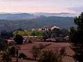
Català: Mas el Manganell. Proper a Colònia Viladecavalls (Calders)
This is a category about a building listed in the Catalan heritage register as Bé Cultural d'Interès Local (BCIL) under the reference IPA-16335. |
Media in category "El Manganell (Calders)"
This category contains only the following file.
-
 Mas el Manganell (Calders) - 1.jpg 1,600 × 1,201; 552 KB