Category:Eikenburg (Eindhoven)
Jump to navigation
Jump to search
| Object location | | View all coordinates using: OpenStreetMap |
|---|
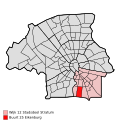
neighborhood in Eindhoven, the Netherlands | |||||
| Upload media | |||||
| Instance of | |||||
|---|---|---|---|---|---|
| Location | Kortonjo, Stratum, North Brabant, Netherlands | ||||
 | |||||
|
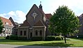
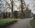
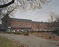
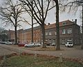
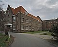
This is a category about rijksmonumentcomplex number 518706
|
Klooster:
|
This is a category about rijksmonument number 518707
|
Ruiterstandbeeld:
|
This is a category about rijksmonument number 518708
|
| Address |
|
Subcategories
This category has the following 3 subcategories, out of 3 total.
Media in category "Eikenburg (Eindhoven)"
The following 24 files are in this category, out of 24 total.
-
 Eikenburg Rijksmonument518707.jpg 3,484 × 2,035; 2.26 MB
-
 Eindhoven Beeldengroep Kanunnik PJ.Triest Henk Oddens 2007.jpg 2,900 × 3,867; 6.74 MB
-
 Eindhoven Beeldengroep Kanunnik PJ.Triest Henk Oddens tekst.jpg 2,921 × 4,030; 5.29 MB
-
 Eindhoven kruis op kapel Eikenburg.jpg 2,907 × 3,876; 4.54 MB
-
 Eindhoven Maria beeld Eikenburg Aalsterweg289.jpg 2,784 × 3,712; 4.55 MB
-
 Eindhoven relief OL Vrouw altijddurende bijstand Eikenburg.jpg 2,248 × 2,997; 2.86 MB
-

-
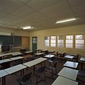 Interieur klaslokaal - Eindhoven - 20336633 - RCE.jpg 1,200 × 1,200; 208 KB
-
 Interieur klaslokaal - Eindhoven - 20336634 - RCE.jpg 1,200 × 956; 208 KB
-
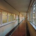 Interieur, overzicht gang, in schoolgedeelte - Eindhoven - 20336635 - RCE.jpg 1,200 × 1,200; 210 KB
-
 Interieur, overzicht gang, in schoolgedeelte - Eindhoven - 20336636 - RCE.jpg 1,200 × 1,200; 188 KB
-
 Interieur, trap in het schoolgedeelte - Eindhoven - 20336630 - RCE.jpg 956 × 1,200; 135 KB
-
 Interieur, trap in het schoolgedeelte - Eindhoven - 20336631 - RCE.jpg 1,200 × 1,200; 167 KB
-
 Interieur, trap in het schoolgedeelte - Eindhoven - 20336632 - RCE.jpg 1,200 × 1,200; 148 KB
-
-
 Noordgevel - Eindhoven - 20336621 - RCE.jpg 1,200 × 956; 261 KB
-
 Noordgevel met omgeving - Eindhoven - 20336611 - RCE.jpg 1,200 × 956; 366 KB
-
 Oostgevel met omgeving - Eindhoven - 20336619 - RCE.jpg 1,200 × 956; 344 KB
-
 Oostgevel met parkeergelegenheid - Eindhoven - 20336620 - RCE.jpg 1,200 × 956; 350 KB
-
 Uitbouw aan westgevel - Eindhoven - 20336614 - RCE.jpg 1,200 × 956; 240 KB
-
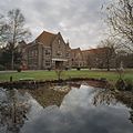 Westgevel en vijver - Eindhoven - 20336612 - RCE.jpg 1,200 × 1,200; 340 KB
-
 Zuidgevel - Eindhoven - 20336623 - RCE.jpg 1,200 × 956; 410 KB
-
 Zuidgevel met omgeving - Eindhoven - 20336617 - RCE.jpg 1,200 × 956; 396 KB
-
 Zuidoostgevel met omgeving - Eindhoven - 20336618 - RCE.jpg 1,200 × 956; 394 KB


