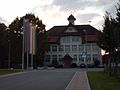
Category:Ehemaliges Schulhaus (Hauptstrasse 15, Unterentfelden)
Jump to navigation
Jump to search
| Object location | | View all coordinates using: OpenStreetMap |
|---|
public building in Unterentfelden in the canton of Aargau, Switzerland  | |||||
| Upload media | |||||
| Instance of | |||||
|---|---|---|---|---|---|
| Part of | |||||
| Location | Unterentfelden, Aarau District, Aargau, Switzerland | ||||
| Street address |
| ||||
| Heritage designation |
| ||||
| Inception |
| ||||
 | |||||
Media in category "Ehemaliges Schulhaus (Hauptstrasse 15, Unterentfelden)"
The following 3 files are in this category, out of 3 total.
-
 Gemeindehaus in Unterentfelden.jpg 3,346 × 2,524; 5.17 MB
-
 Gemeindehaus Unterentfelden.jpg 2,560 × 1,920; 465 KB
-
 Unterentfelden Gemeindehaus 2015-02-20.jpg 4,384 × 2,466; 3.65 MB

