Category:Ehemaliges Kinderheim (Habstangenweg 8, Mümliswil)
Jump to navigation
Jump to search
| Object location | | View all coordinates using: OpenStreetMap |
|---|
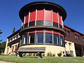
home building in Mümliswil-Ramiswil in the canton of Solothurn, Switzerland  | |||||
| Upload media | |||||
| Instance of | |||||
|---|---|---|---|---|---|
| Part of | |||||
| Location | Mümliswil, Mümliswil-Ramiswil, Thal District, Thal-Gäu, Solothurn, Switzerland | ||||
| Street address |
| ||||
| Heritage designation | |||||
 | |||||
Media in category "Ehemaliges Kinderheim (Habstangenweg 8, Mümliswil)"
This category contains only the following file.
-
 2016 Gedenkstätte Mümliswil.jpg 640 × 480; 124 KB