Category:Ehemaliger Gasthof Linde (Dorfstrasse 23, Reichenbach im Kandertal)
Jump to navigation
Jump to search
| Object location | | View all coordinates using: OpenStreetMap |
|---|
| NO WIKIDATA ID FOUND! Search for Ehemaliger Gasthof Linde (Dorfstrasse 23, Reichenbach im Kandertal) on Wikidata | |
| Upload media |
Media in category "Ehemaliger Gasthof Linde (Dorfstrasse 23, Reichenbach im Kandertal)"
This category contains only the following file.
-
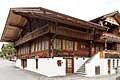 Reichenbach i. K., Dorfstrasse 23.jpg 2,560 × 1,707; 3.23 MB
