Category:Ehemalige Untervogtei, Hottwil
Jump to navigation
Jump to search
| Object location | | View all coordinates using: OpenStreetMap |
|---|
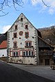
building in Hottwil in the canton of Aargau, Switzerland  | |||||
| Upload media | |||||
| Instance of | |||||
|---|---|---|---|---|---|
| Part of | |||||
| Location | Hottwil, Mettauertal, Laufenburg District, Aargau, Switzerland | ||||
| Street address |
| ||||
| Heritage designation | |||||
| Inception |
| ||||
 | |||||
Media in category "Ehemalige Untervogtei, Hottwil"
The following 2 files are in this category, out of 2 total.
-
 2018-Hottwil-Untervogtei.jpg 1,920 × 1,280; 2.26 MB
-
 Mettauertal Hottwil 064.jpg 2,592 × 3,888; 3.16 MB
