Category:Ehemalige Stickereifabrik, Dorfhalde 138 (Lutzenberg)
Jump to navigation
Jump to search
| Object location | | View all coordinates using: OpenStreetMap |
|---|
building in Lutzenberg in the canton of Appenzell Ausserrhoden, Switzerland  | |||||
| Upload media | |||||
| Instance of | |||||
|---|---|---|---|---|---|
| Part of | |||||
| Location |
| ||||
| Street address |
| ||||
| Heritage designation | |||||
 | |||||
Media in category "Ehemalige Stickereifabrik, Dorfhalde 138 (Lutzenberg)"
The following 2 files are in this category, out of 2 total.
-
 Dorfhalde 138.jpg 3,000 × 2,597; 5.41 MB
-
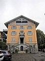 Lutzenberg Dorfhalde 138.jpg 3,455 × 4,607; 1.89 MB
