Category:Eglise St-Ferréol-et-Ferjeux (Sur la Place 80, Damphreux)
Jump to navigation
Jump to search
| Object location | | View all coordinates using: OpenStreetMap |
|---|
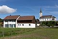
church building in Damphreux in the canton of Jura, Switzerland  | |||||
| Upload media | |||||
| Instance of | |||||
|---|---|---|---|---|---|
| Part of | |||||
| Named after | |||||
| Location | Damphreux, Damphreux-Lugnez, Porrentruy District, Jura, Switzerland | ||||
| Street address |
| ||||
| Heritage designation | |||||
| Inception |
| ||||
 | |||||
Media in category "Eglise St-Ferréol-et-Ferjeux (Sur la Place 80, Damphreux)"
The following 4 files are in this category, out of 4 total.
-
 2016-Damphreux-Eglise-2.jpg 540 × 540; 362 KB
-
 2016-Damphreux-Eglise.jpg 1,920 × 1,280; 2.5 MB
-
 2016-Damphreux-St-Agnes.jpg 1,280 × 1,920; 2.57 MB
-
 ArCJ - Damphreux, Eglise et cure - 137 J 810 a.tif 5,907 × 4,691; 52.88 MB

