Category:Egger Viadukt
Jump to navigation
Jump to search
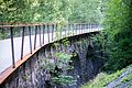
Deutsch: Egger Viadukt (ca. 527 m.ü.M.) der ehemaligen Bregenzerwaldbahn in der Gemeinde Egg (Vorarlberg, Österreich) in der Nähe der Bregenzer Ache. Nun ein Wander- und Fahrradeweg (Achtalweg). Etwa 110 Meter lang.
English: „Egger Viadukt“ (approx. 527 masl) of the former Bregenzerwaldbahn (Railway) in the municipality of Egg (Vorarlberg, Austria) near the Bregenzer Ache (river). Now a hiking- and bicycle path (Achtalweg). About 110 meters long.
Ab: «Egger Viadukt» (environ 527 mètres d'altitude) de l'ancienne Bregenzerwaldbahn (chemin de fer) dans la municipalité de Egg (Vorarlberg, Autriche) dans le Bregenzer Ache (rivière). Maintenant une piste de randonnée et de vélo (Achtalweg). Environ 110 mètres de long.
| Object location | | View all coordinates using: OpenStreetMap |
|---|
Viaduct of the former Bregenzerwaldbahn in the municipality of Egg, Vorarlberg, Austria  | |||||
| Upload media | |||||
| Instance of | |||||
|---|---|---|---|---|---|
| Location | Egg, Bregenz District, Vorarlberg, Austria | ||||
| Elevation above sea level |
| ||||
 | |||||
Media in category "Egger Viadukt"
The following 4 files are in this category, out of 4 total.
-
 Achtal-Former Railway line-Egger Viadukt-01ASD.jpg 4,592 × 3,056; 9.06 MB
-
 Achtal-Former Railway line-Egger Viadukt-03ASD.jpg 4,592 × 3,056; 6.84 MB
-
 Achtalweg im Bregenzerwald 2.JPG 2,500 × 1,669; 4.36 MB
-
 Achtalweg im Bregenzerwald 3.JPG 2,500 × 1,669; 4.17 MB


