Category:Eela Water
Jump to navigation
Jump to search
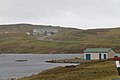
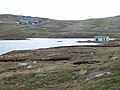
English: Eela Water is a loch in the civil parish of Northmavine, on the island of Mainland, in the council area of the Shetland Islands, Scotland.
lake on Northmavine, North Mainland, Shetland Islands, Scotland, UK | |||||
| Upload media | |||||
| Instance of | |||||
|---|---|---|---|---|---|
| Location | Shetland Islands, Scotland | ||||
 | |||||
Media in category "Eela Water"
The following 15 files are in this category, out of 15 total.
-
 Boat House - geograph.org.uk - 3117650.jpg 1,024 × 683; 172 KB
-
 Boathouse on Eela Water - geograph.org.uk - 3481026.jpg 640 × 480; 65 KB
-
 Eela Water - geograph.org.uk - 1060949.jpg 640 × 480; 53 KB
-
 Eela Water - geograph.org.uk - 3240606.jpg 1,024 × 682; 94 KB
-
 Eela Water - geograph.org.uk - 3240607.jpg 1,024 × 681; 153 KB
-
 Eela Water - geograph.org.uk - 3481038.jpg 640 × 480; 69 KB
-
 Eela Water - geograph.org.uk - 3830555.jpg 640 × 480; 238 KB
-
 Eela Water - geograph.org.uk - 433147.jpg 640 × 480; 118 KB
-
 Eela Water and Ronas Hill - geograph.org.uk - 3240612.jpg 1,024 × 681; 121 KB
-
 North end of Eela Water - geograph.org.uk - 3240600.jpg 1,024 × 681; 162 KB
-
 Punds Taing, Eela Water - geograph.org.uk - 3240613.jpg 1,024 × 682; 131 KB
-
 West end of Eela Water - geograph.org.uk - 3240614.jpg 1,024 × 681; 130 KB
-
 West end of Eela Water - geograph.org.uk - 3480960.jpg 640 × 480; 66 KB
-
 West end of Eela Water - geograph.org.uk - 3480967.jpg 640 × 480; 70 KB
-
 Works Above Eela Water - geograph.org.uk - 2070059.jpg 2,560 × 1,920; 2.46 MB


