Category:Edington, Wiltshire
Jump to navigation
Jump to search
village and civil parish in Wiltshire, England, UK  | |||||
| Upload media | |||||
| Instance of | |||||
|---|---|---|---|---|---|
| Location | Wiltshire, South West England, England | ||||
| official website | |||||
 | |||||
Subcategories
This category has the following 2 subcategories, out of 2 total.
C
- Conduit Head, Wiltshire (1 F)
E
Media in category "Edington, Wiltshire"
The following 200 files are in this category, out of 266 total.
(previous page) (next page)-

-
 2010 , Home, home on the range - geograph.org.uk - 2086288.jpg 1,024 × 683; 183 KB
-

-

-

-
 2010 , Road on Tinhead Hill - geograph.org.uk - 2121739.jpg 800 × 686; 157 KB
-
 2010 , The road to Bratton Access Point - geograph.org.uk - 2086305.jpg 1,600 × 999; 433 KB
-
 2010 , Valley near Tinhead Hill - geograph.org.uk - 2121785.jpg 1,600 × 1,067; 682 KB
-
 2010 , Warning sign, Imber Firing Range - geograph.org.uk - 2074283.jpg 800 × 681; 192 KB
-
 2011 , Blooming gorse on Summer Down - geograph.org.uk - 2412420.jpg 4,280 × 2,439; 4.32 MB
-
 2011 , East on Imber Road, MOD range - geograph.org.uk - 2376886.jpg 3,670 × 2,160; 2.72 MB
-
 2011 , Imber Road crossing Summer Down on MOD land - geograph.org.uk - 2412439.jpg 4,752 × 2,559; 4.04 MB
-
 2011 , Looking south from the road to Imber - geograph.org.uk - 2412459.jpg 4,752 × 2,339; 3.78 MB
-
 2011 , North east from Imber Road - geograph.org.uk - 2412683.jpg 4,721 × 2,032; 2.91 MB
-
 2011 , Tank on Imber Range, a little older - geograph.org.uk - 2412669.jpg 2,988 × 2,402; 2.23 MB
-
 A view to the downs - geograph.org.uk - 5249234.jpg 4,320 × 3,240; 2.95 MB
-
 Across the driveway - geograph.org.uk - 5259350.jpg 4,320 × 3,240; 3.38 MB
-
 At the end of Lambourn Lane - geograph.org.uk - 1057419.jpg 640 × 456; 158 KB
-
 At the far end of Cowleaze Lane - geograph.org.uk - 1235841.jpg 640 × 499; 208 KB
-
 B3098 at Edington - geograph.org.uk - 1770178.jpg 640 × 481; 101 KB
-
 B3098 between Edington and Bratton - geograph.org.uk - 3389845.jpg 4,320 × 3,240; 4.84 MB
-
 Barn at Court Farm, Edington - geograph.org.uk - 4994087.jpg 640 × 480; 322 KB
-
 Barns at Upper Baynton Farm - geograph.org.uk - 4994110.jpg 640 × 480; 250 KB
-
 Battered sign - geograph.org.uk - 5251005.jpg 3,240 × 4,320; 5.71 MB
-
 Below the Chalk escarpment - geograph.org.uk - 5117714.jpg 640 × 426; 46 KB
-
 Beyond the end of Cowleaze Lane - geograph.org.uk - 1215008.jpg 640 × 496; 138 KB
-
 Big ploughed field (1) - geograph.org.uk - 5248512.jpg 4,320 × 3,240; 2.66 MB
-
 Big ploughed field (2) - geograph.org.uk - 5248519.jpg 4,320 × 3,240; 3.62 MB
-
 Boreham, observation posts - geograph.org.uk - 5512225.jpg 1,024 × 749; 130 KB
-
 Boreham, warning sign - geograph.org.uk - 5512217.jpg 1,024 × 768; 144 KB
-
 Bratton, track - geograph.org.uk - 5513426.jpg 1,024 × 768; 172 KB
-
 Building, Imber tank ranges - geograph.org.uk - 5084123.jpg 640 × 480; 131 KB
-
 Byway near Bratton - geograph.org.uk - 5071091.jpg 640 × 640; 250 KB
-
 Cattle in Lutcombe Bottom - geograph.org.uk - 4994065.jpg 640 × 480; 311 KB
-

-
 Chieftain tank near Imber - geograph.org.uk - 3190807.jpg 1,200 × 800; 491 KB
-
 Communications mast - geograph.org.uk - 5248286.jpg 3,240 × 4,320; 2.2 MB
-
 Cowleaze Lane - geograph.org.uk - 1057433.jpg 640 × 492; 190 KB
-
 Crossroads near Edington - geograph.org.uk - 1056238.jpg 640 × 480; 147 KB
-
 Dairyhouse Farm - geograph.org.uk - 5249217.jpg 4,320 × 3,240; 3.07 MB
-
 Derelict tank, Imber ranges - geograph.org.uk - 5084101.jpg 640 × 480; 102 KB
-
 Driveway on Westbury Road, Edington - geograph.org.uk - 5772758.jpg 1,990 × 1,454; 1.25 MB
-
 Edendonedb.png 774 × 184; 53 KB
-
 Edington (east) - geograph.org.uk - 888410.jpg 640 × 479; 70 KB
-
 Edington 878 - geograph.org.uk - 3389587.jpg 4,320 × 3,240; 3.81 MB
-
 Edington Farm Shop - geograph.org.uk - 5476376.jpg 1,024 × 768; 153 KB
-
 Edington features (2) - geograph.org.uk - 5259565.jpg 3,240 × 4,320; 3.69 MB
-
 Edington features (3) - geograph.org.uk - 5259606.jpg 3,240 × 4,320; 4.34 MB
-
 Edington features (7) (geograph 6520522).jpg 4,320 × 3,240; 2.83 MB
-
 Edington from Cowleaze Lane - geograph.org.uk - 1057435.jpg 640 × 458; 177 KB
-
 Edington from Lambourn Lane - geograph.org.uk - 1057427.jpg 640 × 512; 165 KB
-
 Edington Hill - geograph.org.uk - 3436.jpg 640 × 480; 59 KB
-
 Edington houses (1) - geograph.org.uk - 5248278.jpg 4,320 × 3,240; 3.6 MB
-
 Edington houses (11) (geograph 6518486).jpg 4,320 × 3,240; 2.37 MB
-
 Edington houses (16) (geograph 6520519).jpg 4,143 × 2,330; 2.4 MB
-
 Edington houses (17) (geograph 6520520).jpg 4,213 × 3,159; 2.84 MB
-
 Edington houses (18) (geograph 6520521).jpg 4,320 × 3,240; 3.22 MB
-
 Edington houses (2) - geograph.org.uk - 5259541.jpg 4,320 × 3,240; 2.33 MB
-
 Edington houses (4) - geograph.org.uk - 5259563.jpg 4,320 × 3,240; 3.49 MB
-
 Edington houses (5) - geograph.org.uk - 5259583.jpg 4,320 × 3,240; 3.96 MB
-
 Edington houses (6) (geograph 6495837).jpg 4,223 × 3,167; 2.7 MB
-
 Edington houses (7) (geograph 6495907).jpg 3,240 × 4,320; 2.56 MB
-
 Edington houses (9) (geograph 6510948).jpg 4,320 × 3,240; 3 MB
-
 Edington housess (geograph 5259556).jpg 4,320 × 3,240; 3.16 MB
-
 Edington housess (geograph 6510938).jpg 4,320 × 3,240; 3.61 MB
-
 Edington housess (geograph 6510952).jpg 4,320 × 3,240; 3.12 MB
-
 Edington housess (geograph 6518495).jpg 4,320 × 3,240; 2.75 MB
-
 Edington housess (geograph 6518721).jpg 4,320 × 3,240; 3.13 MB
-
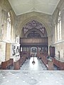
 Edington Priory Church - geograph.org.uk - 5723232.jpg 1,024 × 768; 237 KB
-
 Edington Railway Station (site of) - geograph.org.uk - 888396.jpg 640 × 473; 75 KB
-
 Edington village green - geograph.org.uk - 4994085.jpg 640 × 480; 337 KB
-
 Edington, Ballards Farm - geograph.org.uk - 5513506.jpg 1,024 × 737; 165 KB
-
 Edington, byway - geograph.org.uk - 5723212.jpg 1,024 × 768; 144 KB
-
 Edington, cattle - geograph.org.uk - 5723203.jpg 1,024 × 769; 160 KB
-
 Edington, cattle shed - geograph.org.uk - 5723219.jpg 1,024 × 768; 139 KB
-
 Edington, footpath - geograph.org.uk - 5513512.jpg 768 × 1,024; 240 KB
-
 Edington, former stable - geograph.org.uk - 5513497.jpg 1,024 × 756; 187 KB
-

-
 Edington, Long Hollow - geograph.org.uk - 5723225.jpg 1,024 × 768; 305 KB
-
 Edington, sign - geograph.org.uk - 5723216.jpg 1,024 × 768; 181 KB
-
 Edington, stile - geograph.org.uk - 5723245.jpg 768 × 1,024; 230 KB
-
 Edington, Three Daggers - geograph.org.uk - 5476365.jpg 1,024 × 768; 157 KB
-
 Edington, Wiltshire geograph-3874990-by-Ben-Brooksbank.jpg 2,396 × 1,495; 3.18 MB
-
 End of the road - geograph.org.uk - 5248524.jpg 4,320 × 3,240; 2.54 MB
-
 Farm shed by the Lane - geograph.org.uk - 5248520.jpg 4,320 × 3,240; 3.42 MB
-
 Farmland by the Great Western line - geograph.org.uk - 4628461.jpg 640 × 426; 40 KB
-
 Farmland near Edington - geograph.org.uk - 4770664.jpg 3,060 × 1,181; 644 KB
-
 Farmland near Lower Baynton - geograph.org.uk - 4628465.jpg 640 × 426; 34 KB
-
 Farmland, Lower Baynton - geograph.org.uk - 4876047.jpg 640 × 426; 47 KB
-
 Field and Baynton Hillside Wood - geograph.org.uk - 4028456.jpg 640 × 427; 340 KB
-
 Field at Edington - geograph.org.uk - 4994083.jpg 640 × 480; 337 KB
-

-
 Field near Edington - geograph.org.uk - 5560474.jpg 640 × 383; 43 KB
-
 Field of cattle near Coulston - geograph.org.uk - 4994118.jpg 640 × 481; 271 KB
-
 Field, Lower Baynton - geograph.org.uk - 5193104.jpg 640 × 426; 33 KB
-
 First Great Western HST at Edington - geograph.org.uk - 887537.jpg 640 × 469; 80 KB
-
 Fish pond - geograph.org.uk - 5259378.jpg 4,320 × 3,240; 3.67 MB
-
 Fitzroy Farm, Bratton - geograph.org.uk - 5772309.jpg 1,990 × 1,454; 1.26 MB
-
 Flat farmland - geograph.org.uk - 4628456.jpg 640 × 426; 30 KB
-
 Flat farmland - geograph.org.uk - 4628463.jpg 640 × 426; 38 KB
-
 Follow the path - geograph.org.uk - 5248533.jpg 4,320 × 3,240; 4.18 MB
-
 Footpath at Upper Baynton Farm - geograph.org.uk - 4994103.jpg 640 × 480; 288 KB
-
 Footpath near Upper Baynton Farm - geograph.org.uk - 4994116.jpg 640 × 480; 332 KB
-
 Footpath on Coulston Hill - geograph.org.uk - 4994090.jpg 640 × 480; 247 KB
-
 Gently flows the stream - geograph.org.uk - 5248530.jpg 4,320 × 3,240; 5.36 MB
-
 Grass runway at Westdown Farm - geograph.org.uk - 4994080.jpg 640 × 480; 238 KB
-
 Grassland - geograph.org.uk - 5386112.jpg 640 × 425; 39 KB
-
 Hedge, Edington - geograph.org.uk - 4876039.jpg 640 × 426; 56 KB
-
 Houses on Westbury Road, Edington - geograph.org.uk - 5772314.jpg 2,048 × 1,536; 1.57 MB
-
 HST at Edington - geograph.org.uk - 880351.jpg 640 × 501; 135 KB
-
 HST at Lambourn Lane railway bridge - geograph.org.uk - 1056287.jpg 640 × 507; 265 KB
-
 Bike and military notice, Imber Range - geograph.org.uk - 539093.jpg 640 × 479; 107 KB
-
 Imber, barn ^ containers - geograph.org.uk - 5513400.jpg 1,024 × 768; 143 KB
-
 Imber, Southdown Track - geograph.org.uk - 5513376.jpg 1,024 × 768; 123 KB
-
 Imber, Southdown Track - geograph.org.uk - 5513383.jpg 1,024 × 768; 143 KB
-
 Imber, Southdown Track - geograph.org.uk - 5513419.jpg 1,024 × 768; 222 KB
-
 Imber, track - geograph.org.uk - 5512208.jpg 1,024 × 768; 163 KB
-

-

-
-

-

-

-

-

-

-

-

-

-

-

-

-
-

-

-

-

-

-

-
 Ivy Mill Farm (1) - geograph.org.uk - 5251018.jpg 4,320 × 3,240; 2.54 MB
-
 Ivy Mill Farm (2) - geograph.org.uk - 5251020.jpg 4,320 × 3,240; 2.99 MB
-
 Junction of roads - geograph.org.uk - 5248285.jpg 4,320 × 3,240; 3.91 MB
-
 Junction on Tinhead Hill - geograph.org.uk - 886491.jpg 640 × 450; 59 KB
-
 Lamp post, Edington Priory Church - geograph.org.uk - 2837924.jpg 2,245 × 3,005; 1.3 MB
-
 Landing strip at Westdown Farm - geograph.org.uk - 4994075.jpg 640 × 480; 239 KB
-
 Lane past Westdown Farm - geograph.org.uk - 1235855.jpg 640 × 528; 131 KB
-
 Lines to London (1) - geograph.org.uk - 5248294.jpg 4,320 × 3,240; 3.98 MB
-
 Lines to London (2) - geograph.org.uk - 5259318.jpg 4,320 × 3,240; 3.76 MB
-
 Lines to Plymouth (1) - geograph.org.uk - 5248507.jpg 4,320 × 3,240; 4.23 MB
-
 Lines to Plymouth (2) - geograph.org.uk - 5259306.jpg 4,320 × 3,240; 4.15 MB
-
 Long Hollow, Edington - geograph.org.uk - 1770182.jpg 640 × 493; 91 KB
-
 Luccombe Bottom near Bratton, Wiltshire - geograph.org.uk - 6243910.jpg 2,749 × 2,069; 4.66 MB
-
 Lutcombe Bottom - geograph.org.uk - 4994063.jpg 640 × 480; 286 KB
-
 Market garden - geograph.org.uk - 5259357.jpg 4,320 × 3,240; 3.1 MB
-
 Milestone at Tinhead Edington - geograph.org.uk - 114541.jpg 480 × 640; 143 KB
-
 Military converted containers - geograph.org.uk - 5084143.jpg 640 × 480; 98 KB
-
 Moat at Upper Baynton Fassrm - geograph.org.uk - 4994108.jpg 640 × 480; 382 KB
-

-
 Near Edington - geograph.org.uk - 5386111.jpg 640 × 340; 28 KB
-

-
 Old school house, Edington - geograph.org.uk - 1769823.jpg 640 × 449; 88 KB
-
 Old shelter at Coulston - geograph.org.uk - 4994125.jpg 480 × 640; 469 KB
-
 Orange Hawkweed (Pilosella aurantiacum) - geograph.org.uk - 1017305.jpg 480 × 640; 156 KB
-
 Over the ditch - geograph.org.uk - 5259383.jpg 4,320 × 3,240; 4.96 MB
-
 Pasture near Edington - geograph.org.uk - 4628455.jpg 640 × 426; 31 KB
-
 Pasture near Housecroft Farm - geograph.org.uk - 1050146.jpg 640 × 466; 166 KB
-
 Pasture near Housecroft Farm again - geograph.org.uk - 1056414.jpg 640 × 518; 155 KB
-
 Pasture, Lower Baynton - geograph.org.uk - 5193089.jpg 640 × 426; 31 KB
-
 Path leaves the road - geograph.org.uk - 5248279.jpg 4,320 × 3,240; 4.73 MB
-
 Path leaves the road - geograph.org.uk - 5259338.jpg 4,320 × 3,240; 4.04 MB
-
 Piccadilly Circus in Edington - geograph.org.uk - 5085686.jpg 640 × 480; 72 KB
-
 Picquet Hill - geograph.org.uk - 5084287.jpg 640 × 428; 70 KB
-
 Priory church (1) - geograph.org.uk - 5248276.jpg 4,320 × 3,240; 3.13 MB
-
 Priory church (2) - geograph.org.uk - 5259585.jpg 4,223 × 3,167; 3.29 MB
-
 Priory church (3) - geograph.org.uk - 5259589.jpg 3,166 × 4,221; 2.76 MB
-
 Priory church (4) - geograph.org.uk - 5259593.jpg 3,240 × 4,320; 2.98 MB
-
 Priory church (5) - geograph.org.uk - 5259599.jpg 3,240 × 4,320; 4.7 MB
-
 Priory churchyard (1) - geograph.org.uk - 5248277.jpg 4,320 × 3,240; 4.5 MB
-
 Pumping station - geograph.org.uk - 5259393.jpg 4,320 × 3,240; 3.31 MB
-
 RAF Keevil (1) - geograph.org.uk - 5249228.jpg 4,320 × 3,240; 3.12 MB
-
 RAF Keevil (2) - geograph.org.uk - 5249231.jpg 4,320 × 3,240; 3.37 MB
-
 Railway at Cowleaze Lane - geograph.org.uk - 1050120.jpg 640 × 464; 186 KB
-
 Railway near Edington - geograph.org.uk - 1056270.jpg 640 × 522; 239 KB
-
 Railway near Edington - geograph.org.uk - 114505.jpg 640 × 480; 80 KB
-

-
 Redundant stile - geograph.org.uk - 5249219.jpg 4,320 × 3,240; 3.39 MB
-
 Road down to Imber in Summer Down area - geograph.org.uk - 4153182.jpg 1,600 × 900; 573 KB
-
 Road junction, Edington - geograph.org.uk - 5446117.jpg 1,600 × 1,279; 999 KB
-
 Rough grazing - geograph.org.uk - 5249220.jpg 4,320 × 3,240; 2.38 MB
-
 Salisbury Plain (14) - geograph.org.uk - 5751926.jpg 4,010 × 3,007; 2.39 MB
-
 Salisbury Plain (15) - geograph.org.uk - 5751936.jpg 4,320 × 3,240; 5 MB
-
 Salisbury Plain (16) - geograph.org.uk - 5751938.jpg 4,091 × 3,068; 2.85 MB
-
 Salisbury Plain (17) - geograph.org.uk - 5751943.jpg 4,320 × 3,240; 3.32 MB
-
 Salisbury plain (5) - geograph.org.uk - 5750675.jpg 4,320 × 3,240; 3.28 MB
-
 Salisbury Plain (6) - geograph.org.uk - 5750678.jpg 4,091 × 3,068; 2.34 MB
-
 Salisbury Plain (8) - geograph.org.uk - 5750701.jpg 4,320 × 3,240; 2.14 MB
-
 Sheep pasture near Crossroads Farm - geograph.org.uk - 1053682.jpg 640 × 559; 168 KB
-
 Sign for Pickleberry at Fitzroy Farm, east of Bratton - geograph.org.uk - 5446130.jpg 1,600 × 1,067; 718 KB
-

-


_-_geograph.org.uk_-_5248512.jpg)
_-_geograph.org.uk_-_5248519.jpg)


_-_geograph.org.uk_-_888410.jpg)


_-_geograph.org.uk_-_5259565.jpg)
_-_geograph.org.uk_-_5259606.jpg)
_(geograph_6520522).jpg)


_-_geograph.org.uk_-_5248278.jpg)
_(geograph_6518486).jpg)
_(geograph_6520519).jpg)
_(geograph_6520520).jpg)
_(geograph_6520521).jpg)
_-_geograph.org.uk_-_5259541.jpg)
_-_geograph.org.uk_-_5259563.jpg)
_-_geograph.org.uk_-_5259583.jpg)
_(geograph_6495837).jpg)
_(geograph_6495907).jpg)
_(geograph_6510948).jpg)
.jpg)
.jpg)
.jpg)
.jpg)
.jpg)

_-_geograph.org.uk_-_888396.jpg)


_-_geograph.org.uk_-_5089205.jpg)
_-_geograph.org.uk_-_5089206.jpg)
_-_geograph.org.uk_-_5089208.jpg)
_-_geograph.org.uk_-_5089211.jpg)
_-_geograph.org.uk_-_5089220.jpg)
_-_geograph.org.uk_-_5089212.jpg)
_-_geograph.org.uk_-_5089214.jpg)
_-_geograph.org.uk_-_5089216.jpg)
_-_geograph.org.uk_-_5089218.jpg)
_-_geograph.org.uk_-_5089221.jpg)
_-_geograph.org.uk_-_5089253.jpg)
_-_geograph.org.uk_-_5089257.jpg)
_-_geograph.org.uk_-_5089261.jpg)
_-_geograph.org.uk_-_5089262.jpg)
_-_geograph.org.uk_-_5089269.jpg)
_-_geograph.org.uk_-_5089263.jpg)
_-_geograph.org.uk_-_5089264.jpg)
_-_geograph.org.uk_-_5089265.jpg)
_-_geograph.org.uk_-_5089267.jpg)
_-_geograph.org.uk_-_5089270.jpg)
_-_geograph.org.uk_-_5089271.jpg)
_-_geograph.org.uk_-_5089272.jpg)
_-_geograph.org.uk_-_5251018.jpg)
_-_geograph.org.uk_-_5251020.jpg)


_-_geograph.org.uk_-_5248294.jpg)
_-_geograph.org.uk_-_5259318.jpg)
_-_geograph.org.uk_-_5248507.jpg)
_-_geograph.org.uk_-_5259306.jpg)


_-_geograph.org.uk_-_1017305.jpg)


_-_geograph.org.uk_-_5248276.jpg)
_-_geograph.org.uk_-_5259585.jpg)
_-_geograph.org.uk_-_5259589.jpg)
_-_geograph.org.uk_-_5259593.jpg)
_-_geograph.org.uk_-_5259599.jpg)
_-_geograph.org.uk_-_5248277.jpg)

_-_geograph.org.uk_-_5249228.jpg)
_-_geograph.org.uk_-_5249231.jpg)


_-_geograph.org.uk_-_5751926.jpg)
_-_geograph.org.uk_-_5751936.jpg)
_-_geograph.org.uk_-_5751938.jpg)
_-_geograph.org.uk_-_5751943.jpg)
_-_geograph.org.uk_-_5750675.jpg)
_-_geograph.org.uk_-_5750678.jpg)
_-_geograph.org.uk_-_5750701.jpg)


