Category:Ebchester
Jump to navigation
Jump to search
English: Ebchester is a village in County Durham, in England. It is situated to the north of Consett and to the south east of Whittonstall.
Nederlands: Ebchester is een dorp in het Engelse graafschap Durham. Het ligt ten van Consett en ten zuid-westen van Whittonstall. De parochiekerk, die toegewijd is aan de H. Ebbe de Oude, is deels gebouwd met stenen van de Romeinen. De H. Ebba stichtte hier in de 7de eeuw een dubbelklooster op de plaats van Romeins kamp, op grondgebied dat zij van haar broer Oswiu gekregen had. Het klooster brandde af kort na de dood van Ebba.
village in United Kingdom | |||||
| Upload media | |||||
| Instance of | |||||
|---|---|---|---|---|---|
| Location | County Durham, North East England, England | ||||
 | |||||
Subcategories
This category has the following 3 subcategories, out of 3 total.
E
- St Ebba's church, Ebchester (7 F)
- Ebchester railway station (1 F)
R
- RIB I 1101 (1 F)
Media in category "Ebchester"
The following 75 files are in this category, out of 75 total.
-

-

-

-
 Bauinschrift Coh V Ebchester.png 307 × 146; 51 KB
-
 Bauinschrift Zenturie des Martialis Ebchester.png 302 × 232; 78 KB
-
 Befundskizze Kastell Ebchester.png 1,674 × 1,128; 330 KB
-
 Blossom on Whinney Lane - geograph.org.uk - 4991631.jpg 4,283 × 3,044; 6.67 MB
-
 Bridleway above Ebchester Quarry - geograph.org.uk - 397601.jpg 640 × 480; 78 KB
-

-
 Broadoak Quarry - geograph.org.uk - 1301556.jpg 640 × 427; 111 KB
-
 Broomhill Farm - geograph.org.uk - 4810531.jpg 4,608 × 3,456; 7.04 MB
-
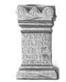 Cocidiusaltar Ebchester.png 187 × 233; 45 KB
-
 Cyclists on the Derwent Walk - geograph.org.uk - 3871668.jpg 640 × 480; 127 KB
-
 Derelict cottage at Ebchester Glebe Farm - geograph.org.uk - 5978881.jpg 4,608 × 3,456; 3.3 MB
-
 Elm Park - geograph.org.uk - 2412970.jpg 3,264 × 2,448; 2.16 MB
-
 Farm buildings at Ebchester - geograph.org.uk - 3901426.jpg 4,608 × 3,456; 6.88 MB
-
 Farmhouse of Mains Farm, Ebchester - geograph.org.uk - 3901412.jpg 4,608 × 3,456; 6.64 MB
-
 Farmyard at Ebchester Glebe - geograph.org.uk - 5978844.jpg 4,439 × 3,329; 3.4 MB
-
 Field gate on Whinny Lane - geograph.org.uk - 4785847.jpg 4,608 × 3,456; 5.61 MB
-
 Fields beside the Derwent Walk - geograph.org.uk - 5621386.jpg 4,608 × 3,456; 4.16 MB
-
 Footpath into Westwood, Ebchester - geograph.org.uk - 2187468.jpg 640 × 480; 81 KB
-
 Glebe Farm, Medomsley Edge - geograph.org.uk - 2509975.jpg 3,264 × 2,448; 1.69 MB
-
 Haugh Wood, Ebchester - geograph.org.uk - 1310472.jpg 640 × 427; 165 KB
-
 High Westwood - geograph.org.uk - 346407.jpg 640 × 426; 110 KB
-
 House on Corbridge Road, Medomsley Edge - geograph.org.uk - 4805465.jpg 4,608 × 3,456; 4.89 MB
-
 Houses at Medomsley Edge - geograph.org.uk - 2510323.jpg 3,264 × 2,448; 1.72 MB
-
 Looking east on Whinny Lane - geograph.org.uk - 2767274.jpg 3,264 × 2,448; 1.77 MB
-
 Looking West from Medomsley Edge - geograph.org.uk - 2510335.jpg 3,264 × 2,448; 1.7 MB
-
 Looking west on Whinny Lane - geograph.org.uk - 2767266.jpg 3,264 × 2,448; 1.68 MB
-
 Medomsley crossroads - geograph.org.uk - 4811577.jpg 4,015 × 2,697; 4.05 MB
-
 Medomsley Edge crossroads - geograph.org.uk - 4414035.jpg 640 × 480; 57 KB
-
 Notice on the footpath to Ebchester - geograph.org.uk - 762498.jpg 640 × 480; 63 KB
-
 Old Blockhouse - geograph.org.uk - 2510002.jpg 3,264 × 2,448; 1.86 MB
-
 Old factory above Ebchester - geograph.org.uk - 397331.jpg 640 × 480; 51 KB
-
 Park Wood, Ebchester - geograph.org.uk - 1301551.jpg 640 × 427; 183 KB
-
 River Derwent - geograph.org.uk - 1551215.jpg 640 × 480; 167 KB
-
 River Derwent Blackhall Mill - geograph.org.uk - 346483.jpg 640 × 426; 150 KB
-
 Rose Terrace, Medomsley Crossroads - geograph.org.uk - 4972162.jpg 4,608 × 3,456; 6.16 MB
-
 The Chelmsford, Ebchester. - geograph.org.uk - 6662.jpg 640 × 480; 106 KB
-
 The Dene - geograph.org.uk - 102950.jpg 640 × 480; 51 KB
-

-
 Top of Whinny Lane - geograph.org.uk - 4927531.jpg 4,608 × 3,456; 5.58 MB
-
 View from east of Cordridge Road, Medomsley Edge - geograph.org.uk - 4067369.jpg 4,608 × 3,456; 5.28 MB
-
 View from the Derwent Walk - geograph.org.uk - 5621387.jpg 4,608 × 3,456; 3.1 MB
-
 View north from behind West View at Medomsley Edge - geograph.org.uk - 4805453.jpg 4,608 × 3,456; 4.9 MB
-
 View north from Whinny Lane - geograph.org.uk - 4927548.jpg 4,608 × 3,456; 5.3 MB
-
 View of the crossroads at Medomsley Edge - geograph.org.uk - 2510308.jpg 3,264 × 2,448; 1.82 MB
-
 View to the west from Whinny Lane - geograph.org.uk - 4991874.jpg 4,608 × 3,456; 6.72 MB
-
 Vitiris Maximus Altar Ebchester.png 746 × 831; 238 KB
-
 Well dressed horse in paddock - geograph.org.uk - 4741854.jpg 1,499 × 964; 1.72 MB
-
 Back of Aged Mineworkers homes Hamsterley - geograph.org.uk - 346455.jpg 640 × 426; 122 KB
-
 Bridge over River Derwent - geograph.org.uk - 1516114.jpg 640 × 480; 123 KB
-

-
 Broad Oak Farm - geograph.org.uk - 640555.jpg 640 × 480; 59 KB
-
 Changing rooms at football ground - geograph.org.uk - 1516140.jpg 640 × 480; 107 KB
-
 Cottages Medomsley - geograph.org.uk - 346568.jpg 640 × 426; 136 KB
-

-
 Ebchester Quarry - geograph.org.uk - 397528.jpg 640 × 480; 60 KB
-
 Ebchester Quarry - geograph.org.uk - 397536.jpg 640 × 480; 62 KB
-

-
 Footbridge over Mill Burn - geograph.org.uk - 640532.jpg 640 × 480; 143 KB
-

-
 Hassockfield STC - geograph.org.uk - 102893.jpg 640 × 480; 57 KB
-
 Newlands South Farm - geograph.org.uk - 396957.jpg 640 × 480; 64 KB
-
 Panshield Hags - geograph.org.uk - 102931.jpg 640 × 480; 45 KB
-

-
 Road to Ebchester from High Westwood - geograph.org.uk - 346420.jpg 640 × 426; 121 KB
-
-
 Springhouse Lane, Ebchester - geograph.org.uk - 397572.jpg 640 × 480; 61 KB
-
 The Cronniwell Village Inn Hamsterley - geograph.org.uk - 346465.jpg 640 × 426; 137 KB
-
 The road from Carr House - geograph.org.uk - 279207.jpg 480 × 640; 128 KB
-
 Tree on Cut Throat Lane - geograph.org.uk - 346430.jpg 640 × 426; 118 KB
-
 Trees and bushes near Black Byerside wood - geograph.org.uk - 346441.jpg 640 × 426; 139 KB
-
 Trees in Chopwell Wood - geograph.org.uk - 103464.jpg 640 × 463; 131 KB
-
 Trees, fence and field near High Westwood - geograph.org.uk - 346413.jpg 640 × 426; 126 KB


