Category:Easton (Bristol ward)
Jump to navigation
Jump to search
electoral ward of the unitary authority of Bristol | |||||
| Upload media | |||||
| Instance of |
| ||||
|---|---|---|---|---|---|
| Location | City of Bristol, South West England, England | ||||
| |||||
Subcategories
This category has the following 4 subcategories, out of 4 total.
Media in category "Easton (Bristol ward)"
The following 53 files are in this category, out of 53 total.
-
 ... and not a drop to drink^ - geograph.org.uk - 6493528.jpg 4,021 × 2,751; 4.4 MB
-
 Approaching Stapledon Road, Bristol - geograph.org.uk - 5570238.jpg 2,914 × 2,151; 649 KB
-
 Auto-elite Bristol on Church Road, Redfield - geograph.org.uk - 6171934.jpg 1,920 × 1,280; 902 KB
-
 Benchmark on wall at rear of ^34 Cooperage Road - geograph.org.uk - 5664581.jpg 657 × 1,024; 254 KB
-

-

-
 Benchmark on ^152 Avondale Road - geograph.org.uk - 5664749.jpg 706 × 1,024; 220 KB
-
 Bristol easton.png 702 × 780; 148 KB
-
 Bristol MMB «61.jpg 2,224 × 1,212; 821 KB
-
 Bristol MMB «91 Lawrence Hill Junction.jpg 2,301 × 1,533; 1.4 MB
-
 Bristol MMB «92 Easton Road.jpg 2,400 × 1,600; 1.51 MB
-
 Bristol MMB «93 Stapleton Road.jpg 2,400 × 1,600; 1.41 MB
-
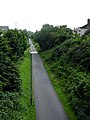 Bristol to Bath Cycle Path - geograph.org.uk - 483428.jpg 480 × 640; 107 KB
-

-
 Bristol, Redfield Former Methodist Church.jpg 640 × 480; 95 KB
-
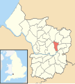 Easton Bristol UK ward map.svg 1,138 × 1,266; 709 KB
-
 Easton Jamia Masjid mosque - geograph.org.uk - 5911481.jpg 4,000 × 3,000; 2.59 MB
-
 Easton Stapleton Road - First 33924 (YX66WKL).JPG 1,366 × 910; 294 KB
-
 Easton Welding ^ Fabrication, Bristol - geograph.org.uk - 5905697.jpg 1,024 × 877; 192 KB
-
 Exit from car park, Stapledon Road Station - geograph.org.uk - 5570226.jpg 3,146 × 2,074; 648 KB
-

-

-
 Former St Matthew's Church, Moorfields, Bristol.jpg 1,024 × 678; 160 KB
-
 Greenbank Road.jpg 500 × 355; 122 KB
-
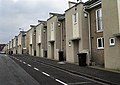
 Houses on Whitehall Road - geograph.org.uk - 6174178.jpg 1,920 × 1,280; 1.01 MB
-
 Hugh llewelyn 221 134 (6702966187).jpg 1,800 × 1,205; 623 KB
-
 Masala Bazaar, 382-386 Stapleton Road, Bristol - geograph.org.uk - 5905580.jpg 1,024 × 619; 115 KB
-
 Mural, Anstey Street, Bristol - geograph.org.uk - 5574941.jpg 1,425 × 1,595; 179 KB
-
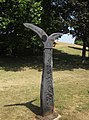 NCN Millennium Milepost MP1084 Bristol.jpeg 1,600 × 2,152; 2.75 MB
-
 Nethambridge.JPG 2,576 × 1,952; 1.32 MB
-
 Nethamlock.JPG 2,576 × 1,952; 1.54 MB
-

-
 On-street parking, Berwick Road, Easton, Bristol - geograph.org.uk - 5905635.jpg 1,024 × 888; 188 KB
-
 Pangolin mural, Robert Street, Easton, Bristol - geograph.org.uk - 5905680.jpg 776 × 1,024; 154 KB
-
 Playing Field - geograph.org.uk - 6493502.jpg 3,696 × 2,596; 3.3 MB
-

-

-

-
 Robert Street, Easton, Bristol - geograph.org.uk - 5905665.jpg 1,024 × 758; 133 KB
-
 Running Track - geograph.org.uk - 6493498.jpg 3,695 × 2,444; 4.2 MB
-
 Russell Town Avenue, Upper Easton - geograph.org.uk - 6174179.jpg 1,920 × 1,280; 1.85 MB
-
 Sports Ground - geograph.org.uk - 6493495.jpg 4,896 × 3,264; 5.77 MB
-
 St Mark's Church House - geograph.org.uk - 5911484.jpg 2,999 × 4,000; 3.16 MB
-
 Stuart St, Redfield, Bristol - geograph.org.uk - 6406889.jpg 1,797 × 1,198; 401 KB
-
 Whitehall Road, Upper Easton - geograph.org.uk - 6170332.jpg 1,920 × 1,280; 1.24 MB
-
 Yasmin's on an Easton corner, Bristol - geograph.org.uk - 5905629.jpg 768 × 1,024; 213 KB
-

-
 Zhyan Restaurant, Easton, Bristol - geograph.org.uk - 5905574.jpg 1,024 × 987; 230 KB
-
 ^126 Avondale Road at York Street junction - geograph.org.uk - 5664655.jpg 1,024 × 683; 144 KB
-
 ^140 Hayward Road at Baden Road junction - geograph.org.uk - 5664818.jpg 1,024 × 669; 151 KB
-
 ^152 Avondale Road at Hanover Street junction - geograph.org.uk - 5664779.jpg 1,024 × 674; 159 KB
-

-
 ^86 Avondale Road - geograph.org.uk - 5664570.jpg 659 × 1,024; 168 KB


_-_geograph.org.uk_-_5664634.jpg)


.JPG)


.jpg)


