Category:Eastern Front maps of World War I
Jump to navigation
Jump to search
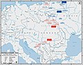
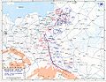
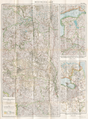
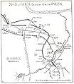
English: Maps showing the military activities on the Eastern Front in Central and Eastern Europe during World War I (1914-1918).
Subcategories
This category has the following 2 subcategories, out of 2 total.
Media in category "Eastern Front maps of World War I"
The following 168 files are in this category, out of 168 total.
-
 02-Westliches Russland (1914).png 9,917 × 11,373; 178.87 MB
-
 07-Das Österreich-Russische Grenzgebiet (1914).png 12,285 × 9,917; 195.72 MB
-
 15-Spezialkarte für den Kriegsschauplatz in Polen (1915).png 9,630 × 13,660; 209.88 MB
-
 16-Karte des Schwarzen Meeres, des Kaukasus und Südrusslands (1914).png 12,082 × 9,917; 166.92 MB
-

-
 17-Karte des russischen Kriegsgebiets zwischen Ostsee und Schwarzem Meer (1915).png 9,917 × 13,387; 183.49 MB
-
 17-Karte des russischen Kriegsgebiets zwischen Ostsee und Schwarzem Meer (1917).png 9,673 × 13,660; 212.92 MB
-
 Eastern Front, 1914.jpg 891 × 690; 524 KB
-
 Masurian Lakes Sep1914.jpg 528 × 364; 51 KB
-
 EasternFront1914a.jpg 1,242 × 961; 175 KB
-
 Karte Weichsel-Nogat-Linie.png 969 × 865; 250 KB
-
 EasternFront1914b-es.svg 992 × 759; 1.83 MB
-
 EasternFront1914b.jpg 1,242 × 961; 229 KB
-
 Ostfront 18021915-es.svg 992 × 759; 1.81 MB
-
 Ostfront 18021915.jpg 1,242 × 961; 201 KB
-
 EasternFront1915b.jpg 1,242 × 961; 181 KB
-
 EasternFront1916a-es.svg 992 × 759; 2.62 MB
-
 EasternFront1916a.jpg 1,242 × 961; 194 KB
-
 Eastern Front As of 1917.jpg 628 × 951; 381 KB
-
 EasternFront1917.jpg 620 × 948; 139 KB
-
 1917-01-20 IBÉRICA 02.jpg 1,765 × 2,823; 1.64 MB
-
 2 bryg korpus 1918.png 2,943 × 1,841; 715 KB
-
 25-Karte von Westkurland, Litauen und Ostpreußen (1915).png 9,917 × 12,811; 172.05 MB
-
 26-Westrussland (1915).png 9,917 × 13,429; 219.19 MB
-
 26. Inf.Div. Polen 1914.jpg 904 × 1,038; 279 KB
-
 31-Die russischen Ostseeprovinzen (1916).png 12,346 × 9,917; 172.57 MB
-
 34-Europäisches Russland (1917).png 9,917 × 12,265; 169.31 MB
-
 35-Karte von Bessarabien und der Moldau (1917).png 9,917 × 12,351; 180.64 MB
-
 39-Litauen, Kurland und Livland (1917).png 9,917 × 12,365; 190.12 MB
-
 41-Südwestrussland (1917).png 8,178 × 13,674; 142.13 MB
-
 42-Spezialkarte des nordischen Kriegsschauplatzes (1918).png 9,673 × 13,674; 184.69 MB
-
 Bitwa pod Gąbinem - 20 VIII 1914 (3).jpg 3,051 × 4,111; 2.72 MB
-
 Gen. Żyliński 1914.jpg 4,411 × 3,783; 1.48 MB
-
 2. Armia 1914.jpg 3,178 × 3,708; 1,023 KB
-
 Prusy Wschodnie 23 VIII 1914.jpg 3,626 × 3,813; 1.28 MB
-
 Wojska 25 VII 1914.jpg 3,066 × 3,939; 1.1 MB
-
 Bitwa pod Tannenbergiem 28 VIII 1914.jpg 3,716 × 3,664; 1.31 MB
-
 Bitwa pod Tannenbergiem 28 VIII-31 VIII 1914.jpg 2,991 × 3,837; 1.09 MB
-
 Bitwa na jeziorach Mazurskich 4 IX-7 IX 1914.jpg 4,629 × 4,800; 1.83 MB
-
 Bitwa na jeziorach Mazurskich 9 IX-12 IX 1914.jpg 3,971 × 4,554; 1.6 MB
-
 Die Ergnisse von 18 bis 26 August.jpg 6,063 × 7,396; 4.74 MB
-
 Die Offensive der Verbündeten im Osten von Mitte Juli bis Ende August 1915.jpg 5,211 × 8,234; 4.41 MB
-
 Inflanty 1915.jpg 2,393 × 3,327; 1.71 MB
-
 Nowo Georgiewsk 1915.jpg 2,393 × 3,327; 1.68 MB
-
 Lage der Armee - Abt. Woyrsch.jpg 3,485 × 2,526; 1.1 MB
-
 Rokitno 1916.jpg 2,520 × 3,483; 1.35 MB
-
 16-20 maja 1915 Austro-Wegry.jpg 1,600 × 1,441; 371 KB
-
 7. L.D. Ukraine 1918.jpg 1,360 × 1,504; 751 KB
-
 7.Ldw.Div 1918 in der Ukraine.jpg 1,371 × 894; 478 KB
-
 Battle of Galicia August 1914 Bitka za Galicijo avgust 1914-es.svg 2,950 × 1,500; 2.34 MB
-
 Battle of Galicia August 1914 Bitka za Galicijo avgust 1914.svg 993 × 507; 568 KB
-
 Battle of Goychay plan.jpg 955 × 863; 294 KB
-
 Battle of Warsaw-Ivangorod. 1914.gif 792 × 1,078; 93 KB
-
 Brenken Litauen 1915.jpg 2,057 × 1,697; 1.44 MB
-
 Map Treaty of Brest-Litovsk-en.jpg 589 × 916; 170 KB
-
 Map Treaty of Brest-Litovsk-ru.svg 595 × 924; 103 KB
-
 Brusilov offensive.jpg 755 × 977; 884 KB
-
 Denikine decomposition1.jpg 464 × 720; 54 KB
-
 Denikine decomposition3.jpg 517 × 664; 51 KB
-
 Denikine decomposition4.jpg 489 × 344; 25 KB
-
 Der östliche Kriegsschauplatz aus der Vogelschau.jpg 12,704 × 8,676; 50.7 MB
-
 Durchbruch im Osten 1915.jpg 659 × 1,255; 342 KB
-
 East Prussian Campaign (17—23 Aug 1914) - ru.svg 2,591 × 1,671; 1.8 MB
-
 East Prussian Campaign (23—26 Aug 1914) - ru.svg 2,591 × 1,671; 1.79 MB
-
 East Prussian Campaign (27—30 Aug 1914) - es.svg 2,591 × 1,671; 1.71 MB
-
 East Prussian Campaign (27—30 Aug 1914) - ru.svg 2,591 × 1,671; 1.7 MB
-
 Eastern Front 1916-8.jpg 800 × 1,110; 212 KB
-
 Eastern front 1916.jpg 800 × 1,071; 277 KB
-
 Eastern front October 1, 1915.jpg 800 × 1,076; 289 KB
-
 Eastern front October 24, 1914.jpg 800 × 1,077; 290 KB
-
 Eastern frontier of Germany (5003803).jpg 4,666 × 5,000; 3.45 MB
-
 EasternFront1916a2.jpg 1,242 × 961; 216 KB
-
 EasternFront1916b.jpg 1,242 × 961; 229 KB
-
 Europa 12 kwietnia 1918.png 611 × 599; 156 KB
-
 FortalezasFronterizasRusas1914.svg 992 × 759; 1.85 MB
-
 FrentesDeGuerradeAustriaHungría1914-1918.svg 1,673 × 1,036; 451 KB
-
 Front russe au 29 juin 1916.jpg 2,029 × 2,497; 794 KB
-
 Füs.Regt 122 1916 Ostfront.jpg 457 × 1,848; 280 KB
-
 Battle for Galicia.jpg 749 × 870; 786 KB
-
 Zayonchkovsky map14.djvu 2,303 × 1,676; 514 KB
-
 Zayonchkovsky map15.djvu 2,510 × 1,734; 581 KB
-
 26. I.D. im Osten Mai 1915.jpg 680 × 1,106; 211 KB
-
 Gumbinnen Rueckzug.jpg 634 × 563; 81 KB
-
 Гумбиненското сражение.JPG 541 × 863; 194 KB
-
 Hutier's Offensive at Riga.jpg 510 × 454; 216 KB
-
 Imperium Germaniae NO.jpg 8,926 × 4,439; 4.06 MB
-
 Imperium Germaniae.jpg 8,926 × 4,439; 5.41 MB
-
 Kaniów 1918.PNG 2,299 × 2,182; 564 KB
-
 Kerensky Offensive, July 1917.svg 993 × 508; 1.17 MB
-
 Zayonchkovsky map16.djvu 1,306 × 1,712; 286 KB
-
 Zayonchkovsky map16.jpg 1,309 × 1,721; 206 KB
-
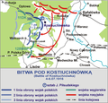 Kostiuchnowka 1916.png 2,317 × 2,212; 1.33 MB
-
 Lage im Osten 1914.jpg 1,079 × 1,414; 525 KB
-
 Legiony 1914-1916.png 1,653 × 2,232; 899 KB
-
 Battle of Lodz.jpg 746 × 1,011; 870 KB
-
 Brenken Angriff Lodz 1914.jpg 1,652 × 1,229; 815 KB
-
 London-geographical-institute the-peoples-atlas 1920 russian-battlefronts.jpg 3,012 × 3,992; 1.97 MB
-
 LPDF 94 carte de l'offensive Broussilov.jpg 920 × 1,179; 467 KB
-
 Map 1917 summer east front campaign.jpg 835 × 934; 431 KB
-
 Map Lithuania 1916 DtVerw B002.jpg 4,385 × 2,326; 1.34 MB
-
 Map of the Balkan Peninsula (5008561).jpg 3,825 × 5,000; 2.98 MB
-
 Map Treaty of Brest-Litovsk-es.svg 595 × 924; 463 KB
-
 Map Treaty of Brest-Litovsk-fr.png 595 × 924; 144 KB
-
 Map Treaty of Brest-Litovsk-fr.svg 595 × 924; 108 KB
-
 Map Treaty of Brest-Litovsk-he.svg 595 × 924; 105 KB
-
 Map Treaty of Brest-Litovsk-lv.svg 595 × 924; 141 KB
-
 Map Treaty of Brest-Litovsk-no.svg 595 × 924; 108 KB
-
 MapOfWWIEasternFrontArea.svg 992 × 759; 698 KB
-
 MapOfWWIEasternFrontAutumn1914-es.svg 992 × 759; 2.43 MB
-
 MapOfWWIEasternFrontAutumn1914.svg 992 × 759; 884 KB
-
 Mitteleuropa ENG Leg wielgórski.PNG 779 × 1,072; 221 KB
-
 Mitteleuropa ENG wielgórski.PNG 779 × 1,072; 212 KB
-
 Mitteleuropa no labels wielgórski.PNG 779 × 1,072; 183 KB
-
 Mitteleuropa POL Leg wielgórski.PNG 779 × 1,072; 211 KB
-
 Mitteleuropa POL wielgórski.PNG 779 × 1,072; 201 KB
-
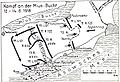 Mius-Bucht 1918.jpg 675 × 459; 183 KB
-
 Mojkovacka bitka.PNG 1,889 × 1,571; 1.98 MB
-
 Oberost1918.PNG 247 × 237; 7 KB
-
 OfensivaBrusílov1.svg 4,319 × 6,702; 1.17 MB
-
 OfensivaBrusílov2.svg 4,319 × 6,702; 1.29 MB
-
 Oktober 1915 im Osten.jpg 816 × 1,456; 468 KB
-
 OkupacjaKP1914-18-es.svg 1,494 × 2,124; 458 KB
-
 OkupacjaKP1914-18.PNG 1,594 × 2,266; 221 KB
-
 Operation Albion, Final Stage (October 17–20, 1917).svg 968 × 1,070; 1.03 MB
-
 Ostfront 1917.jpg 672 × 1,344; 281 KB
-
 Ostfront 1918.jpg 688 × 1,216; 379 KB
-
 Przemysl Map WWI.png 1,324 × 831; 156 KB
-
 Riga Map January 1917 SGW Vol VI.jpeg 1,062 × 1,455; 183 KB
-
 Brenken Rumänien 1916.jpg 1,299 × 841; 487 KB
-
 Russia1918.png 1,098 × 580; 394 KB
-
 Russian retreat 1915-es.svg 1,393 × 2,209; 445 KB
-

-
 Stallupoenen.jpg 303 × 337; 23 KB
-
 Stallupönen.png 797 × 891; 197 KB
-
 BattleOfTannenberg1.jpg 1,242 × 961; 227 KB
-
 Gumbinnen-til-Tannenberg.png 539 × 487; 533 KB
-
 Tannenberg-26-8-1914.jpg 712 × 599; 167 KB
-
 Tannenberg-28-8-1914.jpg 712 × 537; 145 KB
-
 Tannenberg-6-9-1914.jpg 603 × 700; 314 KB
-
 Tannenberg-russisk-plan.jpg 539 × 479; 78 KB
-
 Tannenberg-tysk-plan.jpg 407 × 360; 60 KB
-
 Tannenberg3008.jpg 1,242 × 961; 207 KB
-
 Østprøjsen-terræn.jpg 615 × 481; 77 KB
-
 BattleOfTannenberg2.jpg 1,242 × 961; 205 KB
-
 Battle of Warsaw.jpg 754 × 658; 611 KB
-
 Württ. Verbände Ostfront 1914.jpg 617 × 1,057; 234 KB
-
 Zayonchkovsky map17.djvu 1,727 × 1,692; 385 KB
-
 Zayonchkovsky map23.djvu 2,482 × 1,694; 792 KB
-
 Zayonchkovsky map25.djvu 2,560 × 1,736; 613 KB
-
 Zayonchkovsky map33.djvu 2,279 × 1,691; 579 KB
-
 Zayonchkovsky map35.djvu 2,308 × 1,688; 718 KB
-
 Zayonchkovsky map40.djvu 2,552 × 1,722; 930 KB
-
 Zayonchkovsky map41.djvu 2,631 × 1,784; 796 KB
-
 Zayonchkovsky map55 (part A).png 1,507 × 1,282; 3.62 MB
-
 Августовская операция.png 3,847 × 2,646; 19.61 MB
-
 Варшавская операция 1914.jpg 4,153 × 2,957; 6.36 MB
-
 Великое отступление 1915.jpg 4,125 × 2,937; 6.56 MB
-
 Великое отступление 2.jpg 3,000 × 2,218; 2.37 MB
-
 Галицийская операция 1.png 3,930 × 2,717; 18.09 MB
-
 Галицийская операция 2.png 3,799 × 2,590; 16.96 MB
-
 Галицийская операция 3.png 3,879 × 2,730; 17.86 MB
-
 Галицийская операция 4.png 3,803 × 2,654; 16.45 MB
-
 Горлицкий прорыв.jpg 4,104 × 2,940; 6.58 MB
-
 Карпатская операция 1915.png 3,807 × 2,622; 16.9 MB
-
 Лодзинская операция 1914.png 3,847 × 2,638; 16.35 MB
-
 Перша світова22.png 842 × 686; 1,020 KB
-
 Перша світовааро.png 1,144 × 918; 1.65 MB
-
 Праснышская операция 1915.png 3,811 × 2,654; 16.66 MB
.png)
.png)
.png)
.png)
.png)
.png)
.png)


.png)
.png)

.png)
.png)
.png)
.png)
.png)
.png)
.jpg)


_-_ru.svg)
_-_ru.svg)
_-_es.svg)
_-_ru.svg)


.jpg)


.jpg)


.svg)


.png)


