Category:East Rudham
Jump to navigation
Jump to search
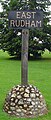
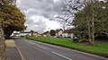
English: East Rudham is a village and civil parish in the English county of Norfolk. It covers an area of and had a population of 525 in 240 households as of the 2001 census.
village and civil parish in Norfolk, United Kingdom  Village green of East Rudham, Norfolk, England  | |||||
| Upload media | |||||
| Instance of | |||||
|---|---|---|---|---|---|
| Location | King's Lynn and West Norfolk, Norfolk, East of England, England | ||||
| Area |
| ||||
 | |||||
Subcategories
This category has the following 6 subcategories, out of 6 total.
B
- Buildings in East Rudham (1 F)
C
- Coxford Priory (2 F)
E
- East Rudham railway station (3 F)
M
R
T
- Transport in East Rudham (1 F)
Media in category "East Rudham"
The following 149 files are in this category, out of 149 total.
-
 Anchorage Barn Veterinary Clinic, East Rudham - geograph.org.uk - 4058031.jpg 1,024 × 565; 351 KB
-
 Approaching East Rudham on the A148 - geograph.org.uk - 6129117.jpg 3,062 × 2,291; 1.83 MB
-
 Ash tree at Rudham - geograph.org.uk - 4561938.jpg 640 × 480; 235 KB
-
 Back Lane, West Rudham - geograph.org.uk - 5150035.jpg 800 × 533; 589 KB
-

-
 Bridleway on the edge of Coxford Wood - geograph.org.uk - 2274918.jpg 2,848 × 2,136; 2.98 MB
-

-
 Broomsthorpe Road East Rudham, Norfolk - geograph.org.uk - 2275083.jpg 2,848 × 2,136; 3.03 MB
-

-
 Church Cottage, East Rudham - geograph.org.uk - 1938177.jpg 480 × 640; 160 KB
-
 Country lane in mid Norfolk - geograph.org.uk - 2274876.jpg 2,848 × 2,136; 3.08 MB
-
 Country lane towards Houghton - geograph.org.uk - 5575696.jpg 640 × 480; 52 KB
-
 Country road crossroads - geograph.org.uk - 5575698.jpg 640 × 480; 58 KB
-
 Coxford Heath in Norfolk - geograph.org.uk - 2313013.jpg 2,848 × 2,136; 2.92 MB
-
 Coxford Wood - geograph.org.uk - 5575681.jpg 640 × 480; 61 KB
-
 Coxford, aerial 2018 - geograph.org.uk - 5835654.jpg 1,024 × 683; 150 KB
-

-
 Crop field towards woodland - geograph.org.uk - 5575694.jpg 640 × 480; 58 KB
-

-
 Croughton Lane west of Tattersett in Norfolk - geograph.org.uk - 2312780.jpg 2,848 × 2,136; 3.12 MB
-
 Dark trees on a country lane - geograph.org.uk - 2275064.jpg 2,848 × 2,136; 3.02 MB
-

-
 Dragon hedge.jpg 533 × 405; 100 KB
-
 East and West Rudham War Memorial - geograph.org.uk - 4890644.jpg 2,484 × 3,219; 1.9 MB
-
 East and West Rudham, aerial 2015 - geograph.org.uk - 4666260.jpg 533 × 800; 102 KB
-
 East Rudham cemetery - geograph.org.uk - 5616235.jpg 3,456 × 2,592; 3.85 MB
-
 East Rudham village green - geograph.org.uk - 4165697.jpg 1,024 × 768; 193 KB
-
 East Rudham Village Green - geograph.org.uk - 5586449.jpg 640 × 480; 99 KB
-
 East rudham village sign - geograph.org.uk - 1567973.jpg 640 × 407; 75 KB
-
 East Rudham village sign - geograph.org.uk - 4561914.jpg 640 × 480; 258 KB
-
 East Rudham Village Sign - geograph.org.uk - 5586442.jpg 480 × 640; 108 KB
-
 East Rudham's village sign.jpg 2,250 × 4,000; 2.49 MB
-
 Empty settlement tanks - geograph.org.uk - 4262960.jpg 640 × 480; 250 KB
-

-
 Entering East Rudham on the A148 - geograph.org.uk - 6129137.jpg 3,755 × 2,754; 3.01 MB
-

-

-

-
 Farm track near Frizzleton Farm - geograph.org.uk - 5575701.jpg 640 × 480; 48 KB
-
 Farm yard in ruins, mid Norfolk - geograph.org.uk - 2274901.jpg 2,848 × 2,136; 3.15 MB
-
 Farmland and copse south of Broomsthorpe, Norfolk - geograph.org.uk - 4268389.jpg 4,320 × 3,240; 5.87 MB
-
 Farmland track near East Rudham's closed station - geograph.org.uk - 4266913.jpg 4,320 × 3,240; 5.53 MB
-
 Farmland, Coxford Heath - geograph.org.uk - 5575687.jpg 640 × 480; 51 KB
-
 Fat sows in Norfolk - geograph.org.uk - 2274952.jpg 2,848 × 2,136; 2.98 MB
-
 Fertiliser spreading north of East Rudham - geograph.org.uk - 2274976.jpg 2,848 × 2,136; 2.84 MB
-
 Field near East Rudham in Norfolk, England.jpg 3,000 × 4,000; 9.01 MB
-
 Field near Frizzleton Farm - geograph.org.uk - 5575697.jpg 640 × 480; 40 KB
-

-
 Flint and sand track in Norfolk - geograph.org.uk - 2600880.jpg 4,320 × 3,240; 5.49 MB
-
 Footpath post with minor damage near East Rudham, Norfolk, England.jpg 3,000 × 4,000; 6.21 MB
-
 Great Massingham disused airfield, aerial 2018 - geograph.org.uk - 5835663.jpg 1,024 × 683; 129 KB
-
 Groveside joining the A148 as it enters East Rudham - geograph.org.uk - 4249735.jpg 4,000 × 3,000; 2.86 MB
-
 Helhoughton 2 miles, straight ahead - geograph.org.uk - 4561980.jpg 640 × 480; 161 KB
-
 Houghton Hall and Park, aerial 2017 - geograph.org.uk - 5523724.jpg 640 × 427; 57 KB
-
 Houghton Hall, aerial 2017 - geograph.org.uk - 5523773.jpg 800 × 533; 75 KB
-
 Houghton Park, aerial 2015 - geograph.org.uk - 4666257.jpg 800 × 438; 60 KB
-
 Houghton Park, aerial 2017 (2) - geograph.org.uk - 5523882.jpg 640 × 427; 50 KB
-
 Houses and barn on The Green - geograph.org.uk - 2274829.jpg 2,848 × 2,136; 2.97 MB
-
 Houses on the village green. East Rudham - geograph.org.uk - 6129194.jpg 3,832 × 2,875; 3.25 MB
-
 In deep shadow - geograph.org.uk - 6230325.jpg 2,000 × 1,333; 1.94 MB
-
-

-
 Just past Syderstone Common - geograph.org.uk - 6230422.jpg 2,000 × 1,333; 1.92 MB
-
 Lane heading south near Coxford Wood - geograph.org.uk - 5575683.jpg 640 × 480; 64 KB
-
 Lane in Coxford Wood - geograph.org.uk - 2391858.jpg 2,848 × 2,136; 2.81 MB
-
 Lane near East Rudham, Norfolk - geograph.org.uk - 2275054.jpg 2,848 × 2,136; 2.93 MB
-
 Lane towards Bagthorpe - geograph.org.uk - 5575699.jpg 640 × 480; 117 KB
-
 Lane towards Bagthorpe - geograph.org.uk - 5575702.jpg 640 × 480; 46 KB
-
 Lane towards Houghton - geograph.org.uk - 5575691.jpg 640 × 480; 67 KB
-
 Lane, Coxford Heath - geograph.org.uk - 5575689.jpg 640 × 480; 49 KB
-
 Leaves on the village green - geograph.org.uk - 1567975.jpg 640 × 427; 73 KB
-
 Middle Bronze Age ceremonial Dirk (FindID 551682).jpg 3,676 × 2,509; 678 KB
-
 MoD Sculthorpe, aerial 2017 - geograph.org.uk - 5523707.jpg 800 × 533; 58 KB
-
 Moss covered bridge and River Tat - geograph.org.uk - 2275145.jpg 2,848 × 2,136; 2.87 MB
-
 On the edge of Boxton Bush Plantation - geograph.org.uk - 2600895.jpg 4,320 × 3,240; 5.42 MB
-
 Onion seedlings - geograph.org.uk - 1389187.jpg 640 × 480; 108 KB
-
 Ordnance Survey Flush Bracket G3201 - geograph.org.uk - 4287125.jpg 4,000 × 3,000; 2.59 MB
-
 Ordnance Survey Flush Bracket G3202 - geograph.org.uk - 4287163.jpg 4,000 × 3,000; 3.59 MB
-
 Ploughing near Syderstone in Norfolk - geograph.org.uk - 2274887.jpg 2,848 × 2,136; 3.01 MB
-
 Pond at Broomsthorpe in Norfolk - geograph.org.uk - 2275120.jpg 2,848 × 2,136; 2.88 MB
-

-
 Primitive Methodist Ebenezer Chapel.jpg 3,000 × 4,000; 3.72 MB
-
 Public footpath near East Rudham, Norfolk - geograph.org.uk - 2275091.jpg 2,848 × 2,136; 3.07 MB
-
 Public footpath sign near East Rudham.jpg 4,000 × 3,000; 9.8 MB
-
 Pumphouses at sewage works - geograph.org.uk - 4262956.jpg 640 × 480; 251 KB
-
 Rape field - geograph.org.uk - 1389200.jpg 640 × 480; 82 KB
-
 Remote undulating lane in the middle of nowhere - geograph.org.uk - 2600851.jpg 4,320 × 3,240; 5.63 MB
-
 Restricted byway north of West Raynham airfield - geograph.org.uk - 4268110.jpg 4,320 × 3,240; 5.43 MB
-
 Road (A148) near The Anchorage - geograph.org.uk - 4249749.jpg 4,000 × 3,000; 2.13 MB
-
 Road junction in village street East Rudham - geograph.org.uk - 6129175.jpg 3,659 × 2,631; 3.06 MB
-
 Road Junction to the South-East of New Buildings - geograph.org.uk - 4249741.jpg 4,000 × 3,000; 2.29 MB
-
 Roses running riot - geograph.org.uk - 1938184.jpg 491 × 640; 233 KB
-
 Rudham CofE Primary Academy.jpg 2,250 × 4,000; 3.68 MB
-
 Rusting gate on Broomsthorpe Road, East Rudham - geograph.org.uk - 2275102.jpg 2,848 × 2,136; 2.98 MB
-
 Sand pit on Coxford Heath, aerial 2018 - geograph.org.uk - 5835624.jpg 1,024 × 683; 127 KB
-

-

-
 Sheep grazing near East Rudham - geograph.org.uk - 4266910.jpg 4,320 × 3,240; 5.75 MB
-
 Shops in East Rudham - geograph.org.uk - 1938167.jpg 640 × 480; 104 KB
-

-
 Signpost to Tatterford - geograph.org.uk - 2275110.jpg 2,848 × 2,136; 3.11 MB
-

-

-

-
 St Mary's church in East Rudham - geograph.org.uk - 1938188.jpg 640 × 480; 108 KB
-
 St Mary's church in East Rudham - geograph.org.uk - 1938191.jpg 480 × 640; 171 KB
-
 St Mary's church in East Rudham - geograph.org.uk - 1938194.jpg 640 × 480; 139 KB
-
 St Mary's Church, East Rudham - geograph.org.uk - 2736503.jpg 4,320 × 3,240; 4.61 MB
-
 Sugar beet heap in mid Norfolk - geograph.org.uk - 2274843.jpg 2,848 × 2,136; 3 MB
-

-

-
 The A148 road through East Rudham - geograph.org.uk - 1938186.jpg 640 × 480; 86 KB
-
 The Church of St Mary at East Rudham - geograph.org.uk - 4249746.jpg 4,000 × 3,000; 3.4 MB
-
 The Crown Inn East Rudham - geograph.org.uk - 6129184.jpg 4,382 × 3,130; 3.7 MB
-
 The Crown Inn, East Rudham - geograph.org.uk - 4058038.jpg 1,024 × 726; 403 KB
-
 The Crown Public House - geograph.org.uk - 2736527.jpg 4,320 × 3,240; 4.94 MB
-
 The Crown Public House.jpg 2,250 × 4,000; 3.29 MB
-

-
 The Green at East Rudham (geograph 7536533).jpg 1,024 × 768; 201 KB
-

-
 The River Tat at Broomsthorpe, Norfolk - geograph.org.uk - 2275133.jpg 2,848 × 2,136; 2.99 MB
-
 The road to Syderstone is on the right - geograph.org.uk - 6230427.jpg 1,851 × 1,194; 481 KB
-
 Track off Station Road, East Rudham - geograph.org.uk - 4266911.jpg 4,320 × 3,240; 5.86 MB
-

-
 Tree plantation north of East Rudham, Norfolk - geograph.org.uk - 2274926.jpg 2,848 × 2,136; 3.2 MB
-
 UK EastRudham.jpg 730 × 1,714; 343 KB
-
 View across the sewage works - geograph.org.uk - 4262963.jpg 640 × 480; 211 KB
-
 View across the valley at East Rudham - geograph.org.uk - 4561942.jpg 640 × 480; 165 KB
-
 Village green of East Rudham, Norfolk, England.jpg 4,000 × 2,250; 5.15 MB
-
 West Rudham, aerial 2017 - geograph.org.uk - 5523691.jpg 800 × 533; 83 KB
-
 White houses near The Green - geograph.org.uk - 2274832.jpg 2,848 × 2,136; 2.95 MB
-
 Anchorage Barn Veterinary Clinic - geograph.org.uk - 413652.jpg 640 × 480; 82 KB
-
 Baling west of Broomsthorpe - geograph.org.uk - 526425.jpg 640 × 480; 108 KB
-

-
-
 Cat and Fiddle, East Rudham - geograph.org.uk - 387970.jpg 640 × 480; 83 KB
-
 East Rudham village sign - geograph.org.uk - 276224.jpg 480 × 640; 94 KB
-
 Farm track, East Rudham, Norfolk - geograph.org.uk - 123782.jpg 640 × 480; 230 KB
-
 Field, East Rudham - geograph.org.uk - 387961.jpg 640 × 480; 88 KB
-
 Landscape, SE of East Rudham, Norfolk - geograph.org.uk - 123786.jpg 640 × 480; 385 KB
-
 Landscape, south of East Rudham, Norfolk - geograph.org.uk - 123784.jpg 640 × 489; 328 KB
-
 Lane near East Rudham - geograph.org.uk - 387984.jpg 640 × 480; 81 KB
-
 Lane to East Rudham Station (disused) - geograph.org.uk - 387971.jpg 640 × 480; 98 KB
-

-
 Pig farm, Coxford Heath - geograph.org.uk - 388008.jpg 640 × 480; 69 KB
-
 Rape field, East Rudham - geograph.org.uk - 387962.jpg 640 × 480; 89 KB
-

-

-


_-_geograph.org.uk_-_5523882.jpg)


.jpg)


_near_The_Anchorage_-_geograph.org.uk_-_4249749.jpg)


.jpg)


_-_geograph.org.uk_-_387971.jpg)


