Category:East End, New Forest
Jump to navigation
Jump to search
human settlement in United Kingdom  | |||||
| Upload media | |||||
| Instance of | |||||
|---|---|---|---|---|---|
| Location | East Boldre, New Forest, Hampshire, South East England, England | ||||
 | |||||
East End is a hamlet in the civil parish of East Boldre, in Hampshire, England. It is about 4 miles (6.5 km) east of Lymington
Subcategories
This category has the following 3 subcategories, out of 3 total.
P
- Pylewell Lake (9 F)
T
- Thorns Beach, Hampshire (7 F)
Media in category "East End, New Forest"
The following 35 files are in this category, out of 35 total.
-
 Boldre Foreshore - geograph.org.uk - 302670.jpg 640 × 480; 85 KB
-

-

-
 Donkeys by the pond, East End, New Forest - geograph.org.uk - 455826.jpg 480 × 640; 107 KB
-
 Cottage, Tanners Lane - geograph.org.uk - 1431819.jpg 640 × 455; 106 KB
-
 East End, drinking ponies - geograph.org.uk - 1376230.jpg 640 × 480; 71 KB
-
 East End, finger post - geograph.org.uk - 1376184.jpg 640 × 480; 68 KB
-
 East End, heathland - geograph.org.uk - 4528965.jpg 1,024 × 768; 158 KB
-
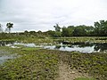
 East End, pond - geograph.org.uk - 1376212.jpg 640 × 480; 93 KB
-
 East End, pond - geograph.org.uk - 4528974.jpg 1,024 × 768; 194 KB
-
 East End, ponies - geograph.org.uk - 1376170.jpg 640 × 480; 61 KB
-
 East End, ponies - geograph.org.uk - 4528969.jpg 1,024 × 768; 129 KB
-
 East End, postbox № SO41 96 - geograph.org.uk - 2489042.jpg 480 × 640; 97 KB
-
 East End, Sheepwash Cottage - geograph.org.uk - 4528982.jpg 1,024 × 768; 143 KB
-

-
 Lilies on the pond, East End, New Forest - geograph.org.uk - 455815.jpg 480 × 640; 103 KB
-
 Low tide, Boldre Foreshore nature reserve - geograph.org.uk - 684107.jpg 640 × 427; 125 KB
-
 Mill Lane Cottage.jpg 4,000 × 3,000; 2.76 MB
-

-
-

-
 Plummers Water at low tide - geograph.org.uk - 683250.jpg 640 × 427; 99 KB
-
 Pond at East End - geograph.org.uk - 3739619.jpg 800 × 450; 225 KB
-

-
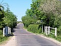
 Road junction at East End, New Forest - geograph.org.uk - 463685.jpg 640 × 427; 62 KB
-

-
 Tanners Lake, Pitts Deep - geograph.org.uk - 591691.jpg 640 × 480; 92 KB
-

-

-

-
 Horsemoor Copse, near East End - geograph.org.uk - 111245.jpg 640 × 427; 127 KB
-
 Oak Tree along Wayfarer's Walk - geograph.org.uk - 62398.jpg 640 × 480; 161 KB
-

-

-
 Pond and road junction at East End - geograph.org.uk - 111250.jpg 640 × 427; 100 KB


.jpg)


.jpg)

