Category:East Dean and Friston
Jump to navigation
Jump to search

civil parish in the Wealden District of East Sussex, England  | |||||
| Upload media | |||||
| Instance of | |||||
|---|---|---|---|---|---|
| Location | Wealden, East Sussex, South East England, England | ||||
| Population |
| ||||
| Area |
| ||||
| official website | |||||
 | |||||
Subcategories
This category has the following 4 subcategories, out of 4 total.
Media in category "East Dean and Friston"
The following 200 files are in this category, out of 994 total.
(previous page) (next page)-
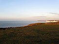
 "New" view at Birling Gap - geograph.org.uk - 3934845.jpg 3,264 × 2,448; 1.13 MB
-
 1, 2 ^ 3, The Green - geograph.org.uk - 4937055.jpg 640 × 426; 79 KB
-
 1, 2 ^ 3, The Green - geograph.org.uk - 4937063.jpg 640 × 426; 76 KB
-
 1-2, Lower Street, East Dean - geograph.org.uk - 3788884.jpg 640 × 480; 70 KB
-
 1-3, The Green, East Dean - geograph.org.uk - 3782814.jpg 640 × 480; 109 KB
-
 1-4, Gilberts Drive, East Dean - geograph.org.uk - 3788888.jpg 640 × 476; 53 KB
-
 1-5, Upper Street, East Dean - geograph.org.uk - 3791325.jpg 640 × 480; 97 KB
-

-
 2014 Rock fall near Birling Gap - geograph.org.uk - 3940553.jpg 4,896 × 3,672; 6.92 MB
-

-

-
 A sheep-related mission - geograph.org.uk - 1916003.jpg 640 × 423; 68 KB
-
 A single tree - geograph.org.uk - 4937128.jpg 640 × 426; 90 KB
-
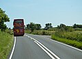
 A259 - geograph.org.uk - 4766981.jpg 640 × 426; 82 KB
-
 A259 - geograph.org.uk - 4766983.jpg 640 × 426; 103 KB
-
 A259 - geograph.org.uk - 4766988.jpg 640 × 426; 66 KB
-
 A259 - geograph.org.uk - 4767196.jpg 640 × 426; 82 KB
-
 A259 - geograph.org.uk - 4915200.jpg 640 × 426; 48 KB
-
 A259 at South Hill, near Friston - geograph.org.uk - 3890580.jpg 1,600 × 1,060; 452 KB
-
 A259 in East Dean - geograph.org.uk - 4907266.jpg 640 × 426; 99 KB
-
 A259 in mist - geograph.org.uk - 2378302.jpg 640 × 430; 53 KB
-
 A259 near Friston - geograph.org.uk - 4924575.jpg 3,264 × 1,840; 1.8 MB
-
 A259 near Gayles Farm - geograph.org.uk - 6180491.jpg 3,565 × 2,675; 2.09 MB
-
 A259 on South Hill - geograph.org.uk - 3060388.jpg 3,264 × 2,448; 4.09 MB
-
 A259 towards Eastbourne - geograph.org.uk - 2841607.jpg 640 × 480; 114 KB
-
 A259, East Dean - geograph.org.uk - 4766978.jpg 640 × 392; 70 KB
-
 A259, East Dean - geograph.org.uk - 4767199.jpg 640 × 466; 58 KB
-
 A259, eastbound - geograph.org.uk - 4767194.jpg 640 × 426; 73 KB
-
 A259, Friston - geograph.org.uk - 4907283.jpg 640 × 480; 118 KB
-
 A259, Friston Hill - geograph.org.uk - 4767198.jpg 640 × 426; 103 KB
-
 A259, Seaford Rd - geograph.org.uk - 4915206.jpg 640 × 426; 67 KB
-
 A259, westbound - geograph.org.uk - 4772888.jpg 640 × 426; 83 KB
-
 A259, westbound - geograph.org.uk - 4907306.jpg 640 × 426; 111 KB
-
 A259, Willingdon Rd junction - geograph.org.uk - 4766985.jpg 640 × 426; 90 KB
-
 Above the Seven Sisters on the South Downs Way - geograph.org.uk - 2192922.jpg 1,024 × 703; 166 KB
-
 Access tower head to the beach at Birling Gap - geograph.org.uk - 4558700.jpg 1,024 × 768; 175 KB
-
 Admiring the View - geograph.org.uk - 2180863.jpg 640 × 480; 88 KB
-
 Allotments, East Dean - geograph.org.uk - 3783757.jpg 640 × 480; 140 KB
-

-
 An old Dovecot^ - geograph.org.uk - 4933814.jpg 640 × 461; 99 KB
-
 Another house has gone at Birling Gap - geograph.org.uk - 4510947.jpg 4,000 × 3,000; 4.19 MB
-
 Appledown, Old Willington Road, Friston - geograph.org.uk - 3763226.jpg 640 × 480; 124 KB
-
 Approaching Birling Gap - geograph.org.uk - 3802069.jpg 2,048 × 1,536; 422 KB
-
 Approaching Birling Gap - geograph.org.uk - 4510138.jpg 4,000 × 3,000; 3.98 MB
-
 Approaching Birling Gap - geograph.org.uk - 4767220.jpg 640 × 426; 53 KB
-
 Approaching Birling Gap - geograph.org.uk - 4767221.jpg 640 × 426; 44 KB
-
 Approaching Crowlink car park, near Friston - geograph.org.uk - 5963469.jpg 1,024 × 768; 1.07 MB
-
 Approaching East Dean - geograph.org.uk - 4215377.jpg 2,592 × 1,944; 1.74 MB
-
 August Bank Holiday 1921^ - geograph.org.uk - 6074891.jpg 1,874 × 1,242; 497 KB
-
 Baily's Hill - geograph.org.uk - 2180800.jpg 460 × 640; 88 KB
-
 Baily's Hill - geograph.org.uk - 3785634.jpg 640 × 415; 41 KB
-
 Baily's Hill - geograph.org.uk - 4333214.jpg 640 × 480; 38 KB
-
 Baily's Hill - geograph.org.uk - 4926758.jpg 3,264 × 1,840; 1.55 MB
-
 Barn at Friston - geograph.org.uk - 3396987.jpg 1,600 × 1,200; 753 KB
-
 Barn Cottage, Crowlink - geograph.org.uk - 3731879.jpg 480 × 640; 85 KB
-
 Barn on Went Hill with a very red roof - geograph.org.uk - 1808066.jpg 2,592 × 1,944; 2.27 MB
-

-
 Barn, Seven Sisters Sheep Centre - geograph.org.uk - 4937100.jpg 640 × 426; 60 KB
-
 Barn, Seven Sisters Sheep Centre - geograph.org.uk - 4937120.jpg 640 × 426; 80 KB
-
 Barn, Seven Sisters Sheep Centre - geograph.org.uk - 4937125.jpg 640 × 426; 57 KB
-
 Barn, Went Hill - geograph.org.uk - 1272570.jpg 640 × 480; 66 KB
-
 Barn, Went Hill - geograph.org.uk - 1272577.jpg 640 × 480; 72 KB
-
 Barns, Birling Farm - geograph.org.uk - 2180990.jpg 640 × 480; 91 KB
-
 Barns, Birling Farm - geograph.org.uk - 3786611.jpg 640 × 480; 59 KB
-
 Barns, Birling Farm - geograph.org.uk - 4937099.jpg 640 × 426; 77 KB
-
 Beach Access, Birling Gap - geograph.org.uk - 3778925.jpg 640 × 480; 55 KB
-
 Beach and Cliffs at Birling Gap - geograph.org.uk - 6536204.jpg 3,648 × 2,736; 3.07 MB
-
 Beach at Birling Gap - geograph.org.uk - 4773739.jpg 640 × 426; 68 KB
-
 Beach at Birling Gap - geograph.org.uk - 4773749.jpg 640 × 449; 73 KB
-
 Beach at Birling Gap - geograph.org.uk - 4773767.jpg 394 × 640; 81 KB
-
 Beach at Birling Gap - geograph.org.uk - 6372591.jpg 5,120 × 3,840; 6.54 MB
-
 Beach near Birling Gap, Sussex - geograph.org.uk - 3617349.jpg 4,320 × 3,240; 4.56 MB
-
 Beach, Birling Gap, Sussex - geograph.org.uk - 4137919.jpg 768 × 1,024; 220 KB
-

-
 Beachy Head Rd - geograph.org.uk - 4773791.jpg 640 × 426; 44 KB
-
 Beachy Head Rd - geograph.org.uk - 4773793.jpg 640 × 426; 59 KB
-
 Beachy Head Rd - geograph.org.uk - 4773795.jpg 640 × 426; 45 KB
-
 Beachy Head Road - geograph.org.uk - 3786573.jpg 640 × 480; 54 KB
-
 Beachy Head Road - geograph.org.uk - 4927170.jpg 3,264 × 1,840; 1.75 MB
-
 Beachy Head Road - geograph.org.uk - 5883283.jpg 640 × 421; 47 KB
-
 Beachy Head Road towards Birling Gap - geograph.org.uk - 3051435.jpg 1,600 × 1,061; 410 KB
-
 Belle Tout - geograph.org.uk - 3778956.jpg 640 × 477; 53 KB
-
 Belle Tout and Hodcombe - geograph.org.uk - 1528115.jpg 640 × 470; 88 KB
-
 Belle Tout Lighthouse - geograph.org.uk - 4944342.jpg 640 × 426; 45 KB
-

-
 Bess Barn-Grey Cottage, East Dean - geograph.org.uk - 3782768.jpg 640 × 480; 110 KB
-
 Between the fourth and fifth - geograph.org.uk - 2004167.jpg 640 × 427; 227 KB
-
 Birling Farm - geograph.org.uk - 3390807.jpg 1,222 × 802; 150 KB
-
 Birling Farm - geograph.org.uk - 3390828.jpg 1,222 × 811; 272 KB
-
 Birling Farm Water Treatment Works - geograph.org.uk - 3786618.jpg 640 × 480; 91 KB
-
 Birling Gap - geograph.org.uk - 3403217.jpg 1,196 × 802; 183 KB
-
 Birling Gap - geograph.org.uk - 3778943.jpg 640 × 480; 46 KB
-
 Birling Gap - geograph.org.uk - 3783833.jpg 640 × 480; 91 KB
-
 Birling Gap - geograph.org.uk - 3849676.jpg 4,815 × 2,756; 4.23 MB
-
 Birling Gap - geograph.org.uk - 4333211.jpg 640 × 480; 37 KB
-
 Birling Gap - geograph.org.uk - 4383190.jpg 800 × 531; 121 KB
-
 Birling Gap - geograph.org.uk - 4944303.jpg 640 × 403; 38 KB
-
 Birling Gap - geograph.org.uk - 4944315.jpg 640 × 426; 34 KB
-
 Birling Gap - geograph.org.uk - 4944320.jpg 640 × 426; 44 KB
-
 Birling Gap and Belle Tout - geograph.org.uk - 3702323.jpg 2,748 × 1,833; 423 KB
-
 Birling Gap and The Seven Sisters - geograph.org.uk - 4558689.jpg 1,024 × 768; 199 KB
-
 Birling Gap Beach - geograph.org.uk - 3783855.jpg 640 × 480; 79 KB
-

-
 Birling Gap cottage and cliff - geograph.org.uk - 3926434.jpg 2,448 × 3,264; 1.47 MB
-
 Birling Gap from Belle Tout - geograph.org.uk - 4938393.jpg 5,345 × 1,363; 1.47 MB
-
 Birling Gap from South Downs Way - geograph.org.uk - 4262695.jpg 4,896 × 3,672; 6.32 MB
-
 Birling Gap from the Seven Sisters - geograph.org.uk - 4938398.jpg 3,624 × 1,372; 844 KB
-
 Birling Gap Hotel - geograph.org.uk - 3778888.jpg 640 × 480; 53 KB
-
 Birling Gap in about 1920 - geograph.org.uk - 3403256.jpg 1,196 × 811; 167 KB
-
 Birling Gap on the South Downs Way - geograph.org.uk - 3340750.jpg 640 × 446; 56 KB
-
 Birling Gap Road - geograph.org.uk - 2640974.jpg 640 × 480; 57 KB
-
 Birling Gap Road - geograph.org.uk - 2641100.jpg 640 × 480; 89 KB
-
 Birling Gap Road - geograph.org.uk - 2841628.jpg 640 × 480; 104 KB
-
 Birling Gap Road - geograph.org.uk - 3137531.jpg 3,264 × 2,448; 5.05 MB
-
 Birling Gap Road - geograph.org.uk - 3778949.jpg 640 × 480; 37 KB
-
 Birling Gap Road - geograph.org.uk - 3786598.jpg 640 × 470; 64 KB
-
 Birling Gap Road - geograph.org.uk - 3786604.jpg 640 × 480; 104 KB
-
 Birling Gap Road - geograph.org.uk - 4767204.jpg 640 × 426; 77 KB
-
 Birling Gap Road - geograph.org.uk - 4767212.jpg 640 × 548; 114 KB
-
 Birling Gap Road - geograph.org.uk - 4767214.jpg 640 × 426; 80 KB
-
 Birling Gap Road - geograph.org.uk - 4767215.jpg 640 × 426; 64 KB
-
 Birling Gap Road - geograph.org.uk - 4767218.jpg 640 × 426; 52 KB
-
 Birling Gap Road - geograph.org.uk - 5883148.jpg 640 × 425; 71 KB
-
 Birling Gap Road - geograph.org.uk - 5952293.jpg 4,000 × 3,000; 4.83 MB
-
 Birling Gap Sewage Farm - geograph.org.uk - 4767217.jpg 640 × 426; 45 KB
-
 Birling Gap Tea Room - geograph.org.uk - 5679349.jpg 3,488 × 2,616; 2.19 MB
-
 Birling Gap ^ Seven Sisters, East Sussex - geograph.org.uk - 5220255.jpg 3,264 × 2,448; 1.66 MB
-

-
 Birling Gap, coastguard cottages on the brink - geograph.org.uk - 6264237.jpg 1,024 × 770; 178 KB
-
-
 Birling Gap, silhouettes on the sand - geograph.org.uk - 4734044.jpg 640 × 480; 87 KB
-
 Birling Gap, westward along Seven Sisters - geograph.org.uk - 4199993.jpg 2,393 × 1,386; 3.99 MB
-
 Birling Manor - geograph.org.uk - 4937123.jpg 640 × 426; 72 KB
-
 Birling Manor - geograph.org.uk - 4937124.jpg 640 × 448; 64 KB
-
 Birling Manor - geograph.org.uk - 5943469.jpg 4,896 × 3,672; 5.83 MB
-
 Birling Manor Farm - geograph.org.uk - 3785613.jpg 640 × 480; 32 KB
-
 Black dog on a green path - geograph.org.uk - 5786727.jpg 4,608 × 3,456; 5.54 MB
-
 Brass Point to Gap Bottom, East Sussex - geograph.org.uk - 4981171.jpg 3,264 × 2,448; 2.86 MB
-
 Brass Point, Seven Sisters, East Sussex - geograph.org.uk - 4899839.jpg 3,264 × 2,448; 2.76 MB
-
 Breakfast Time - geograph.org.uk - 3751011.jpg 640 × 480; 127 KB
-
 Bridleway gate - geograph.org.uk - 4944316.jpg 640 × 426; 59 KB
-
 Bridleway into a dry valley - geograph.org.uk - 4944319.jpg 640 × 426; 58 KB
-
 Bridleway Junction Sign - geograph.org.uk - 5520169.jpg 4,896 × 3,672; 5.75 MB
-
 Bridleway to Birling Farm - geograph.org.uk - 2180932.jpg 640 × 480; 101 KB
-
 Bridleway to Cornish Farm - geograph.org.uk - 4937131.jpg 640 × 426; 54 KB
-
 Bridleway to Cornish Farm - geograph.org.uk - 4944313.jpg 640 × 426; 44 KB
-
 Bridleway to Cornish Farm - geograph.org.uk - 4944340.jpg 640 × 426; 59 KB
-
 Bridleway to Crowlink - geograph.org.uk - 4926714.jpg 3,264 × 1,840; 2.25 MB
-
 Bridleway to Friston Hill - geograph.org.uk - 3048553.jpg 4,000 × 3,000; 3.39 MB
-
 Bridleway to Jevington Road - geograph.org.uk - 3753871.jpg 640 × 480; 153 KB
-
 Bridleway to Willingdon - geograph.org.uk - 3763104.jpg 640 × 480; 49 KB
-
 Bridleway, Friston Forest - geograph.org.uk - 3770819.jpg 640 × 480; 138 KB
-
 Broadchalk, Birling Gap - geograph.org.uk - 3786553.jpg 640 × 484; 61 KB
-

-
 Bus, A259 - geograph.org.uk - 4767193.jpg 640 × 461; 55 KB
-
 Busy Birling Gap - geograph.org.uk - 4773764.jpg 640 × 426; 89 KB
-
 Busy day at the Seven Sisters - geograph.org.uk - 3802067.jpg 2,048 × 1,536; 397 KB
-
 Butchers Trudge car park - geograph.org.uk - 3052776.jpg 4,000 × 3,000; 3.53 MB
-
 Butchershole Bottom - geograph.org.uk - 3753869.jpg 640 × 480; 56 KB
-
 Butchershole Bottom - geograph.org.uk - 5953279.jpg 4,000 × 3,000; 4.87 MB
-
 Butchershole Bottom - geograph.org.uk - 5953280.jpg 4,000 × 3,000; 4.94 MB
-
 Butchershole Bottom - geograph.org.uk - 6300235.jpg 640 × 480; 50 KB
-
 B^B sign, Birling Gap - geograph.org.uk - 3802075.jpg 2,048 × 1,536; 483 KB
-
 Cafe at Birling Gap - geograph.org.uk - 3917089.jpg 4,896 × 3,672; 6.82 MB
-
 Cafe at Birling Gap - geograph.org.uk - 4773728.jpg 640 × 426; 65 KB
-
 Cafe ^ Delicatessen, East Dean - geograph.org.uk - 4937039.jpg 640 × 426; 62 KB
-
 Camping in 1921 - geograph.org.uk - 6075648.jpg 2,218 × 1,684; 480 KB
-
 Car park entrance at Birling Gap - geograph.org.uk - 5883284.jpg 640 × 446; 53 KB
-
 Car Park, Birling Gap - geograph.org.uk - 3778936.jpg 640 × 480; 37 KB
-
 Car park, Birling Gap - geograph.org.uk - 4773786.jpg 640 × 426; 57 KB
-
 Carew Cottages, East Dean - geograph.org.uk - 3782845.jpg 640 × 491; 133 KB
-
 Carline Thistle - Carlina vulgaris - geograph.org.uk - 2345773.jpg 2,592 × 1,944; 2.1 MB
-
 Cars parked at Birling Gap - geograph.org.uk - 5883285.jpg 640 × 480; 76 KB
-

-
 Caves at Brass Point, Seven Sisters, East Sussex - geograph.org.uk - 4900810.jpg 3,264 × 2,448; 2.82 MB
-
 Chalk Cliff - geograph.org.uk - 4773760.jpg 426 × 640; 90 KB
-
 Chalk cliffs - geograph.org.uk - 4773743.jpg 426 × 640; 90 KB
-
 Chalk cliffs - geograph.org.uk - 4773744.jpg 426 × 640; 91 KB
-
 Chalk cliffs - geograph.org.uk - 4773745.jpg 426 × 640; 76 KB
-
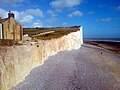 Chalk Cliffs at Birling Gap - geograph.org.uk - 5022387.jpg 4,160 × 3,120; 4.19 MB
-
 Chalk Cliffs at Birling Gap - geograph.org.uk - 5084008.jpg 4,896 × 3,672; 6.5 MB
-
 Chalk Cliffs at Birling Gap - geograph.org.uk - 5144349.jpg 4,890 × 3,128; 4.22 MB
-
 Chalk Cliffs at Birling Gap - geograph.org.uk - 5310929.jpg 4,896 × 3,672; 5.48 MB
-
 Chalk Cliffs at Birling Gap - geograph.org.uk - 5310933.jpg 4,896 × 3,672; 5.83 MB
-
 Chalk Cliffs at Birling Gap - geograph.org.uk - 5441698.jpg 4,608 × 3,456; 1.67 MB
-
 Chalk Cliffs, Birling Gap - geograph.org.uk - 5682825.jpg 4,884 × 3,073; 6.58 MB
-
 Chalk cliffs, Seven Sisters, view east to south-east - geograph.org.uk - 3802063.jpg 2,048 × 1,536; 416 KB
-
 Chalk cliffs, Seven Sisters, view west to north-west - geograph.org.uk - 3802061.jpg 2,048 × 1,536; 439 KB
-
 Chalk dry valley - geograph.org.uk - 4944327.jpg 640 × 426; 52 KB
-
 Chalk grassland - geograph.org.uk - 4767205.jpg 640 × 426; 45 KB
-
 Chalk grasslands - geograph.org.uk - 4933712.jpg 640 × 426; 39 KB
-
 Chalk scenery - geograph.org.uk - 4944325.jpg 640 × 426; 58 KB
-
 Church at Friston - geograph.org.uk - 5786713.jpg 4,608 × 3,456; 4.11 MB
-
 Church of St Mary - geograph.org.uk - 4907295.jpg 640 × 426; 117 KB
-
 Church of St Mary, Friston - geograph.org.uk - 5675508.jpg 4,896 × 3,672; 5.95 MB
-
 Church of St Simon and St Jude - geograph.org.uk - 4933822.jpg 640 × 426; 84 KB
-
 Church of St Simon and St Jude - geograph.org.uk - 4937032.jpg 640 × 426; 110 KB
-
 Church of St Simon and St Jude - geograph.org.uk - 4937065.jpg 640 × 426; 82 KB
-
 Church of St Simon and St Jude - geograph.org.uk - 4937068.jpg 640 × 426; 96 KB
-
 Church of St Simon and St Jude, East Dean - geograph.org.uk - 4164259.jpg 4,896 × 3,672; 6.18 MB


