Category:Dvor Mikuláš
Jump to navigation
Jump to search
| Object location | | View all coordinates using: OpenStreetMap |
|---|
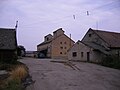
Dvor Mikuláš (Hungarian: Szentmiklóspuszta) is a part of the Dubník (Hungarian: Csúz) municipality.
Media in category "Dvor Mikuláš"
The following 15 files are in this category, out of 15 total.
-
 Csúz013.JPG 1,600 × 1,200; 407 KB
-
 Csúz014.JPG 1,600 × 1,200; 445 KB
-
 Csúz015.JPG 1,600 × 1,200; 450 KB
-
 Csúz016.JPG 1,600 × 1,200; 535 KB
-
 Csúz017.JPG 1,600 × 1,200; 543 KB
-
 Csúz018.JPG 1,600 × 1,200; 483 KB
-
 Csúz019.JPG 1,600 × 1,200; 520 KB
-
 Csúz020.JPG 1,200 × 1,600; 465 KB
-
 Csúz021.JPG 1,600 × 1,200; 439 KB
-
 Csúz022.JPG 1,600 × 1,200; 416 KB
-
 Csúz023.JPG 1,200 × 1,600; 401 KB
-
 Csúz024.JPG 1,600 × 1,200; 424 KB
-
 Csúz025.JPG 1,600 × 1,200; 435 KB
-
 Csúz026.JPG 1,600 × 1,200; 397 KB
-
 Csúz12.JPG 1,600 × 1,200; 356 KB


