Category:Dunne Bierkade 18, The Hague
Jump to navigation
Jump to search
| Object location | | View all coordinates using: OpenStreetMap |
|---|
building in The Hague, Netherlands  | |||||
| Upload media | |||||
| Instance of | |||||
|---|---|---|---|---|---|
| Location | The Hague, South Holland, Netherlands | ||||
| Street address |
| ||||
| Located on street | |||||
| Architect | |||||
| Commissioned by | |||||
| Heritage designation |
| ||||
 | |||||
|
This is a category about rijksmonument number 17507
|
| Address |
|
Media in category "Dunne Bierkade 18, The Hague"
The following 31 files are in this category, out of 31 total.
-
 Achtergevel - 's-Gravenhage - 20088453 - RCE.jpg 1,190 × 1,200; 371 KB
-
 Bibliotheek - 's-Gravenhage - 20088442 - RCE.jpg 1,195 × 1,200; 295 KB
-
 Bovenlicht in hal - 's-Gravenhage - 20088436 - RCE.jpg 1,197 × 1,200; 220 KB
-
 Den Haag - Dunne Bierkade 18.JPG 1,536 × 2,048; 1.41 MB
-
-
 Deur naar bibliotheek - 's-Gravenhage - 20088443 - RCE.jpg 1,188 × 1,200; 251 KB
-
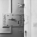 Deurslot van voordeur - 's-Gravenhage - 20088430 - RCE.jpg 1,197 × 1,200; 181 KB
-
 Dunne Bierkade Den Haag.jpg 1,280 × 854; 270 KB
-
 Hal 1e etage - 's-Gravenhage - 20088438 - RCE.jpg 1,190 × 1,200; 253 KB
-
 Hal met trap, parterre - 's-Gravenhage - 20088431 - RCE.jpg 1,197 × 1,200; 185 KB
-
 Ingangspartij - 's-Gravenhage - 20088417 - RCE.jpg 866 × 1,200; 135 KB
-
-
 Kamertje 1e etage - 's-Gravenhage - 20088447 - RCE.jpg 1,195 × 1,200; 230 KB
-
 Kap - 's-Gravenhage - 20088449 - RCE.jpg 1,192 × 1,200; 167 KB
-
 Kelder, pomp in keuken - 's-Gravenhage - 20088451 - RCE.jpg 1,197 × 1,200; 239 KB
-
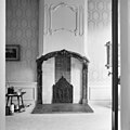
 Kelder, schouw - 's-Gravenhage - 20088450 - RCE.jpg 1,192 × 1,200; 242 KB
-
 Kopje in hal 1e etage - 's-Gravenhage - 20088439 - RCE.jpg 1,190 × 1,200; 186 KB
-
 Plafond in hal op zolder - 's-Gravenhage - 20088441 - RCE.jpg 1,197 × 1,200; 138 KB
-
 Plafond van hal - 's-Gravenhage - 20088432 - RCE.jpg 1,190 × 1,200; 192 KB
-
 Plafond van hal - 's-Gravenhage - 20088433 - RCE.jpg 1,186 × 1,200; 203 KB
-
 RM17507 Den Haag - Dunne Bierkade 18.jpg 2,448 × 3,264; 2.05 MB
-
 Schouw achterkamer parterre - 's-Gravenhage - 20088445 - RCE.jpg 1,195 × 1,200; 240 KB
-
 Schouw in kamer rechts parterre - 's-Gravenhage - 20088444 - RCE.jpg 1,197 × 1,200; 216 KB
-
 Schouw in kamertje links, parterre - 's-Gravenhage - 20088446 - RCE.jpg 1,195 × 1,200; 244 KB
-
 Stucwerk in hal - 's-Gravenhage - 20088434 - RCE.jpg 1,192 × 1,200; 166 KB
-
 Stucwerk in hal - 's-Gravenhage - 20088435 - RCE.jpg 1,192 × 1,200; 174 KB
-
 Trap 1e etage - 's-Gravenhage - 20088437 - RCE.jpg 1,185 × 1,200; 243 KB
-
 Trap en hal op zolder - 's-Gravenhage - 20088440 - RCE.jpg 1,188 × 1,200; 195 KB
-
 Voorgevel - 's-Gravenhage - 20088416 - RCE.jpg 887 × 1,200; 208 KB
-
 Voorgevel - 's-Gravenhage - 20088452 - RCE.jpg 953 × 1,200; 333 KB
-
 Zolderkamer - 's-Gravenhage - 20088448 - RCE.jpg 1,190 × 1,200; 210 KB


