Category:Dunbar Harbour
Jump to navigation
Jump to search
Dunbar Harbour is composed of the Victoria and Cromwell harbour basins.
Subcategories
This category has only the following subcategory.
O
Media in category "Dunbar Harbour"
The following 13 files are in this category, out of 13 total.
-
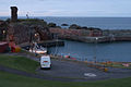
 Dunbar harbour - geograph.org.uk - 1367488.jpg 640 × 411; 97 KB
-
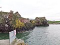
 Dunbar harbour and castle - geograph.org.uk - 727962.jpg 640 × 426; 66 KB
-
 Dunbar Harbour, East Lothian - entrance and castle.jpg 4,608 × 3,456; 4.34 MB
-
 Dunbar Harbour, East Lothian - old Cromwell Harbour and blocked entrance.jpg 4,213 × 2,788; 3.45 MB
-
 Dunbar Harbour, Scotland - OpenStreetMap - January 2021.png 1,388 × 1,196; 888 KB
-
 Dunbar Victoria Harbour, East Lothian.jpg 4,608 × 2,440; 3.29 MB
-
 Dunbar, from Roy Military Survey of Scotland, 1747-1755.png 1,002 × 832; 1.06 MB
-
 Dunbar, from the Ordnance Survey 25-inch to the mile Haddingtonshire VII.5 map, 1894.png 1,294 × 1,086; 2.37 MB
-
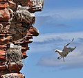 Kittiwakes at Dunbar Harbour (geograph 4503509).jpg 640 × 603; 189 KB
-
 Ordnance Survey Tide Gauge House, Dunbar Harbour, East Lothian - view across entrance.jpg 4,598 × 3,442; 5.47 MB
-
 Ordnance Survey Tide Gauge House, Dunbar Harbour, East Lothian.jpg 4,606 × 3,454; 5.79 MB
-
 Piles of Coloured Creels at Victoria Harbour Dunbar (geograph 5747129).jpg 2,048 × 1,536; 1.05 MB
-
 Saltire in Dunbar Harbour.jpg 519 × 775; 102 KB


.jpg)


.jpg)
