Category:Dummer, Hampshire
Jump to navigation
Jump to search
village and civil parish in Hampshire, United Kingdom  | |||||
| Upload media | |||||
| Instance of | |||||
|---|---|---|---|---|---|
| Location | Basingstoke and Deane, Hampshire, South East England, England | ||||
| Population |
| ||||
| Different from | |||||
 | |||||
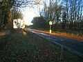
English: Dummer is a parish and village in Hampshire, England located 6 miles south west of Basingstoke, close to the M3 motorway. In the 2001 census it had a population of 643, and the village currently has 127 dwellings. . The name of the village is derived from Dun (meaning hill) and Mer (lake or pond). The English surname 'Dummer' is thought to originate from here, as the Dummer family were lords of the manor between the 12th and 16th centuries.
Português: Dummer é um vilarejo localizado em Hampshire, Inglaterra, a seis milhas de Basingstoke. De acordo com o censo britânico de 2001, o vilarejo tinha uma população de 643 habitantes.
Subcategories
This category has the following 4 subcategories, out of 4 total.
Media in category "Dummer, Hampshire"
The following 200 files are in this category, out of 882 total.
(previous page) (next page)-
 700 yards to the A33-M3 merge - geograph.org.uk - 2184444.jpg 640 × 386; 37 KB
-
 A broad approach to Dummer Grange - geograph.org.uk - 825611.jpg 640 × 480; 78 KB
-
 A hint of green - geograph.org.uk - 1829044.jpg 640 × 480; 77 KB
-
 A pain for the combine - geograph.org.uk - 5286997.jpg 1,024 × 768; 195 KB
-
 A patch of frost - geograph.org.uk - 5286933.jpg 1,024 × 768; 271 KB
-
 A secure Shortwood's Copse - geograph.org.uk - 5500031.jpg 640 × 480; 168 KB
-
 A30 - approaching the M3 - geograph.org.uk - 3268113.jpg 640 × 480; 123 KB
-
 A30 - direction Basingstoke - geograph.org.uk - 3656390.jpg 640 × 458; 81 KB
-
 A30 - west of Basingstoke - geograph.org.uk - 3656441.jpg 640 × 455; 85 KB
-
 A30 approaching Basingstoke - geograph.org.uk - 4303041.jpg 1,024 × 724; 185 KB
-
 A30 by Ganderdown Copse - geograph.org.uk - 3268110.jpg 640 × 480; 113 KB
-
 A30 by Peak Copse - geograph.org.uk - 5499985.jpg 640 × 496; 112 KB
-
 A30 by Southwood Farm - geograph.org.uk - 2764815.jpg 640 × 480; 97 KB
-
 A30 entering Basingstoke - geograph.org.uk - 5499983.jpg 640 × 397; 88 KB
-
 A30 entering Basingstoke - geograph.org.uk - 5499989.jpg 640 × 439; 94 KB
-
 A30 junction - geograph.org.uk - 2366241.jpg 640 × 406; 108 KB
-
 A30 leaving Basingstoke - geograph.org.uk - 2764822.jpg 640 × 480; 96 KB
-
 A30 near The Sun Inn - geograph.org.uk - 3140019.jpg 800 × 530; 83 KB
-
 A30 passing Ganderdown Copse - geograph.org.uk - 6767117.jpg 1,024 × 744; 270 KB
-
 A30 passing Ganderdown Copse - geograph.org.uk - 6767120.jpg 1,024 × 743; 181 KB
-
 A30 to the west - geograph.org.uk - 2366259.jpg 640 × 396; 91 KB
-
 A303 merging with the M3 motorway - geograph.org.uk - 3778453.jpg 1,600 × 1,019; 365 KB
-
 A303 signage - Dummer - geograph.org.uk - 5517688.jpg 640 × 480; 122 KB
-
 A33 and M3 - geograph.org.uk - 1770871.jpg 640 × 428; 145 KB
-
 Access onto Duxford Lane - geograph.org.uk - 6788189.jpg 1,024 × 768; 356 KB
-
 Access road - Wayfarer's Walk - geograph.org.uk - 2765746.jpg 640 × 480; 72 KB
-
 Access to Dummer Golf Club - geograph.org.uk - 3808380.jpg 800 × 553; 222 KB
-
 Access to Dummer Grange - geograph.org.uk - 3443564.jpg 640 × 425; 97 KB
-
 Access to farmland by the M3 - geograph.org.uk - 3210216.jpg 640 × 480; 52 KB
-
 Access to Southwood Farm - geograph.org.uk - 2636845.jpg 640 × 438; 81 KB
-
 Access to Southwood Farm - geograph.org.uk - 2764816.jpg 640 × 480; 123 KB
-
 Access to Southwood Farm - geograph.org.uk - 3210191.jpg 640 × 480; 84 KB
-
 Access to Southwood Farm - geograph.org.uk - 3619757.jpg 640 × 475; 74 KB
-
 Access to Southwood Farm - geograph.org.uk - 3927113.jpg 1,553 × 1,169; 946 KB
-
 Access to Southwood Farm farm yard - geograph.org.uk - 4752242.jpg 1,600 × 1,062; 800 KB
-
 All day frost - geograph.org.uk - 5286954.jpg 1,024 × 768; 328 KB
-
 All Saints Church, Dummer - geograph.org.uk - 4630277.jpg 2,560 × 1,920; 2.02 MB
-
 Already occupied - Saunders Way - geograph.org.uk - 5493149.jpg 640 × 480; 89 KB
-
 Already occupied - Saunders Way - geograph.org.uk - 5493153.jpg 640 × 480; 84 KB
-
 Always a hint of chalk - geograph.org.uk - 2847596.jpg 640 × 480; 69 KB
-
 Always chalk close to the surface - geograph.org.uk - 5332807.jpg 640 × 434; 85 KB
-
 An odd mix of styles - geograph.org.uk - 5493100.jpg 640 × 480; 116 KB
-
 An odd place for a clump of plants - geograph.org.uk - 5499982.jpg 640 × 409; 84 KB
-
 Anaerobic digestion plant - Kennel Farm - geograph.org.uk - 5500059.jpg 640 × 480; 106 KB
-
 Anyone live here^ - geograph.org.uk - 3657335.jpg 640 × 479; 112 KB
-
 Approach to Clump Farm - geograph.org.uk - 2852152.jpg 640 × 425; 79 KB
-
 Approach to Dummer from the north - geograph.org.uk - 3931021.jpg 800 × 600; 156 KB
-
 Approach to Dummer Grange - geograph.org.uk - 3443543.jpg 640 × 425; 81 KB
-
 Approaching Clump Farm - geograph.org.uk - 2366172.jpg 640 × 421; 83 KB
-
 Approaching Dummer Down Farm - geograph.org.uk - 3862064.jpg 1,600 × 1,063; 474 KB
-
 Approaching Dummer Grange - geograph.org.uk - 829574.jpg 640 × 480; 70 KB
-
 Approaching J7, M3 - geograph.org.uk - 5274363.jpg 640 × 409; 52 KB
-
 Approaching the A33 - geograph.org.uk - 1770863.jpg 640 × 426; 161 KB
-
 Around the corner to the A30 - geograph.org.uk - 3619755.jpg 640 × 472; 79 KB
-
 Arriving at Southwood Farm - geograph.org.uk - 3700679.jpg 640 × 482; 89 KB
-
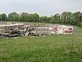
 Assorted farming equipment - geograph.org.uk - 2866829.jpg 640 × 480; 86 KB
-
 Basingstoke and Deane , M3 Motorway - geograph.org.uk - 6115594.jpg 6,000 × 4,000; 7.89 MB
-
 Basingstoke and Deane , M3 Motorway - geograph.org.uk - 6115595.jpg 6,000 × 4,000; 2.97 MB
-
 Basingstoke and Deane , M3 Motorway - geograph.org.uk - 6115596.jpg 6,000 × 4,000; 2.9 MB
-
 Basingstoke and Deane , M3 Motorway - geograph.org.uk - 6115597.jpg 6,000 × 4,000; 7.87 MB
-
 Basingstoke and Deane , M3 Motorway - geograph.org.uk - 6115598.jpg 6,000 × 4,000; 2.72 MB
-
 Basingstoke and Deane , M3 Motorway - geograph.org.uk - 6115599.jpg 6,000 × 4,000; 7.7 MB
-
 Basingstoke and Deane , M3 Motorway - geograph.org.uk - 6115600.jpg 6,000 × 4,000; 3.02 MB
-
 Basingstoke and Deane , M3 Motorway - geograph.org.uk - 6115601.jpg 6,000 × 4,000; 7.72 MB
-
 Basingstoke and Deane , M3 Motorway - geograph.org.uk - 6115602.jpg 6,000 × 4,000; 2.84 MB
-
 Basingstoke and Deane , M3 Motorway - geograph.org.uk - 6115603.jpg 6,000 × 4,000; 7.61 MB
-
 Basingstoke Golf Club - geograph.org.uk - 2366226.jpg 640 × 477; 99 KB
-
 Basingstoke Golf Club - geograph.org.uk - 5499991.jpg 640 × 480; 141 KB
-
 Basingstoke Golf Club - geograph.org.uk - 5499992.jpg 640 × 480; 138 KB
-
 Basingstoke Golf Club - geograph.org.uk - 5499995.jpg 640 × 456; 74 KB
-
 Basingstoke Golf Club - geograph.org.uk - 5500004.jpg 640 × 480; 128 KB
-
 Basingstoke Golf Club - geograph.org.uk - 5500005.jpg 640 × 480; 116 KB
-
 Basingstoke Golf Course - geograph.org.uk - 2764830.jpg 640 × 480; 106 KB
-
 Basingstoke Golf Course - geograph.org.uk - 3377498.jpg 640 × 425; 99 KB
-
 Basingstoke Golf Course - geograph.org.uk - 3657324.jpg 640 × 480; 87 KB
-
 Basingstoke Golf Course - geograph.org.uk - 3657330.jpg 640 × 480; 101 KB
-

-
 Beggarwood Lane - geograph.org.uk - 3377487.jpg 640 × 425; 47 KB
-
 Bits of farming stuff - geograph.org.uk - 3700683.jpg 640 × 476; 117 KB
-
 Bits ^ bobs - geograph.org.uk - 2866827.jpg 640 × 480; 71 KB
-

-
 Bridleway -cycleway - Nutley Lane - geograph.org.uk - 2852125.jpg 640 × 425; 122 KB
-
 Bridleway -cycleway - Nutley Lane - geograph.org.uk - 2852133.jpg 640 × 425; 100 KB
-
 Bridleway approaching Southwood Farm - geograph.org.uk - 5332815.jpg 640 × 480; 97 KB
-
 Bridleway by Dummer Down Farm - geograph.org.uk - 6788025.jpg 1,024 × 768; 384 KB
-
 Bridleway by Dummer Down Farm - geograph.org.uk - 6788030.jpg 1,024 × 768; 353 KB
-
 Bridleway close to Dummer Down House - geograph.org.uk - 6660362.jpg 640 × 480; 138 KB
-
 Bridleway junction near M3 - geograph.org.uk - 381544.jpg 640 × 477; 110 KB
-
 Bridleway near Popham Down Copse - geograph.org.uk - 5360876.jpg 640 × 480; 162 KB
-
 Bridleway north of Southwood Farm - geograph.org.uk - 3619782.jpg 640 × 490; 93 KB
-

-
 Bridleway to Basingstoke - geograph.org.uk - 2866817.jpg 640 × 480; 74 KB
-
 Bridleway to Dummer - geograph.org.uk - 3931152.jpg 800 × 600; 143 KB
-
 Bridleway to Poham Down Copse - geograph.org.uk - 5360836.jpg 640 × 480; 110 KB
-
 Bridleway to Popham Down Copse - geograph.org.uk - 5360841.jpg 640 × 480; 153 KB
-
 Bridleway to Popham Down Copse - geograph.org.uk - 5360850.jpg 640 × 453; 95 KB
-
 Bridleway to Popham Down Copse - geograph.org.uk - 5360856.jpg 640 × 480; 126 KB
-
 Bridleway ^ farm track - geograph.org.uk - 2866823.jpg 639 × 441; 58 KB
-

-
 Builders access to the A30 - geograph.org.uk - 5332832.jpg 640 × 480; 57 KB
-
 Builders yard in a field - geograph.org.uk - 5493016.jpg 640 × 480; 117 KB
-
 Builders yard in a field - geograph.org.uk - 5493022.jpg 640 × 480; 105 KB
-
 Building site - new houses - geograph.org.uk - 5510429.jpg 640 × 480; 119 KB
-
 Bungalows on Up Street, Dummer - geograph.org.uk - 4630275.jpg 2,560 × 1,920; 2.01 MB
-
 Business units - Southwood Farm - geograph.org.uk - 2636831.jpg 639 × 422; 58 KB
-

-
 Byway towards Basingstoke - geograph.org.uk - 3700684.jpg 640 × 482; 110 KB
-
 Central feature - Saunders Way - geograph.org.uk - 5493145.jpg 640 × 480; 85 KB
-
 Choice of paths by Rowley Copse - geograph.org.uk - 3930452.jpg 800 × 600; 230 KB
-
 Close to Southwood Farm - geograph.org.uk - 2636826.jpg 640 × 480; 55 KB
-
 Clump of trees by bridleway - geograph.org.uk - 5360812.jpg 640 × 480; 196 KB
-
 Coachroad Belt - geograph.org.uk - 4088285.jpg 640 × 424; 72 KB
-
 Coachroad Belt - geograph.org.uk - 4088286.jpg 1,024 × 680; 207 KB
-
 Corner of Dummer Road and the A30 - geograph.org.uk - 2954794.jpg 1,600 × 1,200; 558 KB
-
 Corner of Great Stubbs Copse - geograph.org.uk - 2866810.jpg 640 × 480; 135 KB
-
 Corner of Rowley Copse - geograph.org.uk - 5500023.jpg 640 × 480; 121 KB
-
 Corner of the recreation ground - geograph.org.uk - 829517.jpg 640 × 480; 67 KB
-
 Country lane - direction Dummer - geograph.org.uk - 3442886.jpg 640 × 425; 108 KB
-
 Country lane - direction Dummer village - geograph.org.uk - 2958623.jpg 640 × 480; 108 KB
-
 Course of former Roman Road - geograph.org.uk - 5492991.jpg 640 × 480; 158 KB
-
 Course of former Roman Road - geograph.org.uk - 5492993.jpg 640 × 480; 169 KB
-
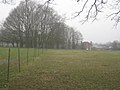
 Cricket field near Dummer - geograph.org.uk - 5500089.jpg 640 × 480; 94 KB
-
 Cricket field near Dummer - geograph.org.uk - 5500091.jpg 640 × 480; 103 KB
-
 Crossing the A30 - geograph.org.uk - 5499980.jpg 640 × 400; 72 KB
-
 Crossing the A30 - geograph.org.uk - 5499987.jpg 640 × 434; 83 KB
-
 Crossing the M3 - geograph.org.uk - 5500006.jpg 640 × 480; 141 KB
-
 Crossing the M3 - geograph.org.uk - 5500007.jpg 640 × 480; 139 KB
-
 Crossing the M3 slip road - geograph.org.uk - 3210209.jpg 640 × 480; 111 KB
-
 Crossroads on the road to Axford - geograph.org.uk - 4628258.jpg 2,560 × 1,920; 2.17 MB
-
 Destroying greenbelt - geograph.org.uk - 5332812.jpg 640 × 419; 64 KB
-
 Did anyone see the sign^ - geograph.org.uk - 3268105.jpg 640 × 480; 115 KB
-
 Distant view of the M3 - geograph.org.uk - 5286955.jpg 1,024 × 768; 222 KB
-
 Distinct line of trees - geograph.org.uk - 2866631.jpg 640 × 480; 131 KB
-
 Disused pit in a field - geograph.org.uk - 5517618.jpg 640 × 480; 112 KB
-
 Dividing paths - geograph.org.uk - 2866625.jpg 640 × 480; 121 KB
-
 Donkeys by bridleway - geograph.org.uk - 3931116.jpg 800 × 600; 203 KB
-
 Double field gates - geograph.org.uk - 3442954.jpg 640 × 425; 135 KB
-
 Down Street - Dummer - geograph.org.uk - 3210212.jpg 640 × 480; 71 KB
-
 Down Street - Dummer - geograph.org.uk - 3808379.jpg 800 × 523; 121 KB
-
 Down Street in Dummer - geograph.org.uk - 3931031.jpg 800 × 600; 114 KB
-
 Down Street, Dummer - geograph.org.uk - 1985674.jpg 640 × 480; 97 KB
-
 Down Street, Dummer - geograph.org.uk - 6818262.jpg 1,920 × 1,280; 1.12 MB
-
 Driveway to Dummer House - geograph.org.uk - 2366162.jpg 640 × 477; 102 KB
-
 Dull hedgerow - geograph.org.uk - 2852156.jpg 640 × 425; 98 KB
-
 Dummer - Down Street - geograph.org.uk - 1216535.jpg 640 × 480; 97 KB
-
 Dummer - Ivy Cottages - geograph.org.uk - 1216129.jpg 640 × 480; 68 KB
-
 Dummer - Path - geograph.org.uk - 1216582.jpg 640 × 480; 82 KB
-
 Dummer - Stores - geograph.org.uk - 1216388.jpg 640 × 480; 58 KB
-
 Dummer - Village Pond - geograph.org.uk - 1216606.jpg 640 × 480; 117 KB
-
 Dummer - Village Seat - geograph.org.uk - 1216457.jpg 640 × 480; 66 KB
-
 Dummer Countryside - geograph.org.uk - 829565.jpg 640 × 480; 68 KB
-
 Dummer Countryside - geograph.org.uk - 829748.jpg 640 × 480; 83 KB
-
 Dummer countryside - geograph.org.uk - 830704.jpg 640 × 480; 67 KB
-
 Dummer Down Farm - geograph.org.uk - 2847587.jpg 640 × 480; 84 KB
-
 Dummer Down Farm - geograph.org.uk - 2847602.jpg 640 × 480; 69 KB
-
 Dummer Down farmland - geograph.org.uk - 2847604.jpg 640 × 480; 72 KB
-
 Dummer Down Lane - geograph.org.uk - 4630273.jpg 2,560 × 1,920; 1.92 MB
-
 Dummer Down Lane at the junction of Dummer Road - geograph.org.uk - 2955000.jpg 1,600 × 1,200; 581 KB
-
 Dummer Down Lane at the junction of Up Street - geograph.org.uk - 4630274.jpg 2,560 × 1,920; 2.1 MB
-
 Dummer Down Road, North Waltham - geograph.org.uk - 4628257.jpg 2,560 × 1,920; 1.89 MB
-
 Dummer Firs - geograph.org.uk - 5499978.jpg 640 × 480; 110 KB
-
 Dummer Golf Club - geograph.org.uk - 3210218.jpg 640 × 480; 59 KB
-
 Dummer Golf Club - geograph.org.uk - 3210219.jpg 640 × 480; 58 KB
-
 Dummer Golf Club - geograph.org.uk - 5500015.jpg 640 × 480; 96 KB
-
 Dummer Grange driveway - geograph.org.uk - 3443547.jpg 640 × 425; 80 KB
-
 Dummer Grange driveway - geograph.org.uk - 3443556.jpg 640 × 425; 75 KB
-
 Dummer Grange Farm - geograph.org.uk - 3443549.jpg 640 × 425; 96 KB
-
 Dummer Grange farmland - geograph.org.uk - 3443572.jpg 640 × 425; 68 KB
-
 Dummer Grange farmland - geograph.org.uk - 3443573.jpg 640 × 425; 75 KB
-
 Dummer House from Wayfarer's Walk - geograph.org.uk - 952007.jpg 640 × 480; 93 KB
-
 Dummer Road at the junction of Dummer Down Lane - geograph.org.uk - 2955205.jpg 1,600 × 1,200; 530 KB
-
 Dummer Road going under the M3 motorway - geograph.org.uk - 2955203.jpg 1,600 × 1,200; 559 KB
-
 Dummer to the A30 - geograph.org.uk - 5517643.jpg 640 × 480; 126 KB
-
 Dummer, All Saints Church - geograph.org.uk - 6262915.jpg 6,734 × 4,489; 5.22 MB
-

-
 Dummer, All Saints Church, Benefaction board - geograph.org.uk - 6262958.jpg 3,725 × 5,586; 5.19 MB
-

-

-
 Dummer, All Saints Church, Elizabeth Forbes memorial plaque - geograph.org.uk - 6262941.jpg 6,309 × 4,207; 6.27 MB
-

-

-

-

-

-
 Dummer, All Saints Church, Seen through the lych gate - geograph.org.uk - 6262970.jpg 6,037 × 4,024; 3.47 MB
-

-
 Dummer, All Saints Church, South western aspect - geograph.org.uk - 6262918.jpg 6,146 × 4,097; 6.41 MB
-
 Dummer, All Saints Church, South western aspect - geograph.org.uk - 6262919.jpg 5,986 × 3,991; 5.97 MB
-
 Dummer, All Saints Church, Southern aspect - geograph.org.uk - 6262922.jpg 6,924 × 4,615; 6.73 MB
-
 Dummer, All Saints Church, Stained glass window - geograph.org.uk - 6262943.jpg 3,746 × 5,619; 2.23 MB
-
 Dummer, All Saints Church, Terry family memorial - geograph.org.uk - 6262956.jpg 4,772 × 7,157; 6.13 MB
-

-
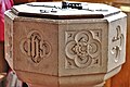 Dummer, All Saints Church, The font bowl - geograph.org.uk - 6262960.jpg 7,091 × 4,727; 6.83 MB
-

-

-
 Dummer, All Saints Church, The pulpit - geograph.org.uk - 6262933.jpg 4,552 × 6,829; 4.54 MB
-
 Dummer, All Saints Church, The pulpit - geograph.org.uk - 6262936.jpg 6,842 × 4,561; 6 MB
-
-

-


_-_geograph.org.uk_-_6262989.jpg)

_-_geograph.org.uk_-_6262949.jpg)


_-_geograph.org.uk_-_6262931.jpg)
