Category:Duke of Cornwall's Light Infantry War Memorial
Jump to navigation
Jump to search
| Object location | | View all coordinates using: OpenStreetMap |
|---|
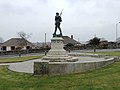
First and Second World War memorial with figure of a First World War infantryman marching with slung rifle .jpg) | |||||
| Upload media | |||||
| Instance of | |||||
|---|---|---|---|---|---|
| Location | Bodmin, Cornwall, South West England, England | ||||
| Heritage designation |
| ||||
 | |||||
This is a category about listed building number 1298217. |
Media in category "Duke of Cornwall's Light Infantry War Memorial"
The following 2 files are in this category, out of 2 total.
-
 Bodmin Military Museum 01.jpg 4,075 × 3,056; 3.01 MB
-