Category:Dubh Loch, Letterewe
Jump to navigation
Jump to search
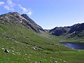
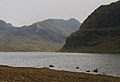
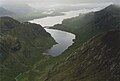
Dubh Loch, Letterewe, lies at the southern end of Fionn Loch.
Media in category "Dubh Loch, Letterewe"
The following 18 files are in this category, out of 18 total.
-
 Causeway - geograph.org.uk - 260977.jpg 640 × 582; 57 KB
-
 Dubh Loch - geograph.org.uk - 26181.jpg 640 × 413; 46 KB
-
 Dubh Loch and A'Mhaighdean - geograph.org.uk - 1290097.jpg 640 × 480; 77 KB
-

-
 Fisherfield - geograph.org.uk - 260968.jpg 640 × 465; 74 KB
-
 Gully, Beinn Lair - geograph.org.uk - 1390214.jpg 480 × 640; 137 KB
-
 Maidens View - geograph.org.uk - 836599.jpg 640 × 480; 42 KB
-
 NE summit slopes of Meall Mheinnidh - geograph.org.uk - 1390133.jpg 640 × 480; 99 KB
-
 The causeway at Carnmore - geograph.org.uk - 750718.jpg 1,000 × 670; 276 KB
-

-
-
 The Dubh Loch - geograph.org.uk - 751879.jpg 1,000 × 684; 210 KB
-
 The Dubh Loch - geograph.org.uk - 751890.jpg 1,000 × 665; 224 KB
-
 The Wee Lochan - geograph.org.uk - 1240386.jpg 640 × 429; 135 KB
-
 View across the Dubh Loch - geograph.org.uk - 504089.jpg 1,000 × 667; 229 KB
-
-
 View SW over Dubh Loch - geograph.org.uk - 262735.jpg 639 × 418; 156 KB
-


