Category:Dorpssingel 2, Beuningen
Jump to navigation
Jump to search
| Object location | | View all coordinates using: OpenStreetMap |
|---|
 | |||||
| Upload media | |||||
| Instance of | |||||
|---|---|---|---|---|---|
| Part of | |||||
| Location | Beuningen, Gelderland, Netherlands | ||||
| Street address |
| ||||
| Architectural style | |||||
| Heritage designation |
| ||||
| Inception |
| ||||
 | |||||
Pastorie
|
This is a category about rijksmonument number 523150
|
Koetshuis
|
This is a category about rijksmonument number 523151
|
Tuinbeeld
|
This is a category about rijksmonument number 523152
|
Tuinmuur
|
This is a category about rijksmonument number 523153
|
| Address |
|
Subcategories
This category has only the following subcategory.
H
- Heilig Hartbeeld (Beuningen) (8 F)
Media in category "Dorpssingel 2, Beuningen"
The following 8 files are in this category, out of 8 total.
-
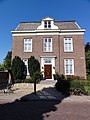 Beuningen Rijksmonument 523150 pastorie Dorpssingel 2.jpg 2,736 × 3,648; 3.46 MB
-
 Beuningen Rijksmonument 523151 koetshuis (gerestaureerd 2011) Dorpsingel 2.JPG 3,648 × 2,736; 4.12 MB
-
 Beuningen Rijksmonument 523151 koetshuis (in restauratie) Dorpsingel 2.JPG 3,648 × 2,736; 4.25 MB
-
 Beuningen Rijksmonument 523151 koetshuis (in vernieuwbouw) Dorpsingel 2.JPG 3,648 × 2,736; 4.26 MB
-
 Beuningen Rijksmonument 523151 koetshuis (plaquette restauratie) Dorpsingel 2.JPG 3,648 × 2,736; 4.32 MB
-
 Beuningen Rijksmonument 523153 tuinmuur en tuinhek Dorpsingel 2.JPG 3,648 × 2,736; 4.13 MB
-
 Voor- en rechter zijgevel - Beuningen - 20034306 - RCE.jpg 1,200 × 951; 243 KB
-
 Voorgevel - Beuningen - 20034307 - RCE.jpg 1,200 × 950; 255 KB
_Dorpsingel_2.JPG)
_Dorpsingel_2.JPG)
_Dorpsingel_2.JPG)
_Dorpsingel_2.JPG)


