Category:Dorotea Municipality
Jump to navigation
Jump to search
municipality in Västerbotten County, Sweden  Kommunhuset   | |||||
| Upload media | |||||
| Pronunciation audio | |||||
|---|---|---|---|---|---|
| Instance of | |||||
| Part of | |||||
| Location | Västerbotten County, Sweden | ||||
| Capital | |||||
| Official language | |||||
| Legal form | |||||
| Inception |
| ||||
| Population |
| ||||
| Area |
| ||||
| Different from | |||||
| official website | |||||
 | |||||
Subcategories
This category has the following 7 subcategories, out of 7 total.
Media in category "Dorotea Municipality"
The following 13 files are in this category, out of 13 total.
-
 Avasjö kapell Borgafjäll.JPG 3,872 × 2,592; 4.24 MB
-
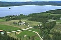
 Avatrask Sweden 2012.jpg 3,000 × 1,965; 2.43 MB
-
 Borgahällan.jpg 4,032 × 3,024; 3.65 MB
-
 Dorotea in Sweden.png 372 × 840; 21 KB
-
 Dorotea kommunvapen - Riksarkivet Sverige-vector.svg 512 × 591; 833 KB
-
 Dorotea kommunvapen - Riksarkivet Sverige.png 1,429 × 1,666; 111 KB
-
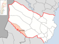 Dorotea Municipality in Västerbotten County.png 691 × 514; 91 KB
-
 Dorotea vapen.svg 251 × 304; 128 KB
-
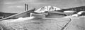 Hotell Borgafjäll.jpg 2,286 × 810; 462 KB
-
 Laiksjö by - KMB - 16000300022465.jpg 743 × 483; 68 KB
-
 Laiksjö by - KMB - 16000300022466.jpg 740 × 478; 66 KB
-
 Regnbågshylla på Dorotea bibliotek.jpg 2,829 × 3,842; 1.8 MB
-
 Stationshuset i Dorotea.jpg 4,000 × 2,547; 4.52 MB


