Category:Dorfstrasse 1 (Meienried)
Jump to navigation
Jump to search
| Object location | | View all coordinates using: OpenStreetMap |
|---|
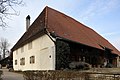
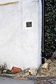
farmhouse and inn in Meienried in the canton of Bern, Switzerland  | |||||
| Upload media | |||||
| Instance of |
| ||||
|---|---|---|---|---|---|
| Part of | |||||
| Location | Meienried, Seeland administrative district, Seeland administrative region, Bern, Switzerland | ||||
| Street address |
| ||||
| Heritage designation |
| ||||
| Inception |
| ||||
 | |||||
Media in category "Dorfstrasse 1 (Meienried)"
The following 7 files are in this category, out of 7 total.
-
 Schneider Geburtshaus Meienried 01 11.jpg 1,575 × 1,049; 835 KB
-
 Schneider Geburtshaus Meienried 02 11.jpg 1,049 × 1,575; 765 KB
-
 Schneider Geburtshaus Meienried 03 11.jpg 1,575 × 1,049; 729 KB
-
 Schneider Geburtshaus Meienried 04 11.jpg 1,575 × 1,049; 942 KB
-
 Schneider Geburtshaus Meienried 05 11.jpg 1,575 × 1,049; 906 KB
-
 Schneider Geburtshaus Meienried 06 11.jpg 1,575 × 1,049; 1.06 MB
-
 Schneider Geburtshaus Meienried 07 11.jpg 1,575 × 1,049; 770 KB


