Category:Dorfstraße 56 (Schönau)
Jump to navigation
Jump to search
| Object location | | View all coordinates using: OpenStreetMap |
|---|
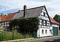
| This category shows a heritage building in Germany, located in the North Rhine-Westphalian city Bad Münstereifel (no. 258). |
Media in category "Dorfstraße 56 (Schönau)"
The following 4 files are in this category, out of 4 total.
-
 Schönau Dorfstraße 56 (01).jpg 5,172 × 3,600; 4.44 MB
-
 Schönau Dorfstraße 56 (02).jpg 5,082 × 3,690; 4.59 MB
-
 Schönau Dorfstraße 56 (03).jpg 3,224 × 4,992; 3.91 MB
-
 Schönau Dorfstraße 56 (04).jpg 5,172 × 2,058; 2.65 MB
.jpg)
.jpg)
.jpg)
.jpg)