Category:Dorfmuseum, Kölliken
Jump to navigation
Jump to search
| Object location | | View all coordinates using: OpenStreetMap |
|---|
building in Kölliken in the canton of Aargau, Switzerland  | |||||
| Upload media | |||||
| Instance of | |||||
|---|---|---|---|---|---|
| Part of | |||||
| Location | Kölliken, Zofingen District, Aargau, Switzerland | ||||
| Street address |
| ||||
| Occupant | |||||
| Heritage designation | |||||
| Inception |
| ||||
 | |||||
Media in category "Dorfmuseum, Kölliken"
The following 8 files are in this category, out of 8 total.
-
 Dorfmuseum Kölliken getting renovated.jpg 5,760 × 3,840; 9.51 MB
-
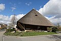
 Kölliken Dorfmuseum 001.jpg 3,888 × 2,592; 3.68 MB
-
 Kölliken Dorfmuseum 003.jpg 3,888 × 2,592; 3.55 MB
-
 Kölliken Dorfmuseum 004.jpg 3,539 × 2,221; 2.93 MB
-
 Kölliken Dorfmuseum Strohhaus Zoom.JPG 2,592 × 1,944; 1.64 MB
-
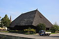
 Kölliken Dorfmuseum Strohhaus.JPG 2,592 × 1,944; 1.12 MB
-
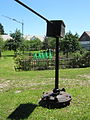 Pferdegöpel, Kölliken Dorfmuseum Strohhaus.JPG 1,944 × 2,592; 1.71 MB
-
 Salzmehuus Kölliken.jpg 2,048 × 1,536; 1.3 MB


