Category:Dorfkirche Vieritz
Jump to navigation
Jump to search
| Object location | | View all coordinates using: OpenStreetMap |
|---|
church building in Brandenburg state, Germany  | |||||
| Upload media | |||||
| Instance of | |||||
|---|---|---|---|---|---|
| Location | Vieritz, Milower Land, Havelland District, Brandenburg, Germany | ||||
| Heritage designation | |||||
 | |||||
This is the category of the Brandenburger Baudenkmal (cultural heritage monument) with the ID 09150376 (Wikidata)
|
English: Church in Vieritz, Milower Land municipality, Havelland district, Brandenburg state, Germany.
Deutsch: Dorfkirche in Vieritz, Gemeinde Milower Land, Landkreis Havelland, Land Brandenburg, Deutschland.
Français : Église de Vieritz, commune de Milower Land, arrondissement Pays de la Havel, état fédéral de Brandebourg, Allemagne
Subcategories
This category has only the following subcategory.
B
- Bells of Dorfkirche Vieritz (3 F)
Media in category "Dorfkirche Vieritz"
The following 7 files are in this category, out of 7 total.
-
 Dorfkirche Vieritz 2017 NE.jpg 4,850 × 4,097; 9.23 MB
-
 Dorfkirche Vieritz 2017 Portal W.jpg 3,538 × 4,782; 7.94 MB
-
 Dorfkirche Vieritz 2017 S.jpg 4,864 × 3,648; 7.73 MB
-
 Dorfkirche Vieritz 2017 SE.jpg 3,648 × 4,864; 6.17 MB
-
 Gefallenendenkmal Vieritz 2017 SE.jpg 3,648 × 4,864; 8.14 MB
-
 Kirche Vieritz 2011 01.jpg 2,848 × 2,136; 3.57 MB
-
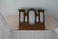 Orgel Dorfkirche Vieritz.jpg 4,592 × 3,064; 5.69 MB


