Category:Dorfkirche Tauer
Jump to navigation
Jump to search

| Object location | | View all coordinates using: OpenStreetMap |
|---|
church building in Brandenburg state, Germany  | |||||
| Upload media | |||||
| Instance of | |||||
|---|---|---|---|---|---|
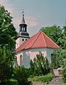
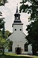
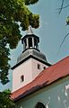
| Location | Tauer, Spree-Neiße District, Brandenburg, Germany | ||||
| Street address |
| ||||
| Heritage designation | |||||
| Inception |
| ||||
 | |||||
This is the category of the Brandenburger Baudenkmal (cultural heritage monument) with the ID 09125341 (Wikidata)
|
English: Pictures of the church in Tauer, Tauer municipality, Spree-Neiße district, Brandenburg state, Germany.
Deutsch: Ansichten der Kirche in Tauer, Gemeinde Tauer, Landkreis Spree-Neiße, Land Brandenburg, Deutschland.
Français : Photos de l'église à Tauer, commune de Tauer, arrondissement de Spree-Neiße, état fédéral de Brandebourg, Allemagne
Español: Vistas de la iglesia en Tauer, municipio de Tauer, distrito de Spree-Neiße, estado federado de Brandeburgo, Alemania
Address: Alte Schulstraße 18, 03185 Tauer
Subcategories
This category has the following 2 subcategories, out of 2 total.
F
- Friedhof Tauer (7 F)
I
- Interior of Dorfkirche Tauer (1 F)
Media in category "Dorfkirche Tauer"
The following 8 files are in this category, out of 8 total.
-
 Tauer Dorfkirche 1.jpg 976 × 1,264; 1.26 MB
-
 Tauer Dorfkirche 2.jpg 992 × 1,488; 1.37 MB
-
 Tauer Dorfkirche 3.jpg 960 × 1,472; 668 KB
-
 Tauer Dorfkirche 4.jpg 976 × 1,520; 1.39 MB
-
 Tauer Dorfkirche 5.jpg 1,008 × 1,456; 1.19 MB
-
 Tauer Dorfkirche Kirchhof.jpg 1,024 × 1,504; 1.83 MB
-
 Tauer Dorfkirche Kriegerdenkmal 1.jpg 1,504 × 1,024; 1.65 MB
-
 Tauer, die Dorfkirche.jpg 2,551 × 1,701; 1.36 MB


