Category:Dorfkirche Stöbritz
Jump to navigation
Jump to search
| Object location | | View all coordinates using: OpenStreetMap |
|---|
church building in Luckau, Dahme-Spreewald district, Brandenburg state, Germany  | |||||
| Upload media | |||||
| Instance of | |||||
|---|---|---|---|---|---|
| Location | Willmersdorf-Stöbritz, Luckau, Dahme-Spreewald District, Brandenburg, Germany | ||||
| Street address |
| ||||
| Architectural style |
| ||||
| Heritage designation | |||||
| Inception |
| ||||
| Religion or worldview | |||||
 | |||||
This is the category of the Brandenburger Baudenkmal (cultural heritage monument) with the ID 09140458 (Wikidata)
|
English: Pictures of the village church in Stöbritz, Luckau municipality, Dahme-Spreewald district, Brandenburg state, Germany.
Deutsch: Ansichten der Dorfkirche in Stöbritz, Stadt Luckau , Landkreis Dahme-Spreewald , Land Brandenburg , Deutschland.
Français : Photos de l'église du village à Stöbritz, ville de Luckau, , arrondissement de Dahme-Spreewald , état federé de Brandebourg , Allemagne.
Español: Vistas de la iglesia del pueblo en Stöbritz, ciudad de Luckau, distrito de Dahme-Spreewald , estado federado de Brandeburgo , Alemania.
Address: Stöbritz 17, 15926 Willmersdorf-Stöbritz
Pages in category "Dorfkirche Stöbritz"
This category contains only the following page.
Media in category "Dorfkirche Stöbritz"
The following 24 files are in this category, out of 24 total.
-
 Dorfkirche Stöbritz 2024 E.jpg 3,024 × 3,976; 2.87 MB
-
 Dorfkirche Stöbritz 2024 Fenster.jpg 2,415 × 3,623; 2.17 MB
-
 Dorfkirche Stöbritz 2024 NE.jpg 4,032 × 3,024; 4.23 MB
-
 Dorfkirche Stöbritz 2024 Nordportal.jpg 2,829 × 3,895; 3.89 MB
-
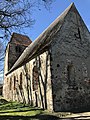
 Dorfkirche Stöbritz 2024 S.jpg 3,648 × 2,736; 3.25 MB
-
 Dorfkirche Stöbritz 2024 Sakristei.jpg 3,024 × 3,669; 3.35 MB
-
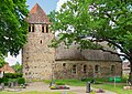
 Dorfkirche Stöbritz 2024 SSW.jpg 4,032 × 3,024; 5.9 MB
-
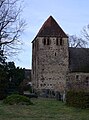 Dorfkirche Stöbritz 2024 Turm.jpg 2,666 × 3,597; 2.06 MB
-
 Dorfkirche Willmersdorf-Stöbritz Chornordanbau Nordpforte.jpg 4,032 × 3,024; 4.77 MB
-
 Dorfkirche Willmersdorf-Stöbritz Chornordanbau.jpg 3,024 × 4,032; 3.37 MB
-
 Dorfkirche Willmersdorf-Stöbritz Grabmal westlich des Turms.jpg 3,024 × 4,032; 4.46 MB
-
 Dorfkirche Willmersdorf-Stöbritz Kirchenschiff Nordpforte.jpg 4,032 × 3,024; 2.03 MB
-
 Dorfkirche Willmersdorf-Stöbritz Kirchenschiff Südansicht.jpg 4,032 × 3,024; 4.58 MB
-
 Dorfkirche Willmersdorf-Stöbritz Nordansicht.jpg 4,032 × 3,024; 3.63 MB
-
 Dorfkirche Willmersdorf-Stöbritz Ostansicht.jpg 3,024 × 4,032; 3.72 MB
-
 Dorfkirche Willmersdorf-Stöbritz Südansicht.jpg 4,032 × 3,024; 5.51 MB
-
 Dorfkirche Willmersdorf-Stöbritz Südostansicht.jpg 3,024 × 4,032; 4.55 MB
-
 Dorfkirche Willmersdorf-Stöbritz Westturm Südansicht.jpg 3,024 × 4,032; 5.09 MB
-
 Dorfkirche Willmersdorf-Stöbritz Westturm Westansicht.jpg 3,024 × 4,032; 5.59 MB
-
 Willmersdorf Stoebritz Dorfkirche 05.jpg 5,103 × 3,617; 17.73 MB
-
 Willmersdorf Stoebritz Dorfkirche 05.tif 5,103 × 3,617; 105.65 MB
-
 Willmersdorf Stoebritz Dorfkirche 06.jpg 4,909 × 3,627; 16.74 MB
-
 Willmersdorf Stoebritz Dorfkirche 06.tif 4,909 × 3,627; 101.92 MB
-
 Willmersdorf Stoebritz Dorfkirche 07.jpg 4,714 × 3,320; 11.36 MB


