Category:Dorfkirche Schmachtenhagen
Jump to navigation
Jump to search
| Object location | | View all coordinates using: OpenStreetMap |
|---|
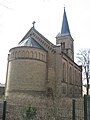
church building in Oberhavel district, Brandenburg state, Germany  | |||||
| Upload media | |||||
| Instance of | |||||
|---|---|---|---|---|---|
| Location | Schmachtenhagen, Oranienburg, Oberhavel District, Brandenburg, Germany | ||||
| Street address |
| ||||
| Heritage designation | |||||
 | |||||
This is the category of the Brandenburger Baudenkmal (cultural heritage monument) with the ID 09165309 (Wikidata)
|
English: Church in Schmachtenhagen, Oranienburg municipality, Oberhavel district, Brandenburg state, Germany
Deutsch: Dorfkirche in Schmachtenhagen, Stadt Oranienburg, Landkreis Oberhavel, Land Brandenburg, Deutschland
Français : Église de Schmachtenhagen, ville de Oranienburg, arrondissement de Haute-Havel, état fédéral de Brandebourg, Allemagne
Pages in category "Dorfkirche Schmachtenhagen"
This category contains only the following page.
Media in category "Dorfkirche Schmachtenhagen"
The following 8 files are in this category, out of 8 total.
-
 Dorfkirche Schmachtenhagen 2016 NE.jpg 3,085 × 3,782; 5.24 MB
-
 Dorfkirche Schmachtenhagen 2016 SE.jpg 3,099 × 3,322; 4.33 MB
-
 Dorfkirche Schmachtenhagen 2016 SW.jpg 2,903 × 3,763; 5 MB
-
 Dorfkirche Schmachtenhagen 2020 Westportal.jpg 3,648 × 4,864; 6.74 MB
-
 Oranienburg - Schmachtenhagen - Evangelische Kirche - 2013.jpg 1,365 × 2,048; 2.3 MB
-
 Schmachtenhagen Kirche 2.jpg 3,072 × 2,304; 3.26 MB
-
 Schmachtenhagen Kirche 3.jpg 2,304 × 3,072; 3.08 MB
-
 Schmachtenhagen Kirche.jpg 2,304 × 3,072; 3.44 MB


