Category:Dorfkirche Schmöckwitz
Jump to navigation
Jump to search
| Object location | | View all coordinates using: OpenStreetMap |
|---|
church building in Berlin  .jpg)  | |||||
| Upload media | |||||
| Instance of | |||||
|---|---|---|---|---|---|
| Location | Schmöckwitz, Treptow-Köpenick, Berlin, Germany | ||||
| Street address |
| ||||
| Architectural style | |||||
| Architect |
| ||||
| Has use | |||||
| Heritage designation | |||||
| Date of official opening |
| ||||
 | |||||
This is the category of the Berliner Kulturdenkmal (cultural monument) with the ID 09045548 (Wikidata)
|
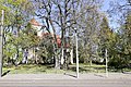
Deutsch: Die Dorfkirche Schmöckwitz in Berlin-Schmöckwitz dient einer Gemeinde der unierten Evangelischen Kirche Berlin-Brandenburg-Schlesische Oberlausitz.
English: The village church of Schmöckwitz, Berlin, Germany, serves a congregation within the Evangelical Church of Berlin-Brandenburg-Silesian Upper Lusatia, a united Protestant church body of Calvinist, Lutheran and united congregations.
Subcategories
This category has the following 2 subcategories, out of 2 total.
I
K
Media in category "Dorfkirche Schmöckwitz"
The following 24 files are in this category, out of 24 total.
-
 Alt-Schmöckwitz-7178.jpg 5,472 × 3,648; 19.75 MB
-
 Alt-Schmöckwitz-7179.jpg 5,472 × 3,648; 7.13 MB
-
 Alt-Schmöckwitz-7180.jpg 3,648 × 5,472; 17.28 MB
-
 Alt-Schmöckwitz-7181.jpg 5,472 × 3,648; 20.86 MB
-
 Alt-Schmöckwitz-7182.jpg 5,472 × 3,648; 22.26 MB
-
 Alt-Schmöckwitz-7183.jpg 5,472 × 3,648; 20.16 MB
-
 Alt-Schmöckwitz-7184.jpg 5,366 × 3,499; 17.06 MB
-
 Alt-Schmöckwitz-7186.jpg 5,410 × 3,607; 11.27 MB
-
 Alt-Schmöckwitz-7187.jpg 2,924 × 2,054; 4.06 MB
-
 Alt-Schmöckwitz-7188.jpg 3,236 × 4,602; 5.71 MB
-
 Alt-Schmöckwitz-7189.jpg 3,459 × 4,448; 5.78 MB
-
 Alt-Schmöckwitz-7190.jpg 3,949 × 2,927; 4.81 MB
-
 Berlin Schmoeckwitz Dorfkirche 20140627.JPG 4,004 × 3,177; 5.29 MB
-
 Berlin Schmöckwitz lub 2023-04-22 Kirche img01.jpg 4,032 × 3,024; 9.16 MB
-
 Berlin Schmöckwitz lub 2023-04-22 Kirche img02.jpg 4,032 × 3,024; 7.68 MB
-
 Berlin Schmöckwitz lub 2023-04-22 Kirche img03.jpg 3,024 × 4,032; 4.57 MB
-
 Dorfkirche Schmöckwitz 02 (cropped).jpg 533 × 699; 270 KB
-
 Dorfkirche Schmöckwitz 02.jpg 533 × 800; 299 KB
-
 Dorfkirche Schmöckwitz quer.jpg 3,872 × 2,592; 6.56 MB
-
 Dorfkirche Schmöckwitz.JPG 1,880 × 2,816; 3.66 MB
-
 Evangelische Dorfkirche Schmöckwitz, Berlin, Treptow-Köpenick.jpg 1,768 × 2,476; 1.14 MB
-
 Gedenktafel Alt-Schmöckwitz (Schmö) staatliche Willkür.jpg 1,609 × 2,242; 1.55 MB
-
 Schmöckwitz church Ev Kirchengemeinde 2.jpg 1,600 × 1,200; 810 KB
-
 Schmöckwitz church Ev Kirchengemeinde.jpg 3,264 × 2,448; 2.43 MB


.jpg)


_staatliche_Willk%C3%BCr.jpg)

