Category:Dorfkirche Rutenberg
Jump to navigation
Jump to search
| Object location | | View all coordinates using: OpenStreetMap |
|---|
 | |||||
| Upload media | |||||
| Instance of | |||||
|---|---|---|---|---|---|
| Location | Q117382146, Lychen, Uckermark District, Brandenburg, Germany | ||||
| Heritage designation | |||||
 | |||||
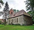
This is the category of the Brandenburger Baudenkmal (cultural heritage monument) with the ID 09130605 (Wikidata)
|
Français : Église de Rutenberg, ville de Lychen, arrondissement Uckermark, état fédéral de Brandebourg, Allemagne
Media in category "Dorfkirche Rutenberg"
The following 7 files are in this category, out of 7 total.
-
 Rutenberg church 2016 E.jpg 5,767 × 4,589; 10.24 MB
-
 Rutenberg church 2016 NE.jpg 5,603 × 4,523; 10.32 MB
-
 Rutenberg church 2016 portal S.jpg 3,648 × 4,864; 7.06 MB
-
 Rutenberg church 2016 portal W.jpg 3,648 × 4,864; 7.82 MB
-
 Rutenberg church 2016 SE.jpg 4,802 × 4,214; 9.66 MB
-
 Rutenberg church 2016 SW.jpg 3,945 × 4,361; 7.6 MB
-
 Rutenberg church 2016 wall N.jpg 3,648 × 4,864; 6.74 MB


