Category:Dorfkirche Rieben
Jump to navigation
Jump to search
| Object location | | View all coordinates using: OpenStreetMap |
|---|
church building in Brandenburg state, Germany  | |||||
| Upload media | |||||
| Instance of | |||||
|---|---|---|---|---|---|
| Location | Rieben, Beelitz, Potsdam-Mittelmark District, Brandenburg, Germany | ||||
| Heritage designation | |||||
 | |||||
This is the category of the Brandenburger Baudenkmal (cultural heritage monument) with the ID 09190764 (Wikidata)
|
Media in category "Dorfkirche Rieben"
The following 17 files are in this category, out of 17 total.
-
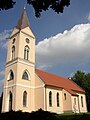 Beelitz Rieben church.jpg 1,488 × 1,984; 272 KB
-
Beelitz-Rieben Dorfkirche Südansicht Video.webm 21 s, 1,920 × 1,080; 8.11 MB
-
 Dorfkirche Rieben - Germany - panoramio.jpg 2,592 × 1,944; 1.6 MB
-
 Dorfkirche Rieben - panoramio.jpg 1,944 × 2,592; 1.34 MB
-
 Dorfkirche Rieben Altarraum.JPG 2,580 × 1,928; 1.85 MB
-
 Dorfkirche Rieben Anbau.JPG 2,592 × 1,944; 1.53 MB
-
 Dorfkirche Rieben Chor.JPG 2,592 × 1,944; 2.26 MB
-
 Dorfkirche Rieben Fünte.JPG 1,944 × 2,592; 1.63 MB
-
 Dorfkirche Rieben Gemeinderaum Nordseite.JPG 2,592 × 1,944; 1.32 MB
-
 Dorfkirche Rieben Gemeinderaum Südseite.JPG 2,592 × 1,944; 1.4 MB
-
 Dorfkirche Rieben Kanzel.JPG 1,944 × 2,592; 1.02 MB
-
 Dorfkirche Rieben Nordportal.JPG 1,944 × 2,592; 1.4 MB
-
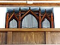 Dorfkirche Rieben Orgel und Empore.JPG 2,588 × 1,938; 2.18 MB
-
 Dorfkirche Rieben Südostansicht.JPG 2,592 × 1,944; 1.26 MB
-
 Dorfkirche Rieben Westportal.JPG 2,592 × 1,944; 1.26 MB
-
 Dorfkirche Rieben Westturm und Kirchenschiff Südwestansicht.JPG 1,944 × 2,592; 1.24 MB
-
 Dorfkirche Rieben Westturm.JPG 1,944 × 2,592; 1.21 MB


