Category:Dorfkirche Rambow (Plattenburg)
Jump to navigation
Jump to search
| Object location | | View all coordinates using: OpenStreetMap |
|---|
 | |||||
| Upload media | |||||
| Instance of | |||||
|---|---|---|---|---|---|
| Location | Q117323905, Plattenburg, Prignitz District, Brandenburg, Germany | ||||
| Heritage designation | |||||
 | |||||
This is the category of the Brandenburger Baudenkmal (cultural heritage monument) with the ID 09160603 (Wikidata)
|
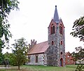
Deutsch: Die Dorfkirche in Rambow, Gemeinde Plattenburg, Landkreis Prignitz, Land Brandenburg, ist ein Feldsteinbau aus der Zeit um 1500. Das Dach ziert ein schöner Staffelgiebel. 1874 wurde ein Feldsteinturm angebaut und die Inneneinrichtung erneuert inclusive einer Hollenbach-Orgel. Kirche und Turm wurden 2000 bis 2002 grundlegend saniert.
Français : Église de Rambow, commune de Plattenburg, arrondissement Prignitz, état fédéral de Brandebourg, Allemagne
Media in category "Dorfkirche Rambow (Plattenburg)"
The following 4 files are in this category, out of 4 total.
-
 Rambow Kirche 1.JPG 3,000 × 4,000; 2.39 MB
-
 Rambow Kirche 2.JPG 3,000 × 4,000; 2.46 MB
-
 Rambow Kirche 3.JPG 3,500 × 2,965; 2.84 MB
-
 Rambow Kirche 4.JPG 3,000 × 4,000; 2.85 MB


