Category:Dorfkirche Neuküstrinchen
Jump to navigation
Jump to search
| Object location | | View all coordinates using: OpenStreetMap |
|---|
  | |||||
| Upload media | |||||
| Instance of | |||||
|---|---|---|---|---|---|
| Location | Neuküstrinchen, Oderaue, Märkisch-Oderland District, Brandenburg, Germany | ||||
| Heritage designation | |||||
 | |||||
This is the category of the Brandenburger Baudenkmal (cultural heritage monument) with the ID 09180584 (Wikidata)
|
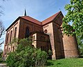
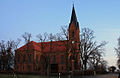
Deutsch: Die evangelische Dorfkirche in Neuküstrinchen (zu Oderaue) gehört und dient einer evangelisch-unierten Kirchengemeinde in der Evangelischen Kirche Berlin-Brandenburg-schlesische Oberlausitz. Sie wurde 1878–1880 erbaut und war vor der Union der Kirchengemeinden eine Simultankirche der lutherischen und der reformierten Gemeinde.
English: The Protestant Village Church in Neuküstrinchen (a locality of Oderaue) is owned and used by a United Protestant congregation within the Evangelical Church of Berlin-Brandenburg-Silesian Upper Lusatia. It was built between 1878–1880, replacing an older precurusor. Before the union of the congregations the church was a simultaneum of the local Lutheran and the local Reformed congregations.
Subcategories
This category has only the following subcategory.
Media in category "Dorfkirche Neuküstrinchen"
The following 8 files are in this category, out of 8 total.
-
 Dorfkirche Neuküstrinchen 2018 S.jpg 4,864 × 3,648; 6.94 MB
-
 Dorfkirche Neuküstrinchen 2018 SE.jpg 5,847 × 4,717; 13.92 MB
-
 Dorfkirche Neuküstrinchen 2018 SW.jpg 4,515 × 4,829; 11.46 MB
-
 Dorfkirche Neuküstrinchen 2018 Turmhaube.jpg 3,648 × 4,864; 5.43 MB
-
 Dorfkirche Neuküstrinchen 2018 Westportal.jpg 3,648 × 4,864; 7.36 MB
-
 IMG 8379NeuküstrinchenDorfkirche.jpg 600 × 389; 82 KB
-
 IMG 8381NeuküstrinchenDorfkirche.jpg 600 × 900; 230 KB
-
 Neuküstrinchen 2018 Gedenkstein für unbekannte Soldaten.jpg 3,648 × 4,864; 8.4 MB


