Category:Dorfkirche Naundorf (Forst (Lausitz))
Jump to navigation
Jump to search
| Object location | | View all coordinates using: OpenStreetMap |
|---|
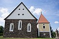
church building in Brandenburg state, Germany  | |||||
| Upload media | |||||
| Instance of | |||||
|---|---|---|---|---|---|
| Location | Naundorf, Forst (Lausitz), Spree-Neiße District, Brandenburg, Germany | ||||
| Heritage designation | |||||
 | |||||
This is the category of the Brandenburger Baudenkmal (cultural heritage monument) with the ID 09125118 (Wikidata)
|
Media in category "Dorfkirche Naundorf (Forst (Lausitz))"
The following 4 files are in this category, out of 4 total.
-
 Dorfkirche Naundorf 01.jpg 6,016 × 4,000; 13.71 MB
-
 Dorfkirche Naundorf 02.jpg 6,016 × 4,000; 14.84 MB
-
 Dorfkirche Naundorf 03.jpg 6,016 × 4,000; 14.6 MB
-
 Dorfkirche Naundorf 04.jpg 6,016 × 4,000; 11.1 MB


