Category:Dorfkirche Nassenheide
Jump to navigation
Jump to search
| Object location | | View all coordinates using: OpenStreetMap |
|---|
church building in Brandenburg state, Germany  | |||||
| Upload media | |||||
| Instance of | |||||
|---|---|---|---|---|---|
| Location | Nassenheide, Löwenberger Land, Oberhavel District, Brandenburg, Germany | ||||
| Heritage designation | |||||
 | |||||
This is the category of the Brandenburger Baudenkmal (cultural heritage monument) with the ID 09165070 (Wikidata)
|
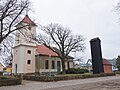
Deutsch: Ansichten der Kirche in Nassenheide, Gemeinde Löwenberger Land, Landkreis Oberhavel, Land Brandenburg, Deutschland. Sie gehört und dient einer lutherischen Gemeinde der unierten Evangelischen Kirche Berlin-Brandenburg-Schlesische Oberlausitz.
English: Pictures of the church in Nassenheide, Löwenberger Land municipality, Oberhavel district, Brandenburg state, Germany. It is owned and used by a Lutheran congregation within the Evangelical Church of Berlin-Brandenburg-Silesian Upper Lusatia, a united Protestant church body of Calvinist, Lutheran and united congregations.
Français : Photos de l'église à Nassenheide, commune de Löwenberger Land, arrondissement de Oberhavel, état fédéral de Brandebourg, Allemagne
Pages in category "Dorfkirche Nassenheide"
This category contains only the following page.
Media in category "Dorfkirche Nassenheide"
The following 9 files are in this category, out of 9 total.
-
 Dorfkirche Nassenheide 2018 INfotafel.jpg 4,864 × 3,648; 3.79 MB
-
 Dorfkirche Nassenheide 2018 NE.jpg 4,864 × 3,648; 6.98 MB
-
 Dorfkirche Nassenheide 2018 SW.jpg 4,118 × 3,493; 6.04 MB
-
 Dorfkirche Nassenheide 2018 Westportal.jpg 3,648 × 4,864; 5.72 MB
-
 Dorfkirche Nassenheide 2018 WNW.jpg 3,013 × 4,256; 6.86 MB
-
 Dorfkirche Nassenheide 2018 WSW.jpg 3,648 × 4,864; 6.7 MB
-
 Dorfkirche und Spritzenhaus Nassenheide 2018 SE.jpg 4,864 × 3,648; 6.09 MB
-
 Dorfkirche und Spritzenhaus Nassenheide 2018 SW.jpg 4,864 × 3,648; 7.07 MB
-
 Nassenheide church.jpg 2,000 × 2,080; 446 KB


