Category:Dorfkirche Mögelin
Jump to navigation
Jump to search
| Object location | | View all coordinates using: OpenStreetMap |
|---|
This is the category of the Brandenburger Baudenkmal (cultural heritage monument) with the ID 09150158 (Wikidata)
|
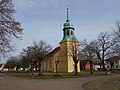
church building in Premnitz, Brandenburg state, Germany  | |||||
| Upload media | |||||
| Instance of | |||||
|---|---|---|---|---|---|
| Location | Mögelin, Premnitz, Havelland District, Brandenburg, Germany | ||||
| Heritage designation | |||||
 | |||||
English: Village church in Mögelin, Premnitz municipality, Havelland district, Brandenburg state, Germany
Français : Église de Mögelin, ville de Premnitz, arrondissement Pays de la Havel, état fédéral de Brandebourg, Allemagne
Media in category "Dorfkirche Mögelin"
The following 13 files are in this category, out of 13 total.
-
 Dorfkirche Mögelin 2017 E.jpg 3,648 × 4,864; 7.34 MB
-
 Dorfkirche Mögelin 2017 NNW.jpg 4,419 × 4,542; 7.5 MB
-
 Dorfkirche Mögelin 2017 NW.jpg 4,864 × 3,648; 5.84 MB
-
 Dorfkirche Mögelin 2017 Portal S.jpg 3,648 × 4,864; 5.21 MB
-
 Dorfkirche Mögelin 2017 Portal W.jpg 3,648 × 4,864; 3.84 MB
-
 Dorfkirche Mögelin 2017 SE.jpg 3,648 × 4,864; 6.48 MB
-
 Dorfkirche Mögelin 2017 SW.jpg 3,648 × 4,864; 6.2 MB
-
 Dorfkirche Mögelin 2017 Turmhelm.jpg 3,648 × 4,864; 4.28 MB
-
 Dorfkirche mögelin 2019-11-10 -1.jpg 4,896 × 3,672; 5.51 MB
-
 Dorfkirche mögelin 2019-11-10 -2.jpg 4,896 × 3,672; 7.51 MB
-
 Dorfkirche mögelin 2019-11-10 -3.jpg 4,896 × 3,672; 5.95 MB
-
 Dorfkirche mögelin 2019-11-10 -4.jpg 4,896 × 3,672; 5.72 MB
-
 Dorfkirche mögelin 2019-11-10.jpg 3,648 × 2,736; 3.1 MB


