Category:Dorfkirche Laubst
Jump to navigation
Jump to search
| Object location | | View all coordinates using: OpenStreetMap |
|---|
This is the category of the Brandenburger Baudenkmal (cultural heritage monument) with the ID 09125219 (Wikidata)
|
church building in Brandenburg state, Germany  | |||||
| Upload media | |||||
| Instance of | |||||
|---|---|---|---|---|---|
| Location | Laubst, Drebkau, Spree-Neiße District, Brandenburg, Germany | ||||
| Street address |
| ||||
| Heritage designation | |||||
 | |||||
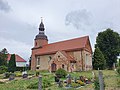
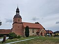
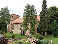
English: Pictures of the church in Laubst, Drebkau municipality, Spree-Neiße district, Brandenburg state, Germany.
Deutsch: Ansichten der Kirche in Laubst, Stadt Drebkau, Landkreis Spree-Neiße, Land Brandenburg, Deutschland.
Français : Photos de l'église à Laubst, ville de Drebkau, arrondissement de Spree-Neiße, état fédéral de Brandebourg, Allemagne
Español: Vistas de la iglesia en Laubst, ciudad de Drebkau, distrito de Spree-Neiße, estado federado de Brandeburgo, Alemania
Address: Laubster Dorfstraße, 03116 Drebkau
Subcategories
This category has the following 2 subcategories, out of 2 total.
C
I
Media in category "Dorfkirche Laubst"
The following 6 files are in this category, out of 6 total.
-
 Dorfkirche Laubst NO 2022.jpg 4,032 × 3,024; 4.36 MB
-
 Dorfkirche Laubst O 2022.jpg 4,032 × 3,024; 5.02 MB
-
 Dorfkirche Laubst SO 2022.jpg 4,032 × 3,024; 4.41 MB
-
 Dorfkirche Laubst SW 2022.jpg 4,032 × 3,024; 2.91 MB
-
 Dorfkirche Laubst Südseite.jpg 4,608 × 3,456; 6.49 MB
-
 Dorfkirche Laubst Vorhalle 2022.jpg 4,032 × 3,024; 4.65 MB


