Category:Dorfkirche Landin (Havelland)
Jump to navigation
Jump to search
| Object location | | View all coordinates using: OpenStreetMap |
|---|
 | |||||
| Upload media | |||||
| Instance of | |||||
|---|---|---|---|---|---|
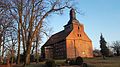
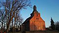
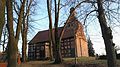
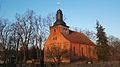
| Location | Landin, Kotzen, Havelland District, Brandenburg, Germany | ||||
| Heritage designation | |||||
 | |||||
This is the category of the Brandenburger Baudenkmal (cultural heritage monument) with the ID 09150145 (Wikidata)
|
Français : Église de Landin, commune de Kotzen, arrondissement Pays de la Havel, état fédéral de Brandebourg, Allemagne
Media in category "Dorfkirche Landin (Havelland)"
The following 7 files are in this category, out of 7 total.
-
 Kirche landin feb2017 - 1.jpg 4,160 × 2,336; 3.13 MB
-
 Kirche landin feb2017 - 2.jpg 4,160 × 2,336; 4.45 MB
-
 Kirche landin feb2017 - 3.jpg 4,160 × 2,336; 3.59 MB
-
 Kirche landin feb2017 - 4.jpg 4,160 × 2,336; 3.33 MB
-
 Kirche landin feb2017 - 5.jpg 4,160 × 2,336; 3.7 MB
-
 Kirche landin feb2017 - 6.jpg 4,160 × 2,336; 2.82 MB
-
 Kirche Landin Kotzen.jpg 3,872 × 2,592; 1.33 MB


