Category:Dorfkirche Kriele
Jump to navigation
Jump to search
| Object location | | View all coordinates using: OpenStreetMap |
|---|
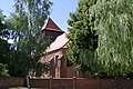
church building in Havelland district, Brandenburg state, Germany  | |||||
| Upload media | |||||
| Instance of | |||||
|---|---|---|---|---|---|
| Location | Kotzen, Havelland District, Brandenburg, Germany | ||||
| Heritage designation | |||||
 | |||||
This is the category of the Brandenburger Baudenkmal (cultural heritage monument) with the ID 09150143 (Wikidata)
|
Français : Église de Kriele, commune de Kotzen, arrondissement Pays de la Havel, état fédéral de Brandebourg, Allemagne
Media in category "Dorfkirche Kriele"
The following 12 files are in this category, out of 12 total.
-
 Dorfkirche Kriele Nordansicht.jpg 4,032 × 3,024; 2.46 MB
-
 Dorfkirche Kriele Nordostansicht.jpg 3,024 × 4,032; 3.93 MB
-
 Dorfkirche Kriele Ostansicht.jpg 3,024 × 4,032; 3.37 MB
-
 Dorfkirche Kriele Schiff Südansicht.jpg 4,032 × 3,024; 4.58 MB
-
 Dorfkirche Kriele Südostansicht.jpg 4,032 × 3,024; 4.12 MB
-
 Dorfkirche Kriele Westturm Nordansicht Glockengeschoss.jpg 3,024 × 4,032; 2.28 MB
-
 Dorfkirche Kriele Westturm Nordansicht.jpg 3,024 × 4,032; 3.01 MB
-
 Dorfkirche Kriele Westturm Südansicht.jpg 3,024 × 4,032; 3.27 MB
-
 Dorfkirche Kriele Westturm und Vorbau Nordansicht.jpg 4,032 × 3,024; 3.34 MB
-
 Dorfkirche Kriele Westturm Westansicht.jpg 3,024 × 4,032; 2.93 MB
-
 Kirche Kriele Kotzen 2.jpg 3,872 × 2,592; 1.45 MB
-
 Kirche Kriele Kotzen.jpg 3,872 × 2,592; 1.86 MB


